Property Record
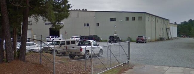
1220 Harold Andrews Rd, Siler City, NC 27344
NEARBY LISTINGS FOR SALE OR LEASE
Property Detail
1220 Harold Andrews Rd
13724
Siler City Outside
Policefirecivildefense
PARCEL E AC 1.478 BK 89 PG 34
X
Chatham
3710876200K
North Carolina
2025
1.48 AC
2025
Chatham County
020402
Raleigh/Durham
40,745 SF
Durham-Chapel Hill, NC
DEMOGRAPHICS near 1220 Harold Andrews Rd
1 Mile
3 Mile
5 Mile
2024 Total Population
586
10,745
14,167
2029 Population
655
12,014
15,880
Pop Growth 2024-2029
+ 11.77%
+ 11.81%
+ 12.09%
Average Age
40
38
40
2024 Total Households
224
3,870
5,247
HH Growth 2024-2029
+ 12.05%
+ 11.96%
+ 12.29%
Median Household Inc
$27,071
$37,050
$39,608
Avg Household Size
2.60
2.70
2.60
2024 Avg HH Vehicles
2.00
2.00
2.00
Median Home Value
$173,683
$140,500
$155,076
Median Year Built
1984
1979
1982
Nearby Places
Map Layers
Map Styles
 Street
 Aerial
- Restaurants
- Banks
- Shops
- Fitness
- Groceries
Nearby Properties
Address
Land Use
TOTAL SIZE
Lot Size
Zoning
Address
Land Use
TOTAL SIZE
Lot Size
Zoning
225,615 SF
11.05 AC
H-I
Address
Land Use
TOTAL SIZE
Lot Size
Zoning
2,145 SF
28.16 AC
O-I
Address
Land Use
TOTAL SIZE
Lot Size
Zoning
364,431 SF
45.55 AC
H-I
Address
Land Use
TOTAL SIZE
Lot Size
Zoning
15.14 AC
O-I
Address
Land Use
TOTAL SIZE
Lot Size
Zoning
152,677 SF
18.78 AC
H-C
Address
Land Use
TOTAL SIZE
Lot Size
Zoning
149,304 SF
18.18 AC
R-10
Address
Land Use
TOTAL SIZE
Lot Size
Zoning
22,416 SF
11.20 AC
R-6
Address
Land Use
TOTAL SIZE
Lot Size
Zoning
136,366 SF
15.85 AC
H-C
Address
Land Use
TOTAL SIZE
Lot Size
Zoning
47,727 SF
10.71 AC
H-C
Address
Land Use
TOTAL SIZE
Lot Size
Zoning
7,280 SF
10.14 AC
R-10
Address
Land Use
TOTAL SIZE
Lot Size
Zoning
1,176 SF
8.01 AC
R-10
Address
Land Use
TOTAL SIZE
Lot Size
Zoning
10,280 SF
24.48 AC
H-I
Address
Land Use
TOTAL SIZE
Lot Size
Zoning
24,034 SF
75.66 AC
A-R
Address
Land Use
TOTAL SIZE
Lot Size
Zoning
24,134 SF
41.42 AC
O-I
Address
Land Use
TOTAL SIZE
Lot Size
Zoning
30,660 SF
18.64 AC
L-I
Address
Land Use
TOTAL SIZE
Lot Size
Zoning
14,704 SF
1.61 AC
H-C
Address
Land Use
TOTAL SIZE
Lot Size
Zoning
65.59 AC
A-R
Address
Land Use
TOTAL SIZE
Lot Size
Zoning
8,923 SF
20.75 AC
SCETJ
Address
Land Use
TOTAL SIZE
Lot Size
Zoning
28,330 SF
9.90 AC
H-I
Address
Land Use
TOTAL SIZE
Lot Size
Zoning
72,499 SF
5.53 AC
L-I
Address
Land Use
TOTAL SIZE
Lot Size
Zoning
43,927 SF
6.64 AC
O-I
Address
Land Use
TOTAL SIZE
Lot Size
Zoning
31,436 SF
5.36 AC
O-I
Address
Land Use
TOTAL SIZE
Lot Size
Zoning
19,384 SF
14.95 AC
R-20
Address
Land Use
TOTAL SIZE
Lot Size
Zoning
11,934 SF
24.12 AC
L-I
Address
Land Use
TOTAL SIZE
Lot Size
Zoning
85,596 SF
35.13 AC
H-I
Address
Land Use
TOTAL SIZE
Lot Size
Zoning
10,125 SF
1.79 AC
H-C
Address
Land Use
TOTAL SIZE
Lot Size
Zoning
119,044 SF
8.31 AC
L-I
Address
Land Use
TOTAL SIZE
Lot Size
Zoning
32,000 SF
4.01 AC
H-C
Address
Land Use
TOTAL SIZE
Lot Size
Zoning
225,524 SF
21.60 AC
H-I
Address
Land Use
TOTAL SIZE
Lot Size
Zoning
70,882 SF
7.81 AC
H-C
The World's #1 Commercial Real Estate Marketplace
Connect with us
© 2026 CoStar Group
The information above has been obtained from sources believed reliable. While we do not doubt its accuracy we have not verified it and make no guarantee, warranty or representation about it. It is your responsibility to independently confirm its accuracy and completeness. Any projections, opinions, assumptions, or estimates used are for example only and do not represent the current or future performance of the property. The value of this transaction to you depends on tax and other factors which should be evaluated by your tax, financial, and legal advisors. You and your advisors should conduct a careful, independent investigation of the property to determine to your satisfaction the suitability of the property for your needs.