Property Record
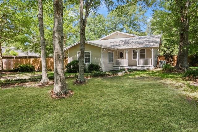
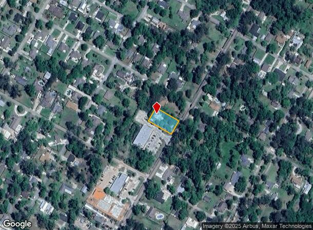
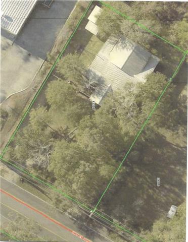
1220 Highway 59, Mandeville, LA 70448
This Property Is For Sale
NEARBY LISTINGS FOR SALE OR LEASE
-
-
View all Mandeville listings for sale on LoopNet.com
Property Detail
1220 Highway 59
Slidell-Mandeville-Covington, LA
Hwy 59 Rural Ward 4
41306
St Tammany
Sfr
Louisiana
ARE
0.41 AC
2202020431D
Mandeville/Covington
2,485 SF
New Orleans/Metairie/Kenner
DEMOGRAPHICS near 1220 Highway 59
1 Mile
3 Mile
5 Mile
2024 Total Population
7,712
36,831
56,361
2029 Population
8,710
41,605
63,705
Pop Growth 2024-2029
+ 12.94%
+ 12.96%
+ 13.03%
Average Age
42
41
41
2024 Total Households
3,040
14,129
21,700
HH Growth 2024-2029
+ 13.09%
+ 13.20%
+ 13.22%
Median Household Inc
$68,833
$82,419
$80,283
Avg Household Size
2.50
2.60
2.50
2024 Avg HH Vehicles
2.00
2.00
2.00
Median Home Value
$279,207
$321,215
$321,137
Median Year Built
1993
1994
1994
Nearby Places
Map Layers
Map Styles
 Street
 Aerial
- Restaurants
- Banks
- Shops
- Fitness
- Groceries
PUBLIC TRANSPORTATION
AIRPORT
Louis Armstrong New Orleans International
DRIVE
WALK
Distance
Louis Armstrong New Orleans International
50 min
36.6 mi
Freight Ports
Port of New Orleans
DRIVE
WALK
Distance
Port of New Orleans
55 min
37.6 mi
Nearby Properties
Address
Land Use
TOTAL SIZE
Lot Size
Zoning
Address
Land Use
TOTAL SIZE
Lot Size
Zoning
266,213 SF
40 AC
Address
Land Use
TOTAL SIZE
Lot Size
Zoning
229,994 SF
30 AC
Address
Land Use
TOTAL SIZE
Lot Size
Zoning
220,860 SF
25.07 AC
Address
Land Use
TOTAL SIZE
Lot Size
Zoning
154,751 SF
14.96 AC
Address
Land Use
TOTAL SIZE
Lot Size
Zoning
199,706 SF
158.50 AC
Address
Land Use
TOTAL SIZE
Lot Size
Zoning
165,168 SF
18.16 AC
Address
Land Use
TOTAL SIZE
Lot Size
Zoning
156,183 SF
20 AC
Address
Land Use
TOTAL SIZE
Lot Size
Zoning
147,457 SF
8.90 AC
Address
Land Use
TOTAL SIZE
Lot Size
Zoning
113,686 SF
10.34 AC
Address
Land Use
TOTAL SIZE
Lot Size
Zoning
128,819 SF
34.92 AC
Address
Land Use
TOTAL SIZE
Lot Size
Zoning
54,226 SF
5.10 AC
Address
Land Use
TOTAL SIZE
Lot Size
Zoning
93,800 SF
10.35 AC
Address
Land Use
TOTAL SIZE
Lot Size
Zoning
206,403 SF
9.06 AC
Address
Land Use
TOTAL SIZE
Lot Size
Zoning
50,560 SF
6.32 AC
Address
Land Use
TOTAL SIZE
Lot Size
Zoning
56,162 SF
5.30 AC
Address
Land Use
TOTAL SIZE
Lot Size
Zoning
100,734 SF
23.66 AC
Address
Land Use
TOTAL SIZE
Lot Size
Zoning
40,064 SF
3.66 AC
Address
Land Use
TOTAL SIZE
Lot Size
Zoning
90,603 SF
6.50 AC
Address
Land Use
TOTAL SIZE
Lot Size
Zoning
43,301 SF
3.26 AC
Address
Land Use
TOTAL SIZE
Lot Size
Zoning
88,002 SF
10 AC
Address
Land Use
TOTAL SIZE
Lot Size
Zoning
86,799 SF
28.55 AC
Address
Land Use
TOTAL SIZE
Lot Size
Zoning
82,479 SF
5.95 AC
Address
Land Use
TOTAL SIZE
Lot Size
Zoning
59,702 SF
5.97 AC
Address
Land Use
TOTAL SIZE
Lot Size
Zoning
48,307 SF
4.79 AC
Address
Land Use
TOTAL SIZE
Lot Size
Zoning
50,608 SF
2.82 AC
Address
Land Use
TOTAL SIZE
Lot Size
Zoning
67,550 SF
3.66 AC
Address
Land Use
TOTAL SIZE
Lot Size
Zoning
60,971 SF
4.80 AC
Address
Land Use
TOTAL SIZE
Lot Size
Zoning
96,475 SF
6.10 AC
Address
Land Use
TOTAL SIZE
Lot Size
Zoning
49,690 SF
4.02 AC
Address
Land Use
TOTAL SIZE
Lot Size
Zoning
36,030 SF
30 AC
The World's #1 Commercial Real Estate Marketplace
Connect with us
© 2026 CoStar Group
The information above has been obtained from sources believed reliable. While we do not doubt its accuracy we have not verified it and make no guarantee, warranty or representation about it. It is your responsibility to independently confirm its accuracy and completeness. Any projections, opinions, assumptions, or estimates used are for example only and do not represent the current or future performance of the property. The value of this transaction to you depends on tax and other factors which should be evaluated by your tax, financial, and legal advisors. You and your advisors should conduct a careful, independent investigation of the property to determine to your satisfaction the suitability of the property for your needs.