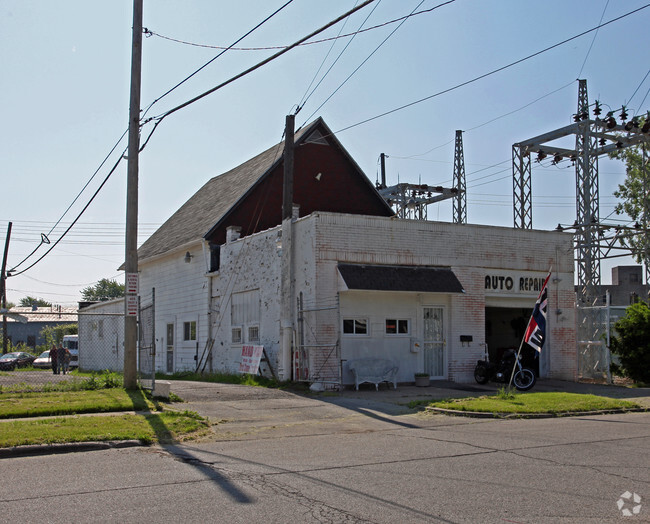
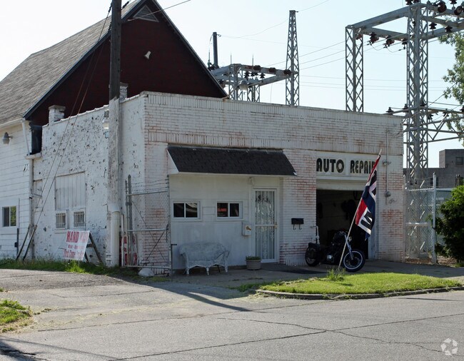
Property Record
1220 Manila St, Toledo, OH 43607

Property Detail
1220 Manila St
04-11747
DORR ST STATION ADDN LOT 49
Parkingstructure
Lucas
10-CR
Ohio
B and X Area of moderate flood hazard, usually the area between the limits of the 100-year and 500-year floods.
49
2025
0.07 AC
2025
West/Sylvania
003100
Toledo
2,964 SF
Toledo, OH
NEARBY LISTINGS FOR SALE OR LEASE
DEMOGRAPHICS near 1220 Manila St
1 mile
3 mile
5 mile
2025 Total Population
12,106
108,281
244,304
2030 Population
12,445
109,059
244,266
Pop Growth 2025-2030
+ 2.80%
+ 0.72%
(0.02%)
Average Age
39
37
39
2025 Total Households
5,260
46,087
104,610
HH Growth 2025-2030
+ 2.70%
+ 0.78%
(0.07%)
Median Household Inc
$42,397
$44,210
$48,280
Avg Household Size
2.20
2.20
2.20
2025 Avg HH Vehicles
1.00
1.00
2.00
Median Home Value
$64,547
$85,494
$110,945
Median Year Built
1948
1949
1953
Nearby Places
Map Layers
Map Styles
 Street
 Aerial
Transit
 Traffic
 Biking
Places
Listings with unknown addresses are not visible on the map
- Restaurants
- Banks
- Shops
- Fitness
- Groceries
PUBLIC TRANSPORTATION
COMMUTER RAIL
Drive
Walk
Distance
7 min
3.2 mi
AIRPORT
Eugene F Kranz Toledo Express
Drive
Walk
Distance
Eugene F Kranz Toledo Express
34 min
18.5 mi
Nearby Properties
Address
Land Use
TOTAL SIZE
Lot Size
Zoning
Address
Land Use
TOTAL SIZE
Lot Size
Zoning
3,101,694 SF
35.64 AC
10-IC
Address
Land Use
TOTAL SIZE
Lot Size
Zoning
3,076,310 SF
127.88 AC
10-MX
Address
Land Use
TOTAL SIZE
Lot Size
Zoning
1,237,446 SF
193.94 AC
10-RS12
Address
Land Use
TOTAL SIZE
Lot Size
Zoning
1,046,727 SF
0.41 AC
10-IC
Address
Land Use
TOTAL SIZE
Lot Size
Zoning
513,157 SF
39.38 AC
10-MX
Address
Land Use
TOTAL SIZE
Lot Size
Zoning
277,862 SF
3 AC
10-CD
Address
Land Use
TOTAL SIZE
Lot Size
Zoning
304,593 SF
24.13 AC
10-IC
Address
Land Use
TOTAL SIZE
Lot Size
Zoning
323,421 SF
134.98 AC
10-IC
Address
Land Use
TOTAL SIZE
Lot Size
Zoning
625,485 SF
2 AC
10-MX
Address
Land Use
TOTAL SIZE
Lot Size
Zoning
111,471 SF
6.17 AC
10-CD
Address
Land Use
TOTAL SIZE
Lot Size
Zoning
171,946 SF
0.17 AC
10-IC
Address
Land Use
TOTAL SIZE
Lot Size
Zoning
328,568 SF
16.37 AC
10-CO
Address
Land Use
TOTAL SIZE
Lot Size
Zoning
202,563 SF
6.19 AC
10-IG
Address
Land Use
TOTAL SIZE
Lot Size
Zoning
245,237 SF
31.72 AC
10-MX
Address
Land Use
TOTAL SIZE
Lot Size
Zoning
243,165 SF
3.63 AC
10-CD
Address
Land Use
TOTAL SIZE
Lot Size
Zoning
1.74 AC
10-CD
Address
Land Use
TOTAL SIZE
Lot Size
Zoning
436,094 SF
30.06 AC
10-RS6
Address
Land Use
TOTAL SIZE
Lot Size
Zoning
296,348 SF
1 AC
10-CO
Address
Land Use
TOTAL SIZE
Lot Size
Zoning
11.16 AC
10-RM24
Address
Land Use
TOTAL SIZE
Lot Size
Zoning
393,343 SF
62.48 AC
10-IC
Address
Land Use
TOTAL SIZE
Lot Size
Zoning
375,323 SF
10-IC
Address
Land Use
TOTAL SIZE
Lot Size
Zoning
72,306 SF
0.09 AC
10-IC
Address
Land Use
TOTAL SIZE
Lot Size
Zoning
148,842 SF
9.84 AC
10-IL
Address
Land Use
TOTAL SIZE
Lot Size
Zoning
246,438 SF
8.22 AC
10-RM36
Address
Land Use
TOTAL SIZE
Lot Size
Zoning
182,983 SF
2 AC
10-CD
Address
Land Use
TOTAL SIZE
Lot Size
Zoning
123,064 SF
10 AC
10-RS6
Address
Land Use
TOTAL SIZE
Lot Size
Zoning
317,139 SF
25.80 AC
10-IC
Address
Land Use
TOTAL SIZE
Lot Size
Zoning
68,517 SF
1.56 AC
10-RM36
Address
Land Use
TOTAL SIZE
Lot Size
Zoning
170,960 SF
4 AC
10-RS6
Address
Land Use
TOTAL SIZE
Lot Size
Zoning
390,272 SF
5 AC
10-CD
The World's #1 Commercial Real Estate Marketplace
Connect with us
© 2026 CoStar Group
The information above has been obtained from sources believed reliable. While we do not doubt its accuracy we have not verified it and make no guarantee, warranty or representation about it. It is your responsibility to independently confirm its accuracy and completeness. Any projections, opinions, assumptions, or estimates used are for example only and do not represent the current or future performance of the property. The value of this transaction to you depends on tax and other factors which should be evaluated by your tax, financial, and legal advisors. You and your advisors should conduct a careful, independent investigation of the property to determine to your satisfaction the suitability of the property for your needs.