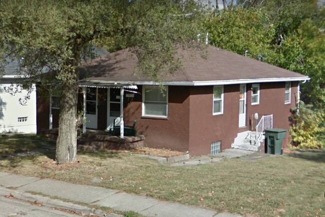
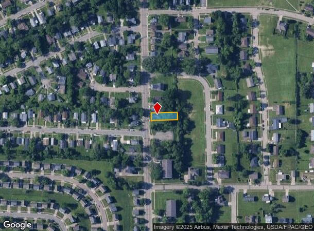
Property Record
1220 Mcarthur Ave, Dayton, OH 45417
NEARBY LISTINGS FOR SALE OR LEASE
Property Detail
1220 Mcarthur Ave
Dayton, OH
City/Dayton Rev
R72-13310-0057
Montgomery
Duplex
Ohio
X
0.16 AC
39113C0251E
Highview Hills
1,170 SF
Cincinnati/Dayton
DEMOGRAPHICS near 1220 Mcarthur Ave
1 Mile
3 Mile
5 Mile
2024 Total Population
7,397
55,328
181,952
2029 Population
7,630
56,960
184,558
Pop Growth 2024-2029
+ 3.15%
+ 2.95%
+ 1.43%
Average Age
36
39
39
2024 Total Households
3,121
23,560
76,601
HH Growth 2024-2029
+ 3.14%
+ 3.02%
+ 1.44%
Median Household Inc
$31,122
$34,740
$42,489
Avg Household Size
2.20
2.20
2.20
2024 Avg HH Vehicles
1.00
1.00
1.00
Median Home Value
$76,933
$78,750
$104,573
Median Year Built
1961
1956
1953
Nearby Places
Map Layers
Map Styles
 Street
 Aerial
- Restaurants
- Banks
- Shops
- Fitness
- Groceries
PUBLIC TRANSPORTATION
AIRPORT
James M Cox Dayton International
DRIVE
WALK
Distance
James M Cox Dayton International
25 min
15.8 mi
Freight Ports
Port of Toledo
DRIVE
WALK
Distance
Port of Toledo
182 min
156.0 mi
SALE & LEASE HISTORY
LISTING DATE
SALE/LEASE

Nov 03, 2022
For Sale
Nearby Properties
Address
Land Use
TOTAL SIZE
Lot Size
Zoning
Address
Land Use
TOTAL SIZE
Lot Size
Zoning
1,570,433 SF
13.34 AC
Address
Land Use
TOTAL SIZE
Lot Size
Zoning
134,515 SF
370.05 AC
Address
Land Use
TOTAL SIZE
Lot Size
Zoning
11.64 AC
Address
Land Use
TOTAL SIZE
Lot Size
Zoning
29,760 SF
5.13 AC
Address
Land Use
TOTAL SIZE
Lot Size
Zoning
125,433 SF
92.08 AC
Address
Land Use
TOTAL SIZE
Lot Size
Zoning
17,478 SF
417.01 AC
Address
Land Use
TOTAL SIZE
Lot Size
Zoning
188,584 SF
2.83 AC
Address
Land Use
TOTAL SIZE
Lot Size
Zoning
1.95 AC
Address
Land Use
TOTAL SIZE
Lot Size
Zoning
424,080 SF
63.14 AC
Address
Land Use
TOTAL SIZE
Lot Size
Zoning
5.41 AC
Address
Land Use
TOTAL SIZE
Lot Size
Zoning
761,679 SF
5.09 AC
Address
Land Use
TOTAL SIZE
Lot Size
Zoning
11.83 AC
Address
Land Use
TOTAL SIZE
Lot Size
Zoning
3.76 AC
Address
Land Use
TOTAL SIZE
Lot Size
Zoning
45,583 SF
4.91 AC
Address
Land Use
TOTAL SIZE
Lot Size
Zoning
128,859 SF
5.31 AC
Address
Land Use
TOTAL SIZE
Lot Size
Zoning
158,144 SF
4.16 AC
Address
Land Use
TOTAL SIZE
Lot Size
Zoning
0.74 AC
Address
Land Use
TOTAL SIZE
Lot Size
Zoning
2.67 AC
Address
Land Use
TOTAL SIZE
Lot Size
Zoning
254,552 SF
9.83 AC
Address
Land Use
TOTAL SIZE
Lot Size
Zoning
317,279 SF
0.84 AC
Address
Land Use
TOTAL SIZE
Lot Size
Zoning
1.61 AC
Address
Land Use
TOTAL SIZE
Lot Size
Zoning
128,246 SF
3.82 AC
Address
Land Use
TOTAL SIZE
Lot Size
Zoning
54.85 AC
Address
Land Use
TOTAL SIZE
Lot Size
Zoning
414,124 SF
14.98 AC
Address
Land Use
TOTAL SIZE
Lot Size
Zoning
94,027 SF
7.99 AC
Address
Land Use
TOTAL SIZE
Lot Size
Zoning
330,404 SF
68.13 AC
Address
Land Use
TOTAL SIZE
Lot Size
Zoning
118,234 SF
25.72 AC
Address
Land Use
TOTAL SIZE
Lot Size
Zoning
327,799 SF
6.50 AC
Address
Land Use
TOTAL SIZE
Lot Size
Zoning
79,822 SF
4.43 AC
Address
Land Use
TOTAL SIZE
Lot Size
Zoning
31.16 AC
The World's #1 Commercial Real Estate Marketplace
Connect with us
© 2025 CoStar Group
The information above has been obtained from sources believed reliable. While we do not doubt its accuracy we have not verified it and make no guarantee, warranty or representation about it. It is your responsibility to independently confirm its accuracy and completeness. Any projections, opinions, assumptions, or estimates used are for example only and do not represent the current or future performance of the property. The value of this transaction to you depends on tax and other factors which should be evaluated by your tax, financial, and legal advisors. You and your advisors should conduct a careful, independent investigation of the property to determine to your satisfaction the suitability of the property for your needs.