Property Record
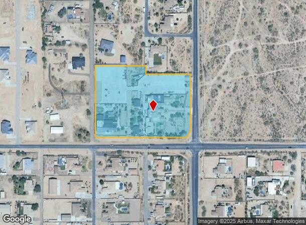
1220 N Signal Butte Rd, Mesa, AZ 85207
NEARBY LISTINGS FOR SALE OR LEASE
Property Detail
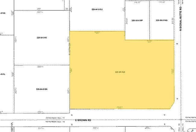
1220 N Signal Butte Rd
220-04-024
PT OF SE4 SEC 11 DAF COM SE COR OF SD SEC 11 TH W 415.70F TH N 40F POB TH W 245.57F TH N 493.36F TH E 330.65F TH S 55F TH E 290.48F TH S 373.33F TH S 31D 52M W 47.24F TH W 350.75F TH S 25F POB P/F 2018-0918061 & AFF OF CORRECTION P/F 2019-0066412 EX
Nightclub
Maricopa
X
Arizona
04013C2305M
6.30 AC
2025
Mesa East
2025
Phoenix
420110
Phoenix-Mesa-Scottsdale, AZ
33,565 SF
DEMOGRAPHICS near 1220 N Signal Butte Rd
1 Mile
3 Mile
5 Mile
2024 Total Population
3,900
67,260
155,087
2029 Population
4,211
76,051
175,599
Pop Growth 2024-2029
+ 7.97%
+ 13.07%
+ 13.23%
Average Age
41
43
45
2024 Total Households
1,297
26,712
63,456
HH Growth 2024-2029
+ 7.94%
+ 13.53%
+ 13.69%
Median Household Inc
$105,180
$61,083
$64,267
Avg Household Size
2.90
2.40
2.40
2024 Avg HH Vehicles
3.00
2.00
2.00
Median Home Value
$531,250
$269,811
$296,387
Median Year Built
1999
1993
1994
Nearby Places
Map Layers
Map Styles
 Street
 Aerial
- Restaurants
- Banks
- Shops
- Fitness
- Groceries
PUBLIC TRANSPORTATION
AIRPORT
Phoenix-Mesa Gateway
DRIVE
WALK
Distance
Phoenix-Mesa Gateway
23 min
14.5 mi
Phoenix Sky Harbor International
DRIVE
WALK
Distance
Phoenix Sky Harbor International
36 min
26.7 mi
Freight Ports
Port of San Diego
DRIVE
WALK
Distance
Port of San Diego
427 min
387.0 mi
Nearby Properties
Address
Land Use
TOTAL SIZE
Lot Size
Zoning
Address
Land Use
TOTAL SIZE
Lot Size
Zoning
209,737 SF
21.98 AC
UNDESIGNAT
Address
Land Use
TOTAL SIZE
Lot Size
Zoning
330,352 SF
28.30 AC
PF
Address
Land Use
TOTAL SIZE
Lot Size
Zoning
173,840 SF
6 AC
UNDESIGNAT
Address
Land Use
TOTAL SIZE
Lot Size
Zoning
6,335 SF
8.30 AC
Address
Land Use
TOTAL SIZE
Lot Size
Zoning
11,686 SF
40 AC
Address
Land Use
TOTAL SIZE
Lot Size
Zoning
23,180 SF
3.90 AC
UNDESIGNAT
Address
Land Use
TOTAL SIZE
Lot Size
Zoning
162,184 SF
4.60 AC
UNDESIGNAT
Address
Land Use
TOTAL SIZE
Lot Size
Zoning
43,958 SF
4.54 AC
UNDESIGNAT
Address
Land Use
TOTAL SIZE
Lot Size
Zoning
24,158 SF
5.19 AC
Address
Land Use
TOTAL SIZE
Lot Size
Zoning
57,258 SF
5.18 AC
UNDESIGNAT
Address
Land Use
TOTAL SIZE
Lot Size
Zoning
244,351 SF
18.46 AC
RS43
Address
Land Use
TOTAL SIZE
Lot Size
Zoning
30,477 SF
3.91 AC
UNDESIGNAT
Address
Land Use
TOTAL SIZE
Lot Size
Zoning
8,710 SF
14.93 AC
Address
Land Use
TOTAL SIZE
Lot Size
Zoning
172,756 SF
8.52 AC
LC
Address
Land Use
TOTAL SIZE
Lot Size
Zoning
Address
Land Use
TOTAL SIZE
Lot Size
Zoning
54,784 SF
5.36 AC
Address
Land Use
TOTAL SIZE
Lot Size
Zoning
80,180 SF
6.44 AC
R-43
Address
Land Use
TOTAL SIZE
Lot Size
Zoning
23,349 SF
2.26 AC
Address
Land Use
TOTAL SIZE
Lot Size
Zoning
35,335 SF
13.79 AC
UNDESIGNAT
Address
Land Use
TOTAL SIZE
Lot Size
Zoning
124,850 SF
12.09 AC
RM4
Address
Land Use
TOTAL SIZE
Lot Size
Zoning
24,600 SF
1.53 AC
UNDESIGNAT
Address
Land Use
TOTAL SIZE
Lot Size
Zoning
87,423 SF
9.43 AC
C-G
Address
Land Use
TOTAL SIZE
Lot Size
Zoning
52,500 SF
16.04 AC
PF
Address
Land Use
TOTAL SIZE
Lot Size
Zoning
23,281 SF
2.34 AC
UNDESIGNAT
Address
Land Use
TOTAL SIZE
Lot Size
Zoning
25,000 SF
1.50 AC
UNDESIGNAT
Address
Land Use
TOTAL SIZE
Lot Size
Zoning
8.05 AC
UNDESIGNAT
Address
Land Use
TOTAL SIZE
Lot Size
Zoning
651 SF
2.83 AC
UNDESIGNAT
Address
Land Use
TOTAL SIZE
Lot Size
Zoning
8,260 SF
0.26 AC
Address
Land Use
TOTAL SIZE
Lot Size
Zoning
105,417 SF
12.18 AC
C-G
Address
Land Use
TOTAL SIZE
Lot Size
Zoning
18,332 SF
1.72 AC
UNDESIGNAT
The World's #1 Commercial Real Estate Marketplace
Connect with us
© 2025 CoStar Group
The information above has been obtained from sources believed reliable. While we do not doubt its accuracy we have not verified it and make no guarantee, warranty or representation about it. It is your responsibility to independently confirm its accuracy and completeness. Any projections, opinions, assumptions, or estimates used are for example only and do not represent the current or future performance of the property. The value of this transaction to you depends on tax and other factors which should be evaluated by your tax, financial, and legal advisors. You and your advisors should conduct a careful, independent investigation of the property to determine to your satisfaction the suitability of the property for your needs.