Property Record
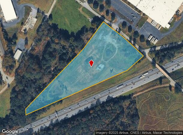
1220 S Batesville Rd, Greer, SC 29650
NEARBY LISTINGS FOR SALE OR LEASE
Property Detail
1220 S Batesville Rd
Greenville-Anderson-Mauldin, SC
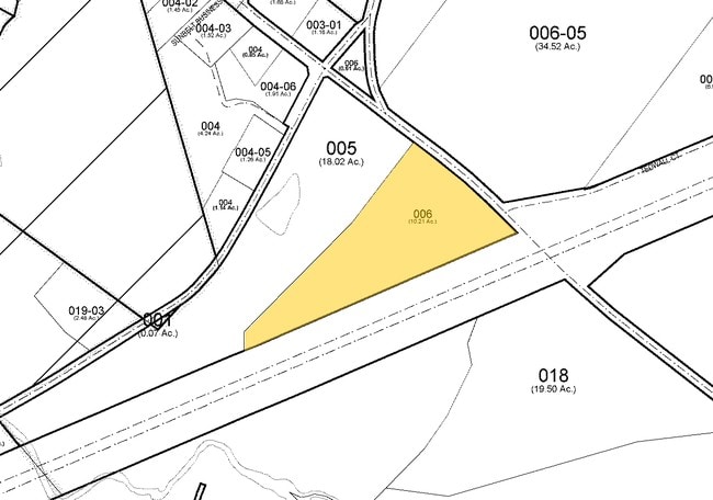
Closing Survey For Billy J Hindman
0530.05-01-006.00
MAP 0530.05
Residentialacreage
Greenville
X
South Carolina
45045C0426E
006.00
2024
9.60 AC
2024
Pelham/I-85
002609
Greenville/Spartanburg
2,452 SF
DEMOGRAPHICS near 1220 S Batesville Rd
1 Mile
3 Mile
5 Mile
2024 Total Population
3,230
43,365
122,045
2029 Population
3,537
47,857
134,561
Pop Growth 2024-2029
+ 9.50%
+ 10.36%
+ 10.26%
Average Age
40
41
40
2024 Total Households
1,385
16,743
48,229
HH Growth 2024-2029
+ 9.68%
+ 10.41%
+ 10.33%
Median Household Inc
$103,818
$101,114
$85,135
Avg Household Size
2.30
2.50
2.50
2024 Avg HH Vehicles
2.00
2.00
2.00
Median Home Value
$530,159
$339,683
$284,901
Median Year Built
1997
1996
1994
Nearby Places
Map Layers
Map Styles
 Street
 Aerial
- Restaurants
- Banks
- Shops
- Fitness
- Groceries
PUBLIC TRANSPORTATION
AIRPORT
Greenville Spartanburg International
DRIVE
WALK
Distance
Greenville Spartanburg International
10 min
5.6 mi
Freight Ports
North Charleston Terminal
DRIVE
WALK
Distance
North Charleston Terminal
227 min
201.8 mi
Nearby Properties
Address
Land Use
TOTAL SIZE
Lot Size
Zoning
Address
Land Use
TOTAL SIZE
Lot Size
Zoning
18.50 AC
RS
Address
Land Use
TOTAL SIZE
Lot Size
Zoning
20.40 AC
RS
Address
Land Use
TOTAL SIZE
Lot Size
Zoning
17.53 AC
I1
Address
Land Use
TOTAL SIZE
Lot Size
Zoning
1,202 SF
14.38 AC
RS
Address
Land Use
TOTAL SIZE
Lot Size
Zoning
86,884 SF
5.31 AC
Address
Land Use
TOTAL SIZE
Lot Size
Zoning
91.80 AC
PD
Address
Land Use
TOTAL SIZE
Lot Size
Zoning
5.20 AC
TI1
Address
Land Use
TOTAL SIZE
Lot Size
Zoning
4.80 AC
I1
Address
Land Use
TOTAL SIZE
Lot Size
Zoning
136.04 AC
I1
Address
Land Use
TOTAL SIZE
Lot Size
Zoning
143.57 AC
I1
Address
Land Use
TOTAL SIZE
Lot Size
Zoning
5.80 AC
RS
Address
Land Use
TOTAL SIZE
Lot Size
Zoning
23.20 AC
PD
Address
Land Use
TOTAL SIZE
Lot Size
Zoning
92.74 AC
R15
Address
Land Use
TOTAL SIZE
Lot Size
Zoning
43.58 AC
RS
Address
Land Use
TOTAL SIZE
Lot Size
Zoning
9.90 AC
I1
Address
Land Use
TOTAL SIZE
Lot Size
Zoning
15.26 AC
Address
Land Use
TOTAL SIZE
Lot Size
Zoning
22.48 AC
I1
Address
Land Use
TOTAL SIZE
Lot Size
Zoning
9.27 AC
I1
Address
Land Use
TOTAL SIZE
Lot Size
Zoning
88.98 AC
RS
Address
Land Use
TOTAL SIZE
Lot Size
Zoning
18.50 AC
PD
Address
Land Use
TOTAL SIZE
Lot Size
Zoning
17.60 AC
PD
Address
Land Use
TOTAL SIZE
Lot Size
Zoning
9.40 AC
RM1
Address
Land Use
TOTAL SIZE
Lot Size
Zoning
3.68 AC
RS
Address
Land Use
TOTAL SIZE
Lot Size
Zoning
2.12 AC
I1
Address
Land Use
TOTAL SIZE
Lot Size
Zoning
26.10 AC
PD
Address
Land Use
TOTAL SIZE
Lot Size
Zoning
29 AC
I1
Address
Land Use
TOTAL SIZE
Lot Size
Zoning
36.18 AC
RS
Address
Land Use
TOTAL SIZE
Lot Size
Zoning
26.29 AC
RS
Address
Land Use
TOTAL SIZE
Lot Size
Zoning
7.20 AC
R20
Address
Land Use
TOTAL SIZE
Lot Size
Zoning
4.80 AC
I1
The World's #1 Commercial Real Estate Marketplace
Connect with us
© 2025 CoStar Group
The information above has been obtained from sources believed reliable. While we do not doubt its accuracy we have not verified it and make no guarantee, warranty or representation about it. It is your responsibility to independently confirm its accuracy and completeness. Any projections, opinions, assumptions, or estimates used are for example only and do not represent the current or future performance of the property. The value of this transaction to you depends on tax and other factors which should be evaluated by your tax, financial, and legal advisors. You and your advisors should conduct a careful, independent investigation of the property to determine to your satisfaction the suitability of the property for your needs.