Property Record
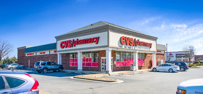
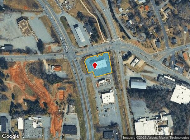
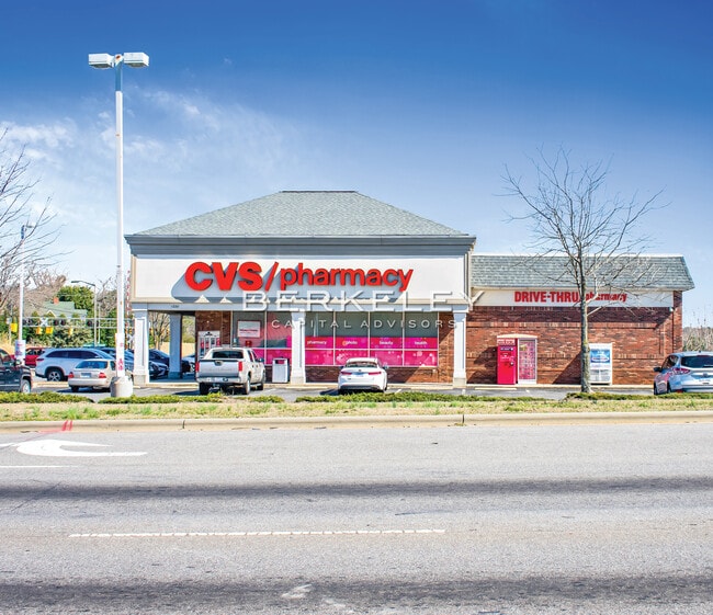
1220 Us Highway 321 Nw, Hickory, NC 28601
NEARBY LISTINGS FOR SALE OR LEASE
Property Detail
1220 Us Highway 321 Nw
Hickory-Lenoir-Morganton, NC
Comprising 1
2793128502900000
LOT 1 PLAT 50-4
Drugstorepharmacycvswalgreens
Catawba
X
North Carolina
3710279300K
1
2024
1.13 AC
2025
Catawba County
010600
Charlotte
10,705 SF
DEMOGRAPHICS near 1220 Us Highway 321 Nw
1 Mile
3 Mile
5 Mile
2024 Total Population
4,611
33,611
69,035
2029 Population
4,784
34,961
71,464
Pop Growth 2024-2029
+ 3.75%
+ 4.02%
+ 3.52%
Average Age
42
41
41
2024 Total Households
1,960
14,094
28,566
HH Growth 2024-2029
+ 3.67%
+ 4.07%
+ 3.57%
Median Household Inc
$58,165
$53,639
$56,811
Avg Household Size
2.30
2.20
2.30
2024 Avg HH Vehicles
2.00
2.00
2.00
Median Home Value
$237,084
$188,594
$190,539
Median Year Built
1972
1973
1979
Nearby Places
Map Layers
Map Styles
 Street
 Aerial
- Restaurants
- Banks
- Shops
- Fitness
- Groceries
SALE & LEASE HISTORY
LISTING DATE
SALE/LEASE

May 12, 2022
For Sale
Jun 16, 2017
For Sale
Jul 11, 2022
For Sale
Apr 18, 2022
For Sale
Nearby Properties
Address
Land Use
TOTAL SIZE
Lot Size
Zoning
Address
Land Use
TOTAL SIZE
Lot Size
Zoning
534,243 SF
285.78 AC
Address
Land Use
TOTAL SIZE
Lot Size
Zoning
10,422 SF
4.23 AC
OI
Address
Land Use
TOTAL SIZE
Lot Size
Zoning
16,594 SF
7.22 AC
PD
Address
Land Use
TOTAL SIZE
Lot Size
Zoning
19.87 AC
OI
Address
Land Use
TOTAL SIZE
Lot Size
Zoning
27.56 AC
OI
Address
Land Use
TOTAL SIZE
Lot Size
Zoning
7,722 SF
10.01 AC
R-4
Address
Land Use
TOTAL SIZE
Lot Size
Zoning
8,436 SF
13.28 AC
R-4
Address
Land Use
TOTAL SIZE
Lot Size
Zoning
9,376 SF
0.75 AC
C-1
Address
Land Use
TOTAL SIZE
Lot Size
Zoning
311,263 SF
37.58 AC
IND
Address
Land Use
TOTAL SIZE
Lot Size
Zoning
7,240 SF
INDUSTRIAL
Address
Land Use
TOTAL SIZE
Lot Size
Zoning
30,415 SF
1.59 AC
C-1
Address
Land Use
TOTAL SIZE
Lot Size
Zoning
146,932 SF
27.08 AC
C-3
Address
Land Use
TOTAL SIZE
Lot Size
Zoning
90,440 SF
5.17 AC
OI
Address
Land Use
TOTAL SIZE
Lot Size
Zoning
9,950 SF
9.42 AC
R-3
Address
Land Use
TOTAL SIZE
Lot Size
Zoning
8,960 SF
14.07 AC
R-4
Address
Land Use
TOTAL SIZE
Lot Size
Zoning
8,637 SF
5 AC
CC-1
Address
Land Use
TOTAL SIZE
Lot Size
Zoning
187,241 SF
25.01 AC
Address
Land Use
TOTAL SIZE
Lot Size
Zoning
14.15 AC
OI
Address
Land Use
TOTAL SIZE
Lot Size
Zoning
22,319 SF
15.57 AC
CC-1
Address
Land Use
TOTAL SIZE
Lot Size
Zoning
8.36 AC
OI
Address
Land Use
TOTAL SIZE
Lot Size
Zoning
7,742 SF
10.93 AC
PD
Address
Land Use
TOTAL SIZE
Lot Size
Zoning
137,227 SF
12.03 AC
NC
Address
Land Use
TOTAL SIZE
Lot Size
Zoning
22.99 AC
PD
Address
Land Use
TOTAL SIZE
Lot Size
Zoning
57,198 SF
16.07 AC
Address
Land Use
TOTAL SIZE
Lot Size
Zoning
301,264 SF
19.88 AC
I
Address
Land Use
TOTAL SIZE
Lot Size
Zoning
2.36 AC
C-1
Address
Land Use
TOTAL SIZE
Lot Size
Zoning
73,702 SF
13.37 AC
C-2
Address
Land Use
TOTAL SIZE
Lot Size
Zoning
8,246 SF
37.33 AC
OI
Address
Land Use
TOTAL SIZE
Lot Size
Zoning
51,052 SF
6.80 AC
CC-1
Address
Land Use
TOTAL SIZE
Lot Size
Zoning
9.07 AC
NC
The World's #1 Commercial Real Estate Marketplace
Connect with us
© 2026 CoStar Group
The information above has been obtained from sources believed reliable. While we do not doubt its accuracy we have not verified it and make no guarantee, warranty or representation about it. It is your responsibility to independently confirm its accuracy and completeness. Any projections, opinions, assumptions, or estimates used are for example only and do not represent the current or future performance of the property. The value of this transaction to you depends on tax and other factors which should be evaluated by your tax, financial, and legal advisors. You and your advisors should conduct a careful, independent investigation of the property to determine to your satisfaction the suitability of the property for your needs.