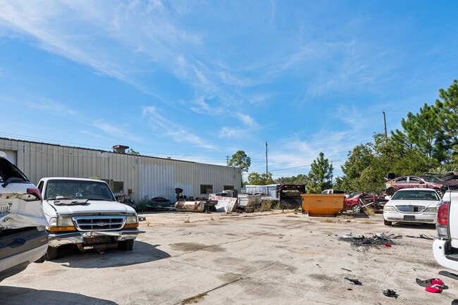
Property Record
1220 W 19Th St, Panama City, FL 32405
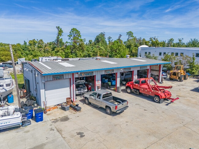

This Property Is For Sale
NEARBY LISTINGS FOR SALE OR LEASE
Property Detail
1220 W 19Th St
13784-022-000
31 3S 14W-1.12- BEG 150 W OF INTER OF E LINE OF SW1/4 OF NE1/4 TH W 150 ALG N R/W OF 19TH ST N 302.90 E 151.47 S 301.45 TO POB. ORB 3020 P 935 *---------MAP 91C1-----------*
Autorepair
Bay
X
Florida
12005C0341J
1.04 AC
2023
Panama City
2024
Other Market Areas
001502
Panama City, FL
2,625 SF
DEMOGRAPHICS near 1220 W 19Th St
1 Mile
3 Mile
5 Mile
2024 Total Population
6,332
31,943
67,493
2029 Population
6,629
33,760
71,260
Pop Growth 2024-2029
+ 4.69%
+ 5.69%
+ 5.58%
Average Age
39
40
40
2024 Total Households
2,543
13,026
26,794
HH Growth 2024-2029
+ 5.15%
+ 6.17%
+ 6.07%
Median Household Inc
$51,957
$54,049
$56,502
Avg Household Size
2.40
2.30
2.40
2024 Avg HH Vehicles
2.00
2.00
2.00
Median Home Value
$166,067
$197,567
$215,044
Median Year Built
1976
1981
1985
Nearby Places
Map Layers
Map Styles
 Street
 Aerial
- Restaurants
- Banks
- Shops
- Fitness
- Groceries
PUBLIC TRANSPORTATION
AIRPORT
Northwest Florida Beaches International
DRIVE
WALK
Distance
Northwest Florida Beaches International
37 min
22.6 mi
Nearby Properties
Address
Land Use
TOTAL SIZE
Lot Size
Zoning
Address
Land Use
TOTAL SIZE
Lot Size
Zoning
764,032 SF
12.80 AC
PC14
Address
Land Use
TOTAL SIZE
Lot Size
Zoning
477,423 SF
21.91 AC
PC09
Address
Land Use
TOTAL SIZE
Lot Size
Zoning
279,378 SF
13.24 AC
PC07
Address
Land Use
TOTAL SIZE
Lot Size
Zoning
648,279 SF
73.10 AC
PC14
Address
Land Use
TOTAL SIZE
Lot Size
Zoning
455,239 SF
11.87 AC
PC11
Address
Land Use
TOTAL SIZE
Lot Size
Zoning
214,953 SF
14.58 AC
PC09
Address
Land Use
TOTAL SIZE
Lot Size
Zoning
354,592 SF
24 AC
UND
Address
Land Use
TOTAL SIZE
Lot Size
Zoning
239,259 SF
15.86 AC
UND
Address
Land Use
TOTAL SIZE
Lot Size
Zoning
252,630 SF
10.70 AC
Address
Land Use
TOTAL SIZE
Lot Size
Zoning
140,899 SF
15.48 AC
PC09
Address
Land Use
TOTAL SIZE
Lot Size
Zoning
86,629 SF
4.70 AC
Address
Land Use
TOTAL SIZE
Lot Size
Zoning
142,051 SF
13.43 AC
PC09
Address
Land Use
TOTAL SIZE
Lot Size
Zoning
208,296 SF
24.72 AC
PC05
Address
Land Use
TOTAL SIZE
Lot Size
Zoning
194,474 SF
16.03 AC
PC09
Address
Land Use
TOTAL SIZE
Lot Size
Zoning
Address
Land Use
TOTAL SIZE
Lot Size
Zoning
68,418 SF
443.51 AC
PC11
Address
Land Use
TOTAL SIZE
Lot Size
Zoning
115,056 SF
21 AC
PC09
Address
Land Use
TOTAL SIZE
Lot Size
Zoning
122,813 SF
9.58 AC
PC09
Address
Land Use
TOTAL SIZE
Lot Size
Zoning
Address
Land Use
TOTAL SIZE
Lot Size
Zoning
238,930 SF
39.18 AC
PSP
Address
Land Use
TOTAL SIZE
Lot Size
Zoning
207,286 SF
3.48 AC
PC10
Address
Land Use
TOTAL SIZE
Lot Size
Zoning
165,098 SF
9.67 AC
PC04
Address
Land Use
TOTAL SIZE
Lot Size
Zoning
81,774 SF
17.46 AC
PC05
Address
Land Use
TOTAL SIZE
Lot Size
Zoning
164,923 SF
23.60 AC
PC09
Address
Land Use
TOTAL SIZE
Lot Size
Zoning
224,823 SF
59.80 AC
PSP
Address
Land Use
TOTAL SIZE
Lot Size
Zoning
118,302 SF
8 AC
PC05
Address
Land Use
TOTAL SIZE
Lot Size
Zoning
41,300 SF
17.87 AC
PC14
Address
Land Use
TOTAL SIZE
Lot Size
Zoning
256,570 SF
7 AC
PC14
Address
Land Use
TOTAL SIZE
Lot Size
Zoning
126,234 SF
20.02 AC
PI
Address
Land Use
TOTAL SIZE
Lot Size
Zoning
62,640 SF
0.48 AC
PC10
The World's #1 Commercial Real Estate Marketplace
Connect with us
© 2026 CoStar Group
The information above has been obtained from sources believed reliable. While we do not doubt its accuracy we have not verified it and make no guarantee, warranty or representation about it. It is your responsibility to independently confirm its accuracy and completeness. Any projections, opinions, assumptions, or estimates used are for example only and do not represent the current or future performance of the property. The value of this transaction to you depends on tax and other factors which should be evaluated by your tax, financial, and legal advisors. You and your advisors should conduct a careful, independent investigation of the property to determine to your satisfaction the suitability of the property for your needs.