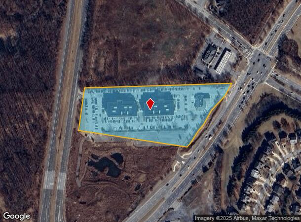
Property Record
12150 Annapolis Rd, Glenn Dale, MD 20769
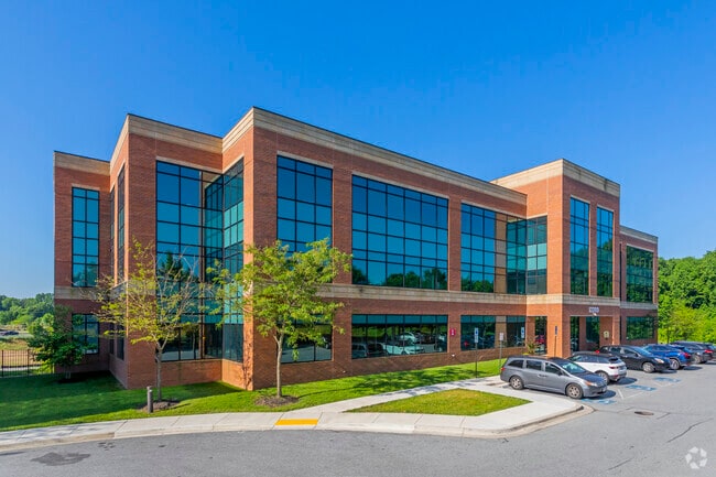


This Property Is For Sale
Current Lease Availabilities
NEARBY LISTINGS FOR SALE OR LEASE
Property Detail
12150 Annapolis Rd
14-3969326
Fairwood Office Park Condo
Officecondo
(OUT OF CYCLE FIN NO CHANGE 7/1/09)
X
Prince George's
24033C0160E
Maryland
2024
0.18 AC
2025
Bowie
800408
Washington, DC
2,652 SF
Washington-Arlington-Alexandria, DC-VA-MD-WV
DEMOGRAPHICS near 12150 Annapolis Rd
1 Mile
3 Mile
5 Mile
2024 Total Population
6,942
64,291
186,052
2029 Population
6,898
62,838
181,362
Pop Growth 2024-2029
(0.63%)
(2.26%)
(2.52%)
Average Age
42
41
41
2024 Total Households
2,176
20,400
62,654
HH Growth 2024-2029
(0.87%)
(2.40%)
(2.65%)
Median Household Inc
$167,583
$132,016
$112,161
Avg Household Size
3.10
3.00
2.90
2024 Avg HH Vehicles
2.00
2.00
2.00
Median Home Value
$576,230
$455,133
$409,553
Median Year Built
2001
1987
1983
Nearby Places
- Restaurants
- Banks
- Shops
- Fitness
- Groceries
PUBLIC TRANSPORTATION
COMMUTER RAIL
Seabrook (PENN - WASHINGTON - Maryland Area Regional Commuter Trains (The MARC), Penn Line - Maryland Area Regional Commuter Trains (The MARC))
DRIVE
WALK
Distance
Seabrook (PENN - WASHINGTON - Maryland Area Regional Commuter Trains (The MARC), Penn Line - Maryland Area Regional Commuter Trains (The MARC))
7 min
4.0 mi
Bowie State Marc Sb (PENN - WASHINGTON - Maryland Transit Administration)
DRIVE
WALK
Distance
Bowie State Marc Sb (PENN - WASHINGTON - Maryland Transit Administration)
12 min
6.2 mi
AIRPORT
Ronald Reagan Washington Ntl
DRIVE
WALK
Distance
Ronald Reagan Washington Ntl
31 min
19.5 mi
Baltimore/Washington International Thurgood Marshall
DRIVE
WALK
Distance
Baltimore/Washington International Thurgood Marshall
38 min
23.6 mi
Freight Ports
Port of Baltimore
DRIVE
WALK
Distance
Port of Baltimore
47 min
30.2 mi
Nearby Properties
Address
Land Use
TOTAL SIZE
Lot Size
Zoning
Address
Land Use
TOTAL SIZE
Lot Size
Zoning
413,915 SF
39.86 AC
IE
Address
Land Use
TOTAL SIZE
Lot Size
Zoning
27.07 AC
RMF20
Address
Land Use
TOTAL SIZE
Lot Size
Zoning
21.35 AC
RMF20
Address
Land Use
TOTAL SIZE
Lot Size
Zoning
20.50 AC
RMF20
Address
Land Use
TOTAL SIZE
Lot Size
Zoning
104,397 SF
27.71 AC
AG
Address
Land Use
TOTAL SIZE
Lot Size
Zoning
187,192 SF
7.15 AC
RE
Address
Land Use
TOTAL SIZE
Lot Size
Zoning
329,080 SF
15.31 AC
IE
Address
Land Use
TOTAL SIZE
Lot Size
Zoning
317 SF
14.09 AC
RMF20
Address
Land Use
TOTAL SIZE
Lot Size
Zoning
1,296 SF
10.78 AC
RMF20
Address
Land Use
TOTAL SIZE
Lot Size
Zoning
192,270 SF
16.35 AC
CGO
Address
Land Use
TOTAL SIZE
Lot Size
Zoning
212,073 SF
32.80 AC
RSF95
Address
Land Use
TOTAL SIZE
Lot Size
Zoning
170,641 SF
4.30 AC
IE
Address
Land Use
TOTAL SIZE
Lot Size
Zoning
73,340 SF
10.72 AC
IE
Address
Land Use
TOTAL SIZE
Lot Size
Zoning
111,684 SF
10.93 AC
CGO
Address
Land Use
TOTAL SIZE
Lot Size
Zoning
88,440 SF
1.54 AC
IE
Address
Land Use
TOTAL SIZE
Lot Size
Zoning
102,545 SF
10.79 AC
CGO
Address
Land Use
TOTAL SIZE
Lot Size
Zoning
129,573 SF
2.49 AC
IE
Address
Land Use
TOTAL SIZE
Lot Size
Zoning
47,132 SF
3.53 AC
LMXC
Address
Land Use
TOTAL SIZE
Lot Size
Zoning
113,902 SF
4.08 AC
IE
Address
Land Use
TOTAL SIZE
Lot Size
Zoning
99,492 SF
9.20 AC
CGO
Address
Land Use
TOTAL SIZE
Lot Size
Zoning
106,334 SF
9.09 AC
IH
Address
Land Use
TOTAL SIZE
Lot Size
Zoning
79,648 SF
2.50 AC
CO
Address
Land Use
TOTAL SIZE
Lot Size
Zoning
115,512 SF
12.82 AC
LMXC
Address
Land Use
TOTAL SIZE
Lot Size
Zoning
122,948 SF
9.77 AC
CGO
Address
Land Use
TOTAL SIZE
Lot Size
Zoning
66,172 SF
2.43 AC
NAC
Address
Land Use
TOTAL SIZE
Lot Size
Zoning
127,400 SF
8.75 AC
IE
Address
Land Use
TOTAL SIZE
Lot Size
Zoning
60,600 SF
6 AC
RR
Address
Land Use
TOTAL SIZE
Lot Size
Zoning
96,160 SF
4.81 AC
IH
Address
Land Use
TOTAL SIZE
Lot Size
Zoning
105,758 SF
11.82 AC
CGO
Address
Land Use
TOTAL SIZE
Lot Size
Zoning
90,382 SF
5.55 AC
IH
The World's #1 Commercial Real Estate Marketplace
Connect with us
© 2025 CoStar Group
The information above has been obtained from sources believed reliable. While we do not doubt its accuracy we have not verified it and make no guarantee, warranty or representation about it. It is your responsibility to independently confirm its accuracy and completeness. Any projections, opinions, assumptions, or estimates used are for example only and do not represent the current or future performance of the property. The value of this transaction to you depends on tax and other factors which should be evaluated by your tax, financial, and legal advisors. You and your advisors should conduct a careful, independent investigation of the property to determine to your satisfaction the suitability of the property for your needs.