Property Record
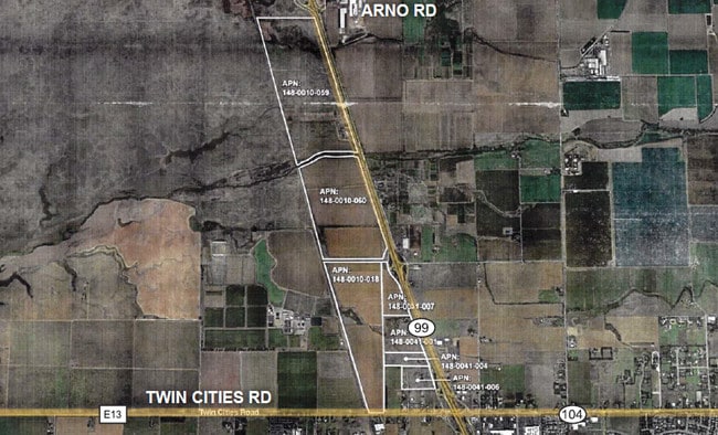
12200 W Stockton Blvd, Galt, CA 95632
This Property Is For Sale
NEARBY LISTINGS FOR SALE OR LEASE
-
-
View all Galt listings for sale on LoopNet.com
Property Detail
12200 W Stockton Blvd
148-0010-059
SUB 62 RANCHO DE SAN JON DE LOS MOQUELUMNES, LOCATED IN SEC 4 TWP 5 N R 6 E M D B & M & CONTG 26 2 ACRES EXC POR DEEDED TO
Pasture
Sacramento
A
California
06077C0050G
158 AC
2024
Outer Sacramento County
2025
Sacramento
009403
Sacramento-Roseville-Folsom, CA
DEMOGRAPHICS near 12200 W Stockton Blvd
1 Mile
3 Mile
5 Mile
2024 Total Population
22
13,352
30,032
2029 Population
21
13,374
30,039
Pop Growth 2024-2029
(4.55%)
+ 0.16%
+ 0.02%
Average Age
43
39
39
2024 Total Households
7
4,321
9,428
HH Growth 2024-2029
0.00%
+ 0.12%
(0.02%)
Median Household Inc
$112,500
$98,283
$85,864
Avg Household Size
2.80
3.10
3.10
2024 Avg HH Vehicles
3.00
2.00
2.00
Median Home Value
$750,000
$460,581
$455,147
Median Year Built
1984
1997
1992
Nearby Places
Map Layers
Map Styles
 Street
 Aerial
- Restaurants
- Banks
- Shops
- Fitness
- Groceries
PUBLIC TRANSPORTATION
AIRPORT
Stockton Metro
DRIVE
WALK
Distance
Stockton Metro
40 min
32.1 mi
Freight Ports
Port of Stockton
DRIVE
WALK
Distance
Port of Stockton
38 min
30.6 mi
Nearby Properties
Address
Land Use
TOTAL SIZE
Lot Size
Zoning
Address
Land Use
TOTAL SIZE
Lot Size
Zoning
284,700 SF
19.12 AC
LM
Address
Land Use
TOTAL SIZE
Lot Size
Zoning
223,974 SF
12.06 AC
LM
Address
Land Use
TOTAL SIZE
Lot Size
Zoning
127,249 SF
11.18 AC
HC
Address
Land Use
TOTAL SIZE
Lot Size
Zoning
65,200 SF
5.04 AC
HC
Address
Land Use
TOTAL SIZE
Lot Size
Zoning
0.99 AC
HC
Address
Land Use
TOTAL SIZE
Lot Size
Zoning
95,616 SF
8.42 AC
R3
Address
Land Use
TOTAL SIZE
Lot Size
Zoning
316.88 AC
AG-80
Address
Land Use
TOTAL SIZE
Lot Size
Zoning
50,732 SF
6.19 AC
R2
Address
Land Use
TOTAL SIZE
Lot Size
Zoning
58 AC
R1C OS
Address
Land Use
TOTAL SIZE
Lot Size
Zoning
21,304 SF
2.91 AC
C
Address
Land Use
TOTAL SIZE
Lot Size
Zoning
17,340 SF
1.80 AC
C
Address
Land Use
TOTAL SIZE
Lot Size
Zoning
324.20 AC
AG-80
Address
Land Use
TOTAL SIZE
Lot Size
Zoning
R1C OS
Address
Land Use
TOTAL SIZE
Lot Size
Zoning
8,844 SF
6.16 AC
OP
Address
Land Use
TOTAL SIZE
Lot Size
Zoning
4.51 AC
LM
Address
Land Use
TOTAL SIZE
Lot Size
Zoning
43,000 SF
1.90 AC
HC
Address
Land Use
TOTAL SIZE
Lot Size
Zoning
2,000 SF
1.04 AC
HC
Address
Land Use
TOTAL SIZE
Lot Size
Zoning
15,900 SF
1.64 AC
HC
Address
Land Use
TOTAL SIZE
Lot Size
Zoning
5,906 SF
17.83 AC
M-2
Address
Land Use
TOTAL SIZE
Lot Size
Zoning
54,000 SF
6.99 AC
LM
Address
Land Use
TOTAL SIZE
Lot Size
Zoning
96.83 AC
AG-80
Address
Land Use
TOTAL SIZE
Lot Size
Zoning
1,986 SF
5 AC
R3
Address
Land Use
TOTAL SIZE
Lot Size
Zoning
10,200 SF
0.99 AC
HC
Address
Land Use
TOTAL SIZE
Lot Size
Zoning
44,304 SF
1.32 AC
HC
Address
Land Use
TOTAL SIZE
Lot Size
Zoning
287.52 AC
AG-80
Address
Land Use
TOTAL SIZE
Lot Size
Zoning
127.70 AC
AG-80
Address
Land Use
TOTAL SIZE
Lot Size
Zoning
1,568 SF
507.50 AC
AG-80 AG-2
Address
Land Use
TOTAL SIZE
Lot Size
Zoning
4,316 SF
1.01 AC
HC
Address
Land Use
TOTAL SIZE
Lot Size
Zoning
3,131 SF
0.72 AC
HC
Address
Land Use
TOTAL SIZE
Lot Size
Zoning
4,907 SF
0.79 AC
C
The World's #1 Commercial Real Estate Marketplace
Connect with us
© 2026 CoStar Group
The information above has been obtained from sources believed reliable. While we do not doubt its accuracy we have not verified it and make no guarantee, warranty or representation about it. It is your responsibility to independently confirm its accuracy and completeness. Any projections, opinions, assumptions, or estimates used are for example only and do not represent the current or future performance of the property. The value of this transaction to you depends on tax and other factors which should be evaluated by your tax, financial, and legal advisors. You and your advisors should conduct a careful, independent investigation of the property to determine to your satisfaction the suitability of the property for your needs.