Property Record
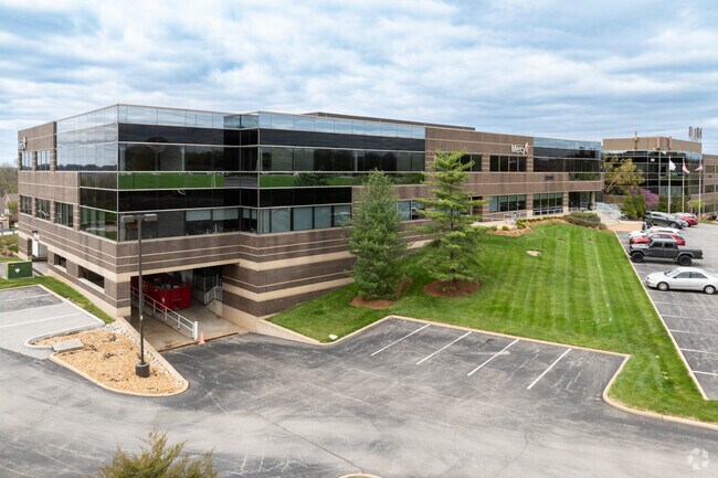
12200 Weber Hill Rd, Saint Louis, MO 63127


Current Lease Availabilities
NEARBY LISTINGS FOR SALE OR LEASE
Property Detail
12200 Weber Hill Rd
St. Louis, MO-IL
Grandview
27M-21-0200
GRANDVIEW OUTLOT PT A
Officebuilding
St. Louis
X
Missouri
29099C0050F
a
2024
6.07 AC
2025
South County
221201
St. Louis
112,128 SF
DEMOGRAPHICS near 12200 Weber Hill Rd
1 Mile
3 Mile
5 Mile
2024 Total Population
4,362
46,844
175,714
2029 Population
4,501
46,152
172,635
Pop Growth 2024-2029
+ 3.19%
(1.48%)
(1.75%)
Average Age
53
44
43
2024 Total Households
1,651
19,231
74,127
HH Growth 2024-2029
+ 4.06%
(1.47%)
(1.81%)
Median Household Inc
$104,243
$89,242
$82,873
Avg Household Size
2.30
2.40
2.30
2024 Avg HH Vehicles
2.00
2.00
2.00
Median Home Value
$607,466
$297,774
$282,820
Median Year Built
1990
1968
1970
Nearby Places
Map Layers
Map Styles
 Street
 Aerial
- Restaurants
- Banks
- Shops
- Fitness
- Groceries
PUBLIC TRANSPORTATION
COMMUTER RAIL
DRIVE
WALK
Distance
11 min
5.5 mi
Shrewsbury-Lansdowne (Shrewsbury-Lansdowne I-44 Emerson Park - St. Louis MetroLink (MetroLink))
DRIVE
WALK
Distance
Shrewsbury-Lansdowne (Shrewsbury-Lansdowne I-44 Emerson Park - St. Louis MetroLink (MetroLink))
15 min
9.6 mi
AIRPORT
St Louis Lambert International
DRIVE
WALK
Distance
St Louis Lambert International
32 min
20.8 mi
Scott AFB/Midamerica St Louis
DRIVE
WALK
Distance
Scott AFB/Midamerica St Louis
58 min
41.6 mi
Nearby Properties
Address
Land Use
TOTAL SIZE
Lot Size
Zoning
Address
Land Use
TOTAL SIZE
Lot Size
Zoning
31.45 AC
Address
Land Use
TOTAL SIZE
Lot Size
Zoning
31.42 AC
R2
Address
Land Use
TOTAL SIZE
Lot Size
Zoning
93,822 SF
33.97 AC
C-8
Address
Land Use
TOTAL SIZE
Lot Size
Zoning
851,923 SF
32.28 AC
101PDMXD
Address
Land Use
TOTAL SIZE
Lot Size
Zoning
289,641 SF
24.38 AC
101PD-BC
Address
Land Use
TOTAL SIZE
Lot Size
Zoning
Address
Land Use
TOTAL SIZE
Lot Size
Zoning
255,646 SF
19.76 AC
32B5
Address
Land Use
TOTAL SIZE
Lot Size
Zoning
460,421 SF
34.91 AC
21BP-2
Address
Land Use
TOTAL SIZE
Lot Size
Zoning
5,040 SF
53.51 AC
101R-1
Address
Land Use
TOTAL SIZE
Lot Size
Zoning
139,212 SF
15.58 AC
21C-1
Address
Land Use
TOTAL SIZE
Lot Size
Zoning
224,872 SF
34.78 AC
21BP-2
Address
Land Use
TOTAL SIZE
Lot Size
Zoning
154,844 SF
13.29 AC
21OT-3
Address
Land Use
TOTAL SIZE
Lot Size
Zoning
26.62 AC
R3
Address
Land Use
TOTAL SIZE
Lot Size
Zoning
129,090 SF
17.78 AC
21C-1
Address
Land Use
TOTAL SIZE
Lot Size
Zoning
114,244 SF
5.74 AC
101PD-BC
Address
Land Use
TOTAL SIZE
Lot Size
Zoning
6.93 AC
101R-2
Address
Land Use
TOTAL SIZE
Lot Size
Zoning
113,971 SF
6.64 AC
C-8
Address
Land Use
TOTAL SIZE
Lot Size
Zoning
103,204 SF
1.47 AC
C-8
Address
Land Use
TOTAL SIZE
Lot Size
Zoning
117,399 SF
0.81 AC
Address
Land Use
TOTAL SIZE
Lot Size
Zoning
90,223 SF
8.51 AC
PD3-C
Address
Land Use
TOTAL SIZE
Lot Size
Zoning
132,860 SF
4.91 AC
32B5
Address
Land Use
TOTAL SIZE
Lot Size
Zoning
65,702 SF
12.33 AC
21HP-1
Address
Land Use
TOTAL SIZE
Lot Size
Zoning
221,724 SF
21.98 AC
21OT-4
Address
Land Use
TOTAL SIZE
Lot Size
Zoning
21.55 AC
C-8
Address
Land Use
TOTAL SIZE
Lot Size
Zoning
22.67 AC
PCD
Address
Land Use
TOTAL SIZE
Lot Size
Zoning
262,264 SF
16.27 AC
R6
Address
Land Use
TOTAL SIZE
Lot Size
Zoning
2,369 SF
10.70 AC
R4
Address
Land Use
TOTAL SIZE
Lot Size
Zoning
91,465 SF
29.86 AC
21CP-1
Address
Land Use
TOTAL SIZE
Lot Size
Zoning
164,166 SF
16.88 AC
21C-1
Address
Land Use
TOTAL SIZE
Lot Size
Zoning
36,112 SF
84.29 AC
AA
The World's #1 Commercial Real Estate Marketplace
Connect with us
© 2025 CoStar Group
The information above has been obtained from sources believed reliable. While we do not doubt its accuracy we have not verified it and make no guarantee, warranty or representation about it. It is your responsibility to independently confirm its accuracy and completeness. Any projections, opinions, assumptions, or estimates used are for example only and do not represent the current or future performance of the property. The value of this transaction to you depends on tax and other factors which should be evaluated by your tax, financial, and legal advisors. You and your advisors should conduct a careful, independent investigation of the property to determine to your satisfaction the suitability of the property for your needs.