Property Record
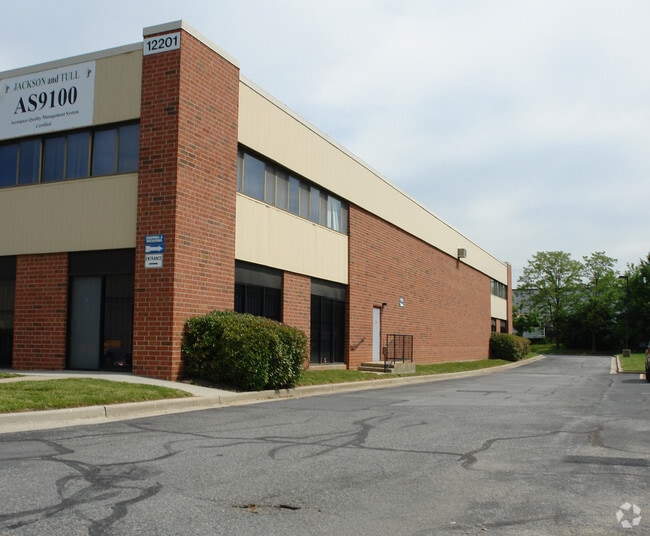
12201 Distribution Way, Beltsville, MD 20705


Current Lease Availabilities
NEARBY LISTINGS FOR SALE OR LEASE
Property Detail
12201 Distribution Way
Washington-Arlington-Alexandria, DC-VA-MD-WV
Muirkirk Indust Center
01-0033464
PARCEL 9B
Warehouse
Prince George's
X
Maryland
24033C0042E
9-b
2023
3.32 AC
2025
Beltsville
807408
Washington, DC
63,796 SF
DEMOGRAPHICS near 12201 Distribution Way
1 Mile
3 Mile
5 Mile
2024 Total Population
4,820
69,500
216,202
2029 Population
4,803
68,004
212,890
Pop Growth 2024-2029
(0.35%)
(2.15%)
(1.53%)
Average Age
39
39
38
2024 Total Households
1,776
25,651
77,970
HH Growth 2024-2029
(0.56%)
(2.26%)
(1.65%)
Median Household Inc
$110,779
$90,688
$88,301
Avg Household Size
2.70
2.60
2.60
2024 Avg HH Vehicles
2.00
2.00
2.00
Median Home Value
$449,369
$408,474
$388,969
Median Year Built
2009
1984
1981
Nearby Places
Map Layers
Map Styles
 Street
 Aerial
- Restaurants
- Banks
- Shops
- Fitness
- Groceries
PUBLIC TRANSPORTATION
COMMUTER RAIL
Muirkirk (CAMDEN - WASHINGTON - Maryland Area Regional Commuter Trains (The MARC), Camden Line - Maryland Area Regional Commuter Trains (The MARC))
DRIVE
WALK
Distance
Muirkirk (CAMDEN - WASHINGTON - Maryland Area Regional Commuter Trains (The MARC), Camden Line - Maryland Area Regional Commuter Trains (The MARC))
3 min
17 min
0.9 mi
Greenbelt (Green Line - Washington Metropolitan Area Transit Authority Metrorail (Metrorail))
DRIVE
WALK
Distance
Greenbelt (Green Line - Washington Metropolitan Area Transit Authority Metrorail (Metrorail))
11 min
5.5 mi
AIRPORT
Baltimore/Washington International Thurgood Marshall
DRIVE
WALK
Distance
Baltimore/Washington International Thurgood Marshall
31 min
19.3 mi
Ronald Reagan Washington Ntl
DRIVE
WALK
Distance
Ronald Reagan Washington Ntl
37 min
21.7 mi
Freight Ports
Port of Baltimore
DRIVE
WALK
Distance
Port of Baltimore
36 min
25.7 mi
Nearby Properties
Address
Land Use
TOTAL SIZE
Lot Size
Zoning
Address
Land Use
TOTAL SIZE
Lot Size
Zoning
393,970 SF
44 AC
RR
Address
Land Use
TOTAL SIZE
Lot Size
Zoning
218,406 SF
26.80 AC
LAUR
Address
Land Use
TOTAL SIZE
Lot Size
Zoning
399,715 SF
23.04 AC
LAUR
Address
Land Use
TOTAL SIZE
Lot Size
Zoning
791,089 SF
10.69 AC
LAUR
Address
Land Use
TOTAL SIZE
Lot Size
Zoning
531,312 SF
25.70 AC
R30
Address
Land Use
TOTAL SIZE
Lot Size
Zoning
657,100 SF
7.39 AC
LAUR
Address
Land Use
TOTAL SIZE
Lot Size
Zoning
514,064 SF
7.37 AC
NAC
Address
Land Use
TOTAL SIZE
Lot Size
Zoning
390,986 SF
16.87 AC
LAUR
Address
Land Use
TOTAL SIZE
Lot Size
Zoning
564,165 SF
35.85 AC
RMF12
Address
Land Use
TOTAL SIZE
Lot Size
Zoning
559,944 SF
11.89 AC
IE
Address
Land Use
TOTAL SIZE
Lot Size
Zoning
104,067 SF
25.29 AC
RMF20
Address
Land Use
TOTAL SIZE
Lot Size
Zoning
2,240.90 AC
ROS
Address
Land Use
TOTAL SIZE
Lot Size
Zoning
165,236 SF
5.24 AC
LAUR
Address
Land Use
TOTAL SIZE
Lot Size
Zoning
769.33 AC
ROS
Address
Land Use
TOTAL SIZE
Lot Size
Zoning
158,316 SF
20.30 AC
LAUR
Address
Land Use
TOTAL SIZE
Lot Size
Zoning
302,887 SF
24.96 AC
LAUR
Address
Land Use
TOTAL SIZE
Lot Size
Zoning
16.36 AC
RMF20
Address
Land Use
TOTAL SIZE
Lot Size
Zoning
16.09 AC
RMF20
Address
Land Use
TOTAL SIZE
Lot Size
Zoning
235,616 SF
12.81 AC
R30
Address
Land Use
TOTAL SIZE
Lot Size
Zoning
15.70 AC
RMF20
Address
Land Use
TOTAL SIZE
Lot Size
Zoning
182,199 SF
43.70 AC
IE
Address
Land Use
TOTAL SIZE
Lot Size
Zoning
547.89 AC
ROS
Address
Land Use
TOTAL SIZE
Lot Size
Zoning
11.20 AC
RMF20
Address
Land Use
TOTAL SIZE
Lot Size
Zoning
11.01 AC
RMF20
Address
Land Use
TOTAL SIZE
Lot Size
Zoning
11.01 AC
RMF20
Address
Land Use
TOTAL SIZE
Lot Size
Zoning
155,461 SF
6.33 AC
CGO
Address
Land Use
TOTAL SIZE
Lot Size
Zoning
73.70 AC
ROS
Address
Land Use
TOTAL SIZE
Lot Size
Zoning
9.14 AC
LAUR
Address
Land Use
TOTAL SIZE
Lot Size
Zoning
37,872 SF
10.29 AC
RMF20
Address
Land Use
TOTAL SIZE
Lot Size
Zoning
253,396 SF
5.96 AC
LAUR
The World's #1 Commercial Real Estate Marketplace
Connect with us
© 2026 CoStar Group
The information above has been obtained from sources believed reliable. While we do not doubt its accuracy we have not verified it and make no guarantee, warranty or representation about it. It is your responsibility to independently confirm its accuracy and completeness. Any projections, opinions, assumptions, or estimates used are for example only and do not represent the current or future performance of the property. The value of this transaction to you depends on tax and other factors which should be evaluated by your tax, financial, and legal advisors. You and your advisors should conduct a careful, independent investigation of the property to determine to your satisfaction the suitability of the property for your needs.