Property Record
12201 Belair Rd, Nottingham, MD 21236
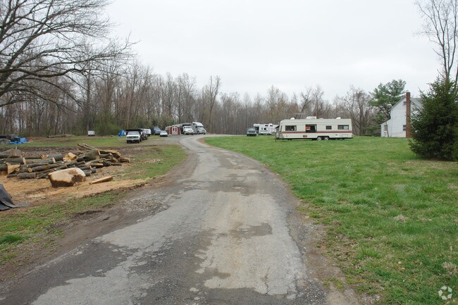

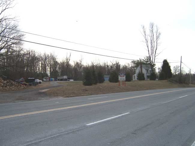
This Property Is For Sale
NEARBY LISTINGS FOR SALE OR LEASE
-
-
View all Nottingham listings for sale on LoopNet.com
Property Detail
12201 Belair Rd
11-1103037950
9.275 AC
Commercialnec
Baltimore
X
Maryland
2400100285G
9.27 AC
2024
Baltimore County East
2025
Baltimore
411306
Baltimore-Columbia-Towson, MD
982 SF
DEMOGRAPHICS near 12201 Belair Rd
1 Mile
3 Mile
5 Mile
2024 Total Population
1,760
11,807
66,029
2029 Population
1,732
11,873
66,520
Pop Growth 2024-2029
(1.59%)
+ 0.56%
+ 0.74%
Average Age
47
46
42
2024 Total Households
661
4,372
24,475
HH Growth 2024-2029
(1.66%)
+ 0.48%
+ 0.74%
Median Household Inc
$116,197
$117,113
$111,475
Avg Household Size
2.60
2.70
2.60
2024 Avg HH Vehicles
2.00
2.00
2.00
Median Home Value
$471,367
$423,485
$364,024
Median Year Built
1967
1971
1985
Nearby Places
Map Layers
Map Styles
 Street
 Aerial
- Restaurants
- Banks
- Shops
- Fitness
- Groceries
PUBLIC TRANSPORTATION
AIRPORT
Baltimore/Washington International Thurgood Marshall
DRIVE
WALK
Distance
Baltimore/Washington International Thurgood Marshall
46 min
29.4 mi
Freight Ports
Port of Baltimore
DRIVE
WALK
Distance
Port of Baltimore
33 min
20.7 mi
Nearby Properties
Address
Land Use
TOTAL SIZE
Lot Size
Zoning
Address
Land Use
TOTAL SIZE
Lot Size
Zoning
2,520 SF
13.77 AC
B3
Address
Land Use
TOTAL SIZE
Lot Size
Zoning
16,129 SF
58.25 AC
AG
Address
Land Use
TOTAL SIZE
Lot Size
Zoning
6,889 SF
7.83 AC
B3
Address
Land Use
TOTAL SIZE
Lot Size
Zoning
53,500 SF
13 AC
RC5
Address
Land Use
TOTAL SIZE
Lot Size
Zoning
40,035 SF
13.54 AC
Address
Land Use
TOTAL SIZE
Lot Size
Zoning
13,206 SF
1.81 AC
B3
Address
Land Use
TOTAL SIZE
Lot Size
Zoning
1,030 SF
5.36 AC
B3
Address
Land Use
TOTAL SIZE
Lot Size
Zoning
40,148 SF
16.38 AC
Address
Land Use
TOTAL SIZE
Lot Size
Zoning
8,274 SF
262.80 AC
AG
Address
Land Use
TOTAL SIZE
Lot Size
Zoning
18,030 SF
3.86 AC
Address
Land Use
TOTAL SIZE
Lot Size
Zoning
33,298 SF
4.75 AC
RC2
Address
Land Use
TOTAL SIZE
Lot Size
Zoning
8,636 SF
1.22 AC
B3
Address
Land Use
TOTAL SIZE
Lot Size
Zoning
38,751 SF
10.51 AC
Address
Land Use
TOTAL SIZE
Lot Size
Zoning
6,400 SF
5.88 AC
CI
Address
Land Use
TOTAL SIZE
Lot Size
Zoning
20,849 SF
7.46 AC
Address
Land Use
TOTAL SIZE
Lot Size
Zoning
19,594 SF
20.71 AC
Address
Land Use
TOTAL SIZE
Lot Size
Zoning
17,422 SF
1.35 AC
B3
Address
Land Use
TOTAL SIZE
Lot Size
Zoning
3,539 SF
0.75 AC
B3
Address
Land Use
TOTAL SIZE
Lot Size
Zoning
4,410 SF
1.03 AC
B3
Address
Land Use
TOTAL SIZE
Lot Size
Zoning
7,500 SF
2.20 AC
B3
Address
Land Use
TOTAL SIZE
Lot Size
Zoning
7,376 SF
2.40 AC
B3
Address
Land Use
TOTAL SIZE
Lot Size
Zoning
1,250 SF
2.27 AC
B3 AG
Address
Land Use
TOTAL SIZE
Lot Size
Zoning
8,400 SF
1.01 AC
B3
Address
Land Use
TOTAL SIZE
Lot Size
Zoning
14,408 SF
7.35 AC
DR1
Address
Land Use
TOTAL SIZE
Lot Size
Zoning
4,000 SF
2.63 AC
B2
Address
Land Use
TOTAL SIZE
Lot Size
Zoning
14,000 SF
0.64 AC
B3
Address
Land Use
TOTAL SIZE
Lot Size
Zoning
15,000 SF
8.97 AC
CI
Address
Land Use
TOTAL SIZE
Lot Size
Zoning
4,690 SF
0.82 AC
B3
Address
Land Use
TOTAL SIZE
Lot Size
Zoning
11,324 SF
7.04 AC
B3/AG
Address
Land Use
TOTAL SIZE
Lot Size
Zoning
2,934 SF
0.99 AC
B2
The World's #1 Commercial Real Estate Marketplace
Connect with us
© 2026 CoStar Group
The information above has been obtained from sources believed reliable. While we do not doubt its accuracy we have not verified it and make no guarantee, warranty or representation about it. It is your responsibility to independently confirm its accuracy and completeness. Any projections, opinions, assumptions, or estimates used are for example only and do not represent the current or future performance of the property. The value of this transaction to you depends on tax and other factors which should be evaluated by your tax, financial, and legal advisors. You and your advisors should conduct a careful, independent investigation of the property to determine to your satisfaction the suitability of the property for your needs.