Property Record
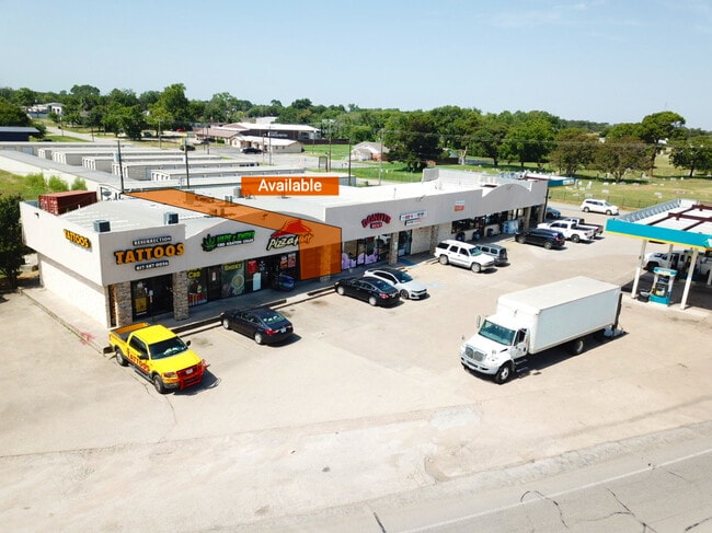
12201 Rendon Rd, Burleson, TX 76028


Property Detail
12201 Rendon Rd
05960215
RENDON, JOAQUIN SURVEY ABSTRACT 1263 TRACT 26F03
Commercialnec
Tarrant
B and X Area of moderate flood hazard, usually the area between the limits of the 100-year and 500-year floods.
Texas
2025
1 AC
2025
SE Outlying Tarrant
111317
Dallas/Ft Worth
10,782 SF
Dallas-Fort Worth-Arlington, TX
NEARBY LISTINGS FOR SALE OR LEASE
DEMOGRAPHICS near 12201 Rendon Rd
1 mile
3 mile
5 mile
2025 Total Population
2,525
16,213
71,862
2030 Population
2,689
17,375
77,285
Pop Growth 2025-2030
+ 6.50%
+ 7.17%
+ 7.55%
Average Age
43
42
38
2025 Total Households
882
5,554
23,859
HH Growth 2025-2030
+ 6.69%
+ 7.24%
+ 7.68%
Median Household Inc
$107,532
$108,699
$95,019
Avg Household Size
2.70
2.80
2.90
2025 Avg HH Vehicles
3.00
2.00
2.00
Median Home Value
$366,354
$400,390
$356,475
Median Year Built
1990
1995
1999
Nearby Places
Map Layers
Map Styles
 Street
 Aerial
Layers
 Traffic
 Biking
Places
Listings with unknown addresses are not visible on the map
- Restaurants
- Banks
- Shops
- Fitness
- Groceries
PUBLIC TRANSPORTATION
AIRPORT
Dallas-Fort Worth International
Drive
Walk
Distance
Dallas-Fort Worth International
49 min
34.7 mi
Dallas Love Field
Drive
Walk
Distance
Dallas Love Field
60 min
44.5 mi
SALE & LEASE HISTORY
LISTING DATE
SALE/LEASE

May 30, 2017
For Lease
Jan 19, 2024
For Lease
Dec 08, 2022
For Lease
Nearby Properties
Address
Land Use
TOTAL SIZE
Lot Size
Zoning
Address
Land Use
TOTAL SIZE
Lot Size
Zoning
199,066 SF
66.49 AC
Address
Land Use
TOTAL SIZE
Lot Size
Zoning
101,412 SF
7.36 AC
Address
Land Use
TOTAL SIZE
Lot Size
Zoning
77,845 SF
13.52 AC
Address
Land Use
TOTAL SIZE
Lot Size
Zoning
3,852 SF
5.75 AC
Address
Land Use
TOTAL SIZE
Lot Size
Zoning
37,500 SF
1 AC
Address
Land Use
TOTAL SIZE
Lot Size
Zoning
45,285 SF
19.97 AC
Address
Land Use
TOTAL SIZE
Lot Size
Zoning
35,440 SF
16 AC
Address
Land Use
TOTAL SIZE
Lot Size
Zoning
41,104 SF
2.87 AC
Address
Land Use
TOTAL SIZE
Lot Size
Zoning
66,000 SF
10.35 AC
Address
Land Use
TOTAL SIZE
Lot Size
Zoning
58,437 SF
17 AC
Address
Land Use
TOTAL SIZE
Lot Size
Zoning
36,348 SF
7.52 AC
Address
Land Use
TOTAL SIZE
Lot Size
Zoning
49,880 SF
13.27 AC
Address
Land Use
TOTAL SIZE
Lot Size
Zoning
35,790 SF
2.30 AC
Address
Land Use
TOTAL SIZE
Lot Size
Zoning
14,424 SF
4.45 AC
Address
Land Use
TOTAL SIZE
Lot Size
Zoning
30,302 SF
2.50 AC
Address
Land Use
TOTAL SIZE
Lot Size
Zoning
31,200 SF
3.59 AC
Address
Land Use
TOTAL SIZE
Lot Size
Zoning
47,334 SF
5 AC
Address
Land Use
TOTAL SIZE
Lot Size
Zoning
35,110 SF
4.58 AC
Address
Land Use
TOTAL SIZE
Lot Size
Zoning
50,000 SF
4.70 AC
Address
Land Use
TOTAL SIZE
Lot Size
Zoning
49,174 SF
3.89 AC
Address
Land Use
TOTAL SIZE
Lot Size
Zoning
41,980 SF
7.56 AC
Address
Land Use
TOTAL SIZE
Lot Size
Zoning
9,944 SF
7.04 AC
Address
Land Use
TOTAL SIZE
Lot Size
Zoning
13,238 SF
4.68 AC
Address
Land Use
TOTAL SIZE
Lot Size
Zoning
48,000 SF
12.16 AC
Address
Land Use
TOTAL SIZE
Lot Size
Zoning
9,100 SF
2 AC
Address
Land Use
TOTAL SIZE
Lot Size
Zoning
1,719 SF
84.72 AC
Address
Land Use
TOTAL SIZE
Lot Size
Zoning
22,750 SF
6.20 AC
Address
Land Use
TOTAL SIZE
Lot Size
Zoning
31,300 SF
2.50 AC
Address
Land Use
TOTAL SIZE
Lot Size
Zoning
13,260 SF
8.70 AC
Address
Land Use
TOTAL SIZE
Lot Size
Zoning
25,000 SF
4.44 AC
The World's #1 Commercial Real Estate Marketplace
Connect with us
© 2026 CoStar Group
The information above has been obtained from sources believed reliable. While we do not doubt its accuracy we have not verified it and make no guarantee, warranty or representation about it. It is your responsibility to independently confirm its accuracy and completeness. Any projections, opinions, assumptions, or estimates used are for example only and do not represent the current or future performance of the property. The value of this transaction to you depends on tax and other factors which should be evaluated by your tax, financial, and legal advisors. You and your advisors should conduct a careful, independent investigation of the property to determine to your satisfaction the suitability of the property for your needs.