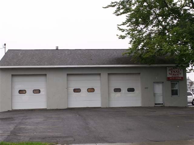
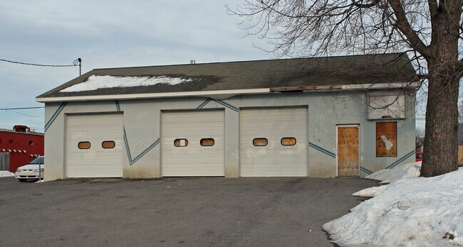
Property Record
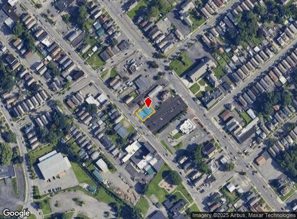
1221 Albany St, Schenectady, NY 12304
NEARBY LISTINGS FOR SALE OR LEASE
Property Detail
1221 Albany St
049-059-0002-039-000-0000
AND HALF OF 36 VACANT LOT
Religious
Schenectady
X
New York
36093C0170D
39.000
2024
0.13 AC
2024
Greater Schenectady
021802
Albany/Schenectady/Troy
1,815 SF
Albany-Schenectady-Troy, NY
DEMOGRAPHICS near 1221 Albany St
1 Mile
3 Mile
5 Mile
2024 Total Population
25,687
108,844
155,577
2029 Population
26,828
114,502
162,808
Pop Growth 2024-2029
+ 4.44%
+ 5.20%
+ 4.65%
Average Age
36
40
41
2024 Total Households
9,825
45,258
64,170
HH Growth 2024-2029
+ 4.76%
+ 5.48%
+ 4.91%
Median Household Inc
$45,940
$65,187
$74,569
Avg Household Size
2.50
2.30
2.30
2024 Avg HH Vehicles
1.00
1.00
2.00
Median Home Value
$118,516
$168,456
$194,174
Median Year Built
1946
1950
1956
Nearby Places
Map Layers
Map Styles
 Street
 Aerial
- Restaurants
- Banks
- Shops
- Fitness
- Groceries
PUBLIC TRANSPORTATION
COMMUTER RAIL
DRIVE
WALK
Distance
5 min
1.6 mi
AIRPORT
Albany International
DRIVE
WALK
Distance
Albany International
18 min
8.8 mi
Freight Ports
Albany, NY Port
DRIVE
WALK
Distance
Albany, NY Port
27 min
18.3 mi
Nearby Properties
Address
Land Use
TOTAL SIZE
Lot Size
Zoning
Address
Land Use
TOTAL SIZE
Lot Size
Zoning
2,068,862 SF
204.52 AC
I-2
Address
Land Use
TOTAL SIZE
Lot Size
Zoning
583,211 SF
9.95 AC
03 - MULTI
Address
Land Use
TOTAL SIZE
Lot Size
Zoning
155,023 SF
18.81 AC
06 - INDUS
Address
Land Use
TOTAL SIZE
Lot Size
Zoning
6,733 SF
100 AC
03 - MULTI
Address
Land Use
TOTAL SIZE
Lot Size
Zoning
600 SF
28.40 AC
06 - INDUS
Address
Land Use
TOTAL SIZE
Lot Size
Zoning
0.01 AC
06 - INDUS
Address
Land Use
TOTAL SIZE
Lot Size
Zoning
11,700 SF
43.80 AC
R2
Address
Land Use
TOTAL SIZE
Lot Size
Zoning
194,403 SF
315.80 AC
06 - INDUS
Address
Land Use
TOTAL SIZE
Lot Size
Zoning
184,878 SF
15.58 AC
03 - MULTI
Address
Land Use
TOTAL SIZE
Lot Size
Zoning
102,862 SF
32.45 AC
CS
Address
Land Use
TOTAL SIZE
Lot Size
Zoning
246,000 SF
9.85 AC
Address
Land Use
TOTAL SIZE
Lot Size
Zoning
120,755 SF
33.88 AC
R1
Address
Land Use
TOTAL SIZE
Lot Size
Zoning
382,858 SF
70.33 AC
R-1
Address
Land Use
TOTAL SIZE
Lot Size
Zoning
59,240 SF
0.72 AC
05 - COMME
Address
Land Use
TOTAL SIZE
Lot Size
Zoning
123,030 SF
7.21 AC
03 - MULTI
Address
Land Use
TOTAL SIZE
Lot Size
Zoning
249,801 SF
54.35 AC
R1
Address
Land Use
TOTAL SIZE
Lot Size
Zoning
306,803 SF
3.20 AC
Address
Land Use
TOTAL SIZE
Lot Size
Zoning
234,485 SF
42.50 AC
02 - SINGL
Address
Land Use
TOTAL SIZE
Lot Size
Zoning
32,385 SF
5.02 AC
Address
Land Use
TOTAL SIZE
Lot Size
Zoning
284,171 SF
16.40 AC
03 - MULTI
Address
Land Use
TOTAL SIZE
Lot Size
Zoning
60,274 SF
12.95 AC
OT
Address
Land Use
TOTAL SIZE
Lot Size
Zoning
183,759 SF
1.40 AC
05 - COMME
Address
Land Use
TOTAL SIZE
Lot Size
Zoning
181,230 SF
1.02 AC
05 - COMME
Address
Land Use
TOTAL SIZE
Lot Size
Zoning
117,849 SF
5.76 AC
05 - COMME
Address
Land Use
TOTAL SIZE
Lot Size
Zoning
136,722 SF
2.01 AC
05 - COMME
Address
Land Use
TOTAL SIZE
Lot Size
Zoning
67,526 SF
9.40 AC
R1
Address
Land Use
TOTAL SIZE
Lot Size
Zoning
4,680 SF
11.39 AC
CH
Address
Land Use
TOTAL SIZE
Lot Size
Zoning
34,807 SF
15.91 AC
R2
Address
Land Use
TOTAL SIZE
Lot Size
Zoning
21,791 SF
4.93 AC
B-1, B-2
Address
Land Use
TOTAL SIZE
Lot Size
Zoning
35,800 SF
8.80 AC
PD
The World's #1 Commercial Real Estate Marketplace
Connect with us
© 2026 CoStar Group
The information above has been obtained from sources believed reliable. While we do not doubt its accuracy we have not verified it and make no guarantee, warranty or representation about it. It is your responsibility to independently confirm its accuracy and completeness. Any projections, opinions, assumptions, or estimates used are for example only and do not represent the current or future performance of the property. The value of this transaction to you depends on tax and other factors which should be evaluated by your tax, financial, and legal advisors. You and your advisors should conduct a careful, independent investigation of the property to determine to your satisfaction the suitability of the property for your needs.