Property Record
1221 E 5800 S, Ogden, UT 84405
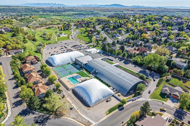

Property Detail
1221 E 5800 S
Ogden, UT
PART OF THE NORTHEAST QUARTER OF SECTION 21, TOWNSHIP 5 NORTH RANGE 1 WEST, SALT LAKE BASE AND MERIDIAN: BEGINNING AT A POINT
07-080-0031
Weber
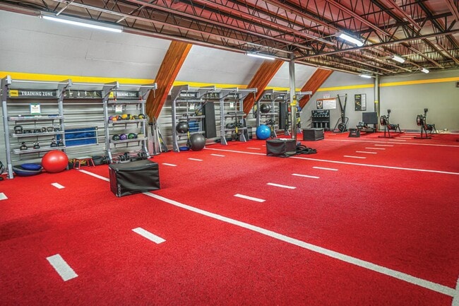
Gymhealthspa
Utah
B and X Area of moderate flood hazard, usually the area between the limits of the 100-year and 500-year floods.
25
2025
8.40 AC
2025
Davis/Weber Counties
211202
Salt Lake City
4,054 SF
NEARBY LISTINGS FOR SALE OR LEASE
DEMOGRAPHICS near 1221 E 5800 S
1 mile
3 mile
5 mile
2025 Total Population
10,426
50,567
161,697
2030 Population
10,752
52,077
168,287
Pop Growth 2025-2030
+ 3.13%
+ 2.99%
+ 4.08%
Average Age
40
37
36
2025 Total Households
4,109
17,937
57,245
HH Growth 2025-2030
+ 3.38%
+ 3.34%
+ 4.21%
Median Household Inc
$94,123
$93,090
$82,674
Avg Household Size
2.50
2.70
2.70
2025 Avg HH Vehicles
2.00
2.00
2.00
Median Home Value
$485,365
$459,622
$419,232
Median Year Built
1993
1982
1979
Nearby Places
Map Layers
Map Styles
 Street
 Aerial
Layers
 Traffic
 Biking
Places
Listings with unknown addresses are not visible on the map
- Restaurants
- Banks
- Shops
- Fitness
- Groceries
PUBLIC TRANSPORTATION
COMMUTER RAIL
Ogden (FrontRunner North - Utah Transit Authority (UTA))
Drive
Walk
Distance
Ogden (FrontRunner North - Utah Transit Authority (UTA))
13 min
6.0 mi
Roy (FrontRunner North - Utah Transit Authority (UTA))
Drive
Walk
Distance
Roy (FrontRunner North - Utah Transit Authority (UTA))
18 min
8.4 mi
AIRPORT
Salt Lake City International
Drive
Walk
Distance
Salt Lake City International
45 min
32.8 mi
Freight Ports
Port of Stockton
Drive
Walk
Distance
Port of Stockton
745 min
723.2 mi
SALE & LEASE HISTORY
LISTING DATE
SALE/LEASE

Jun 09, 2025
For Sale
Aug 16, 2023
For Sale
Nearby Properties
Address
Land Use
TOTAL SIZE
Lot Size
Zoning
Address
Land Use
TOTAL SIZE
Lot Size
Zoning
790,525 SF
57.26 AC
Address
Land Use
TOTAL SIZE
Lot Size
Zoning
13,376 SF
11.50 AC
Address
Land Use
TOTAL SIZE
Lot Size
Zoning
200,509 SF
12.75 AC
Address
Land Use
TOTAL SIZE
Lot Size
Zoning
83,038 SF
7.54 AC
Address
Land Use
TOTAL SIZE
Lot Size
Zoning
98,660 SF
3.18 AC
Address
Land Use
TOTAL SIZE
Lot Size
Zoning
4,442 SF
7.19 AC
Address
Land Use
TOTAL SIZE
Lot Size
Zoning
225,497 SF
20.33 AC
Address
Land Use
TOTAL SIZE
Lot Size
Zoning
134,796 SF
3.93 AC
Address
Land Use
TOTAL SIZE
Lot Size
Zoning
63,343 SF
16.43 AC
Address
Land Use
TOTAL SIZE
Lot Size
Zoning
73,942 SF
8.87 AC
Address
Land Use
TOTAL SIZE
Lot Size
Zoning
2,938 SF
9.69 AC
Address
Land Use
TOTAL SIZE
Lot Size
Zoning
10,440 SF
4.24 AC
Address
Land Use
TOTAL SIZE
Lot Size
Zoning
96,690 SF
1.39 AC
Address
Land Use
TOTAL SIZE
Lot Size
Zoning
134,666 SF
13.50 AC
Address
Land Use
TOTAL SIZE
Lot Size
Zoning
202,920 SF
10.16 AC
Address
Land Use
TOTAL SIZE
Lot Size
Zoning
67,248 SF
13.28 AC
Address
Land Use
TOTAL SIZE
Lot Size
Zoning
59,367 SF
5.90 AC
Address
Land Use
TOTAL SIZE
Lot Size
Zoning
2,682 SF
27.83 AC
Address
Land Use
TOTAL SIZE
Lot Size
Zoning
101,279 SF
9.70 AC
M1
Address
Land Use
TOTAL SIZE
Lot Size
Zoning
10,136 SF
2.25 AC
Address
Land Use
TOTAL SIZE
Lot Size
Zoning
4,504 SF
4.16 AC
Address
Land Use
TOTAL SIZE
Lot Size
Zoning
18,238 SF
2.74 AC
Address
Land Use
TOTAL SIZE
Lot Size
Zoning
137,716 SF
12.07 AC
Address
Land Use
TOTAL SIZE
Lot Size
Zoning
49,441 SF
1.80 AC
RM
The World's #1 Commercial Real Estate Marketplace
Connect with us
© 2026 CoStar Group
The information above has been obtained from sources believed reliable. While we do not doubt its accuracy we have not verified it and make no guarantee, warranty or representation about it. It is your responsibility to independently confirm its accuracy and completeness. Any projections, opinions, assumptions, or estimates used are for example only and do not represent the current or future performance of the property. The value of this transaction to you depends on tax and other factors which should be evaluated by your tax, financial, and legal advisors. You and your advisors should conduct a careful, independent investigation of the property to determine to your satisfaction the suitability of the property for your needs.