Property Record
1221 High Dr, Estes Park, CO 80517
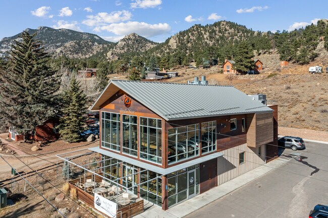

Property Detail
1221 High Dr
35352-00-027
COM AT PT WH NW COR 35-5-73 BEARS N 82 45 W 2025 FT, N 5 30 E 180 FT, S 84 10 E 100 FT, S 5 50 W 180 FT, N 84 10 W 100 FT TO BEG, EP
Commercialnec
Larimer
B and X Area of moderate flood hazard, usually the area between the limits of the 100-year and 500-year floods.
Colorado
2024
0.41 AC
2025
Outer Larimer County
002801
Denver
4,028 SF
Fort Collins-Loveland, CO
NEARBY LISTINGS FOR SALE OR LEASE
DEMOGRAPHICS near 1221 High Dr
1 mile
3 mile
5 mile
2024 Total Population
1,471
11,229
13,190
2029 Population
1,620
12,222
14,367
Pop Growth 2024-2029
+ 10.13%
+ 8.84%
+ 8.92%
Average Age
49
50
50
2024 Total Households
730
5,139
6,001
HH Growth 2024-2029
+ 10.41%
+ 9.15%
+ 9.22%
Median Household Inc
$60,095
$73,363
$76,602
Avg Household Size
2.00
2.10
2.10
2024 Avg HH Vehicles
2.00
2.00
2.00
Median Home Value
$672,500
$750,000
$753,477
Median Year Built
1972
1984
1984
Nearby Places
Map Layers
Map Styles
 Street
 Aerial
Transit
 Traffic
 Biking
Places
Listings with unknown addresses are not visible on the map
- Restaurants
- Banks
- Shops
- Fitness
- Groceries
Nearby Properties
Address
Land Use
TOTAL SIZE
Lot Size
Zoning
Address
Land Use
TOTAL SIZE
Lot Size
Zoning
793,190 SF
587.03 AC
A
Address
Land Use
TOTAL SIZE
Lot Size
Zoning
146,778 SF
34.35 AC
Address
Land Use
TOTAL SIZE
Lot Size
Zoning
142,497 SF
13.91 AC
Address
Land Use
TOTAL SIZE
Lot Size
Zoning
38,222 SF
3.53 AC
Address
Land Use
TOTAL SIZE
Lot Size
Zoning
45,000 SF
6.88 AC
Address
Land Use
TOTAL SIZE
Lot Size
Zoning
99,837 SF
3.91 AC
Address
Land Use
TOTAL SIZE
Lot Size
Zoning
88,668 SF
4.16 AC
Address
Land Use
TOTAL SIZE
Lot Size
Zoning
45,229 SF
3.80 AC
Address
Land Use
TOTAL SIZE
Lot Size
Zoning
55,690 SF
5 AC
Address
Land Use
TOTAL SIZE
Lot Size
Zoning
44,531 SF
3.33 AC
Address
Land Use
TOTAL SIZE
Lot Size
Zoning
46,243 SF
43.03 AC
A
Address
Land Use
TOTAL SIZE
Lot Size
Zoning
51,044 SF
3.26 AC
Address
Land Use
TOTAL SIZE
Lot Size
Zoning
76,952 SF
1.95 AC
Address
Land Use
TOTAL SIZE
Lot Size
Zoning
17,933 SF
2.58 AC
Address
Land Use
TOTAL SIZE
Lot Size
Zoning
21,352 SF
4.56 AC
Address
Land Use
TOTAL SIZE
Lot Size
Zoning
24,983 SF
1.61 AC
Address
Land Use
TOTAL SIZE
Lot Size
Zoning
72,429 SF
42.10 AC
Address
Land Use
TOTAL SIZE
Lot Size
Zoning
22,800 SF
10.50 AC
Address
Land Use
TOTAL SIZE
Lot Size
Zoning
22,487 SF
80.70 AC
A
Address
Land Use
TOTAL SIZE
Lot Size
Zoning
23,803 SF
4.02 AC
Address
Land Use
TOTAL SIZE
Lot Size
Zoning
20,112 SF
1.89 AC
Address
Land Use
TOTAL SIZE
Lot Size
Zoning
27,198 SF
6 AC
RE
Address
Land Use
TOTAL SIZE
Lot Size
Zoning
43,004 SF
4.19 AC
Address
Land Use
TOTAL SIZE
Lot Size
Zoning
61,320 SF
5.87 AC
Address
Land Use
TOTAL SIZE
Lot Size
Zoning
19,308 SF
1.34 AC
Address
Land Use
TOTAL SIZE
Lot Size
Zoning
21,351 SF
28.90 AC
Address
Land Use
TOTAL SIZE
Lot Size
Zoning
17,218 SF
2.47 AC
Address
Land Use
TOTAL SIZE
Lot Size
Zoning
7,495 SF
49 AC
Address
Land Use
TOTAL SIZE
Lot Size
Zoning
29,800 SF
1.55 AC
Address
Land Use
TOTAL SIZE
Lot Size
Zoning
23,362 SF
5.54 AC
The World's #1 Commercial Real Estate Marketplace
Connect with us
© 2026 CoStar Group
The information above has been obtained from sources believed reliable. While we do not doubt its accuracy we have not verified it and make no guarantee, warranty or representation about it. It is your responsibility to independently confirm its accuracy and completeness. Any projections, opinions, assumptions, or estimates used are for example only and do not represent the current or future performance of the property. The value of this transaction to you depends on tax and other factors which should be evaluated by your tax, financial, and legal advisors. You and your advisors should conduct a careful, independent investigation of the property to determine to your satisfaction the suitability of the property for your needs.