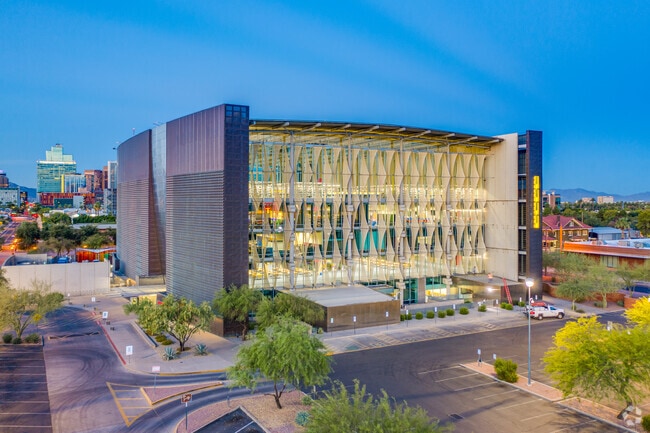
Property Record
1221 N Central Ave, Phoenix, AZ 85004


Save to a Folder
{{folder.Name}}
{{folder.ListingIds.length}} Properties
{{folder.ListingIds.length}} Property
Create a New Folder
Property Detail
1221 N Central Ave
111-35-104
NEW PHOENIX CENTRAL LIBRARY MCR 362-32
Municipalproperty
Maricopa
DTC-GTWY
Arizona
C and X Area of minimal flood hazard, usually depicted on FIRMs as above the 500-year flood level.
1
0
5.34 AC
2025
Midtown
113000
Phoenix
269,101 SF
Phoenix-Mesa-Chandler, AZ
NEARBY LISTINGS FOR SALE OR LEASE
DEMOGRAPHICS near 1221 N Central Ave
1 mile
3 mile
5 mile
2025 Total Population
23,334
140,793
396,672
2030 Population
25,023
148,154
414,261
Pop Growth 2025-2030
+ 7.24%
+ 5.23%
+ 4.43%
Average Age
38
37
36
2025 Total Households
12,586
59,265
151,695
HH Growth 2025-2030
+ 7.71%
+ 5.50%
+ 4.77%
Median Household Inc
$70,713
$62,845
$63,600
Avg Household Size
1.70
2.20
2.40
2025 Avg HH Vehicles
1.00
1.00
2.00
Median Home Value
$632,790
$457,721
$425,773
Median Year Built
1986
1969
1971
Nearby Places
Map Layers
Map Styles
 Street
 Aerial
Layers
 Traffic
 Biking
Places
Listings with unknown addresses are not visible on the map
- Restaurants
- Banks
- Shops
- Fitness
- Groceries
PUBLIC TRANSPORTATION
TRANSIT/SUBWAY
Mcdowell/Central Ave (METRO Light Rail - Valley Metro (Phoenix Light Rail))
Drive
Walk
Distance
Mcdowell/Central Ave (METRO Light Rail - Valley Metro (Phoenix Light Rail))
1 min
4 min
0.2 mi
Roosevelt/Central Ave (METRO Light Rail - Valley Metro (Phoenix Light Rail))
Drive
Walk
Distance
Roosevelt/Central Ave (METRO Light Rail - Valley Metro (Phoenix Light Rail))
3 min
6 min
0.4 mi
Encanto/Central Ave (METRO Light Rail - Valley Metro (Phoenix Light Rail))
Drive
Walk
Distance
Encanto/Central Ave (METRO Light Rail - Valley Metro (Phoenix Light Rail))
2 min
15 min
0.8 mi
Van Buren/Central Ave (METRO Light Rail - Valley Metro (Phoenix Light Rail))
Drive
Walk
Distance
Van Buren/Central Ave (METRO Light Rail - Valley Metro (Phoenix Light Rail))
3 min
16 min
0.9 mi
Van Buren/1St Ave (METRO Light Rail - Valley Metro (Phoenix Light Rail))
Drive
Walk
Distance
Van Buren/1St Ave (METRO Light Rail - Valley Metro (Phoenix Light Rail))
3 min
17 min
0.9 mi
AIRPORT
Phoenix Sky Harbor International
Drive
Walk
Distance
Phoenix Sky Harbor International
12 min
6.3 mi
Phoenix-Mesa Gateway
Drive
Walk
Distance
Phoenix-Mesa Gateway
44 min
33.1 mi
Freight Ports
Port of San Diego
Drive
Walk
Distance
Port of San Diego
396 min
355.8 mi
Nearby Properties
Address
Land Use
TOTAL SIZE
Lot Size
Zoning
Address
Land Use
TOTAL SIZE
Lot Size
Zoning
582,073 SF
1.45 AC
C-C
Address
Land Use
TOTAL SIZE
Lot Size
Zoning
1.85 AC
Address
Land Use
TOTAL SIZE
Lot Size
Zoning
455,443 SF
3.21 AC
C-C
Address
Land Use
TOTAL SIZE
Lot Size
Zoning
997,436 SF
24.84 AC
DC
Address
Land Use
TOTAL SIZE
Lot Size
Zoning
24.15 AC
Address
Land Use
TOTAL SIZE
Lot Size
Zoning
339,909 SF
3 AC
C-C
Address
Land Use
TOTAL SIZE
Lot Size
Zoning
2,568,761 SF
48.36 AC
C-C
Address
Land Use
TOTAL SIZE
Lot Size
Zoning
437,102 SF
1.02 AC
C-2
Address
Land Use
TOTAL SIZE
Lot Size
Zoning
2,006,402 SF
18.66 AC
C-C
Address
Land Use
TOTAL SIZE
Lot Size
Zoning
2,334,671 SF
32.63 AC
C-2
Address
Land Use
TOTAL SIZE
Lot Size
Zoning
191,120 SF
1.43 AC
C-C
Address
Land Use
TOTAL SIZE
Lot Size
Zoning
1,636,025 SF
16.50 AC
C-DT
Address
Land Use
TOTAL SIZE
Lot Size
Zoning
1,748,324 SF
29.35 AC
M-H
Address
Land Use
TOTAL SIZE
Lot Size
Zoning
2,705,875 SF
133.42 AC
I-1
Address
Land Use
TOTAL SIZE
Lot Size
Zoning
577,883 SF
2.05 AC
C-DT
Address
Land Use
TOTAL SIZE
Lot Size
Zoning
568,512 SF
6.99 AC
C-DT
Address
Land Use
TOTAL SIZE
Lot Size
Zoning
671,803 SF
2.99 AC
C-DT
Address
Land Use
TOTAL SIZE
Lot Size
Zoning
833,326 SF
1.31 AC
C-DT
Address
Land Use
TOTAL SIZE
Lot Size
Zoning
940,067 SF
12.22 AC
DTCBIO
Address
Land Use
TOTAL SIZE
Lot Size
Zoning
536,452 SF
0.58 AC
C-DT
Address
Land Use
TOTAL SIZE
Lot Size
Zoning
981,015 SF
2.83 AC
C-DT
Address
Land Use
TOTAL SIZE
Lot Size
Zoning
429,457 SF
9.41 AC
C-DT
Address
Land Use
TOTAL SIZE
Lot Size
Zoning
384,291 SF
2.68 AC
C-DT
Address
Land Use
TOTAL SIZE
Lot Size
Zoning
925,428 SF
86.02 AC
M-H
Address
Land Use
TOTAL SIZE
Lot Size
Zoning
782,912 SF
1.12 AC
C-DT
Address
Land Use
TOTAL SIZE
Lot Size
Zoning
550,269 SF
2.05 AC
DTCBCORE
Address
Land Use
TOTAL SIZE
Lot Size
Zoning
727,848 SF
0.06 AC
C-DT
Address
Land Use
TOTAL SIZE
Lot Size
Zoning
913,637 SF
35.53 AC
M-H
Address
Land Use
TOTAL SIZE
Lot Size
Zoning
569,100 SF
0.95 AC
C-DT
Address
Land Use
TOTAL SIZE
Lot Size
Zoning
222,983 SF
1.61 AC
C-DT
The World's #1 Commercial Real Estate Marketplace
Connect with us
© 2026 CoStar Group
The information above has been obtained from sources believed reliable. While we do not doubt its accuracy we have not verified it and make no guarantee, warranty or representation about it. It is your responsibility to independently confirm its accuracy and completeness. Any projections, opinions, assumptions, or estimates used are for example only and do not represent the current or future performance of the property. The value of this transaction to you depends on tax and other factors which should be evaluated by your tax, financial, and legal advisors. You and your advisors should conduct a careful, independent investigation of the property to determine to your satisfaction the suitability of the property for your needs.