Property Record
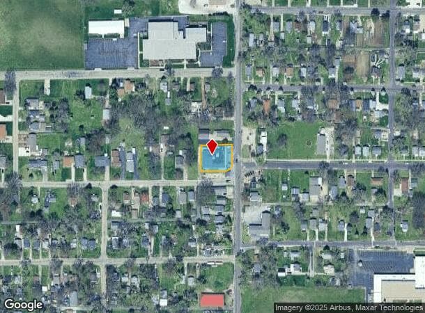
1221 S Laramie St, Peoria, IL 61605
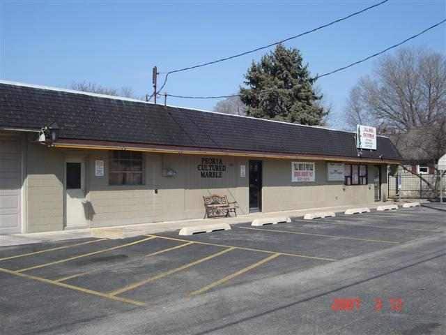
This Property Is For Sale
NEARBY LISTINGS FOR SALE OR LEASE
Property Detail
1221 S Laramie St
Peoria
Tinans Sub
Peoria, IL
TINANS SUB NE 1/4 SEC 13-8N-7E LOTS 1-2 & S 26 LOT 3
17-13-280-034
Peoria
Commercialnec
Illinois
2024
1-2,3
2024
0.34 AC
004802
South Peoria
DEMOGRAPHICS near 1221 S Laramie St
1 Mile
3 Mile
5 Mile
2024 Total Population
8,938
43,505
100,604
2029 Population
8,965
42,986
99,025
Pop Growth 2024-2029
+ 0.30%
(1.19%)
(1.57%)
Average Age
37
38
39
2024 Total Households
3,475
17,994
41,934
HH Growth 2024-2029
(0.06%)
(1.45%)
(1.80%)
Median Household Inc
$32,766
$43,027
$45,337
Avg Household Size
2.40
2.20
2.20
2024 Avg HH Vehicles
1.00
1.00
2.00
Median Home Value
$57,269
$84,694
$94,720
Median Year Built
1950
1953
1954
Nearby Places
Map Layers
Map Styles
 Street
 Aerial
- Restaurants
- Banks
- Shops
- Fitness
- Groceries
PUBLIC TRANSPORTATION
AIRPORT
General Downing - Peoria International
DRIVE
WALK
Distance
General Downing - Peoria International
11 min
4.1 mi
Nearby Properties
Address
Land Use
TOTAL SIZE
Lot Size
Zoning
Address
Land Use
TOTAL SIZE
Lot Size
Zoning
232,535 SF
3.45 AC
Address
Land Use
TOTAL SIZE
Lot Size
Zoning
0.91 AC
Address
Land Use
TOTAL SIZE
Lot Size
Zoning
Address
Land Use
TOTAL SIZE
Lot Size
Zoning
Address
Land Use
TOTAL SIZE
Lot Size
Zoning
49.61 AC
Address
Land Use
TOTAL SIZE
Lot Size
Zoning
80 SF
14.30 AC
Address
Land Use
TOTAL SIZE
Lot Size
Zoning
0.57 AC
Address
Land Use
TOTAL SIZE
Lot Size
Zoning
0.44 AC
Address
Land Use
TOTAL SIZE
Lot Size
Zoning
161,535 SF
4.76 AC
Address
Land Use
TOTAL SIZE
Lot Size
Zoning
132.43 AC
Address
Land Use
TOTAL SIZE
Lot Size
Zoning
51,190 SF
3.74 AC
Address
Land Use
TOTAL SIZE
Lot Size
Zoning
21.18 AC
Address
Land Use
TOTAL SIZE
Lot Size
Zoning
12.12 AC
Address
Land Use
TOTAL SIZE
Lot Size
Zoning
Address
Land Use
TOTAL SIZE
Lot Size
Zoning
0.89 AC
Address
Land Use
TOTAL SIZE
Lot Size
Zoning
28.18 AC
Address
Land Use
TOTAL SIZE
Lot Size
Zoning
Address
Land Use
TOTAL SIZE
Lot Size
Zoning
Address
Land Use
TOTAL SIZE
Lot Size
Zoning
0.48 AC
Address
Land Use
TOTAL SIZE
Lot Size
Zoning
0.57 AC
Address
Land Use
TOTAL SIZE
Lot Size
Zoning
1.17 AC
Address
Land Use
TOTAL SIZE
Lot Size
Zoning
48.70 AC
Address
Land Use
TOTAL SIZE
Lot Size
Zoning
46.65 AC
Address
Land Use
TOTAL SIZE
Lot Size
Zoning
Address
Land Use
TOTAL SIZE
Lot Size
Zoning
0.48 AC
Address
Land Use
TOTAL SIZE
Lot Size
Zoning
10.89 AC
Address
Land Use
TOTAL SIZE
Lot Size
Zoning
Address
Land Use
TOTAL SIZE
Lot Size
Zoning
Address
Land Use
TOTAL SIZE
Lot Size
Zoning
5.81 AC
Address
Land Use
TOTAL SIZE
Lot Size
Zoning
The World's #1 Commercial Real Estate Marketplace
Connect with us
© 2025 CoStar Group
The information above has been obtained from sources believed reliable. While we do not doubt its accuracy we have not verified it and make no guarantee, warranty or representation about it. It is your responsibility to independently confirm its accuracy and completeness. Any projections, opinions, assumptions, or estimates used are for example only and do not represent the current or future performance of the property. The value of this transaction to you depends on tax and other factors which should be evaluated by your tax, financial, and legal advisors. You and your advisors should conduct a careful, independent investigation of the property to determine to your satisfaction the suitability of the property for your needs.