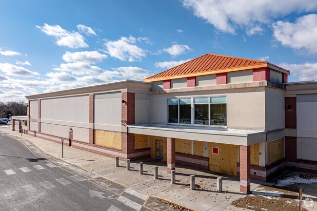
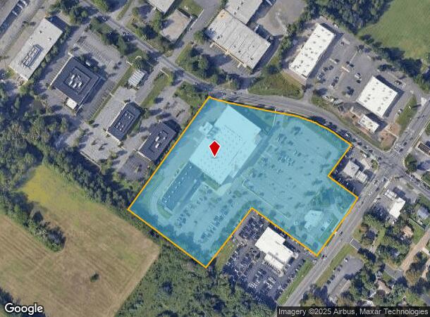
Property Record
1221 State Route 27, Somerset, NJ 08873
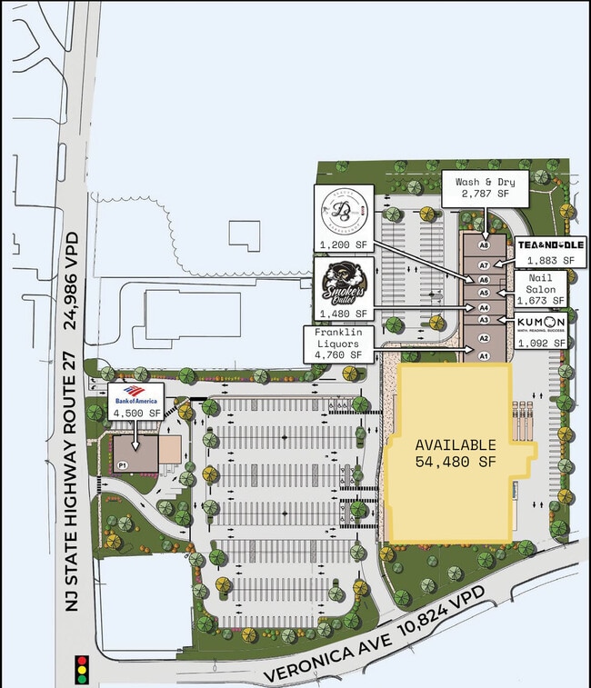
Current Lease Availabilities
NEARBY LISTINGS FOR SALE OR LEASE
Property Detail
1221 State Route 27
08-00088-02-00090-01
Hyland Indust Park
Regionalshoppingcenterormallwithanchorstore
Somerset
X
New Jersey
34023C0126F
90.1
2024
9.54 AC
2025
Princeton North
372900
Northern New Jersey
9,100 SF
Newark, NJ-PA
DEMOGRAPHICS near 1221 State Route 27
1 Mile
3 Mile
5 Mile
2024 Total Population
8,787
123,739
228,876
2029 Population
8,805
122,673
227,925
Pop Growth 2024-2029
+ 0.20%
(0.86%)
(0.42%)
Average Age
38
37
38
2024 Total Households
2,981
40,189
77,970
HH Growth 2024-2029
+ 0.07%
(0.63%)
(0.29%)
Median Household Inc
$88,869
$86,542
$96,067
Avg Household Size
2.90
2.80
2.70
2024 Avg HH Vehicles
2.00
2.00
2.00
Median Home Value
$399,887
$364,506
$397,634
Median Year Built
1980
1976
1977
Nearby Places
Map Layers
Map Styles
 Street
 Aerial
- Restaurants
- Banks
- Shops
- Fitness
- Groceries
PUBLIC TRANSPORTATION
COMMUTER RAIL
Jersey Avenue (Northeast Corridor Line - NJ Transit Commuter Rail (NJ Transit))
DRIVE
WALK
Distance
Jersey Avenue (Northeast Corridor Line - NJ Transit Commuter Rail (NJ Transit))
8 min
1.9 mi
New Brunswick (Northeast Corridor Line - NJ Transit Commuter Rail (NJ Transit))
DRIVE
WALK
Distance
New Brunswick (Northeast Corridor Line - NJ Transit Commuter Rail (NJ Transit))
7 min
3.1 mi
AIRPORT
Trenton Mercer
DRIVE
WALK
Distance
Trenton Mercer
39 min
26.2 mi
Newark Liberty International
DRIVE
WALK
Distance
Newark Liberty International
43 min
31.5 mi
LaGuardia
DRIVE
WALK
Distance
LaGuardia
75 min
48.3 mi
Freight Ports
New York Container Terminal
DRIVE
WALK
Distance
New York Container Terminal
38 min
24.3 mi
Nearby Properties
Address
Land Use
TOTAL SIZE
Lot Size
Zoning
Address
Land Use
TOTAL SIZE
Lot Size
Zoning
8.25 AC
D-HI
Address
Land Use
TOTAL SIZE
Lot Size
Zoning
Address
Land Use
TOTAL SIZE
Lot Size
Zoning
25.77 AC
C-6
Address
Land Use
TOTAL SIZE
Lot Size
Zoning
11.50 AC
HI
Address
Land Use
TOTAL SIZE
Lot Size
Zoning
99.79 AC
B-I
Address
Land Use
TOTAL SIZE
Lot Size
Zoning
77.04 AC
I2
Address
Land Use
TOTAL SIZE
Lot Size
Zoning
21.30 AC
IN-1
Address
Land Use
TOTAL SIZE
Lot Size
Zoning
48.30 AC
GB
Address
Land Use
TOTAL SIZE
Lot Size
Zoning
31.07 AC
ERR
Address
Land Use
TOTAL SIZE
Lot Size
Zoning
543,945 SF
48.46 AC
B-I
Address
Land Use
TOTAL SIZE
Lot Size
Zoning
1.15 AC
C-4
Address
Land Use
TOTAL SIZE
Lot Size
Zoning
0.25 AC
C-4
Address
Land Use
TOTAL SIZE
Lot Size
Zoning
18.21 AC
E
Address
Land Use
TOTAL SIZE
Lot Size
Zoning
0.92 AC
D-HI
Address
Land Use
TOTAL SIZE
Lot Size
Zoning
1.81 AC
D-HI
Address
Land Use
TOTAL SIZE
Lot Size
Zoning
11.35 AC
R20
Address
Land Use
TOTAL SIZE
Lot Size
Zoning
Address
Land Use
TOTAL SIZE
Lot Size
Zoning
34.75 AC
CR
Address
Land Use
TOTAL SIZE
Lot Size
Zoning
Address
Land Use
TOTAL SIZE
Lot Size
Zoning
Address
Land Use
TOTAL SIZE
Lot Size
Zoning
1,200 SF
0.01 AC
D-HI
Address
Land Use
TOTAL SIZE
Lot Size
Zoning
27.23 AC
CR
Address
Land Use
TOTAL SIZE
Lot Size
Zoning
Address
Land Use
TOTAL SIZE
Lot Size
Zoning
Address
Land Use
TOTAL SIZE
Lot Size
Zoning
3,250 SF
1.52 AC
IN-1
Address
Land Use
TOTAL SIZE
Lot Size
Zoning
4.89 AC
R-7
Address
Land Use
TOTAL SIZE
Lot Size
Zoning
8,430 SF
10.51 AC
I-2
Address
Land Use
TOTAL SIZE
Lot Size
Zoning
46.85 AC
ERR
Address
Land Use
TOTAL SIZE
Lot Size
Zoning
283,080 SF
34.62 AC
CR
Address
Land Use
TOTAL SIZE
Lot Size
Zoning
The World's #1 Commercial Real Estate Marketplace
Connect with us
© 2025 CoStar Group
The information above has been obtained from sources believed reliable. While we do not doubt its accuracy we have not verified it and make no guarantee, warranty or representation about it. It is your responsibility to independently confirm its accuracy and completeness. Any projections, opinions, assumptions, or estimates used are for example only and do not represent the current or future performance of the property. The value of this transaction to you depends on tax and other factors which should be evaluated by your tax, financial, and legal advisors. You and your advisors should conduct a careful, independent investigation of the property to determine to your satisfaction the suitability of the property for your needs.