Property Record
1221 Wilson Rd, Glen Burnie, MD 21061

NEARBY LISTINGS FOR SALE OR LEASE
Property Detail
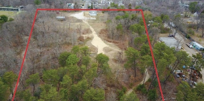
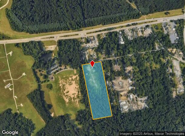
1221 Wilson Rd
Baltimore-Columbia-Towson, MD
Glenbrook
05-322-17970400
LT A OR 10 ACRES GLENBROOK
Officebuilding
Anne Arundel
X
Maryland
24003C0042E
a
2024
10 AC
2025
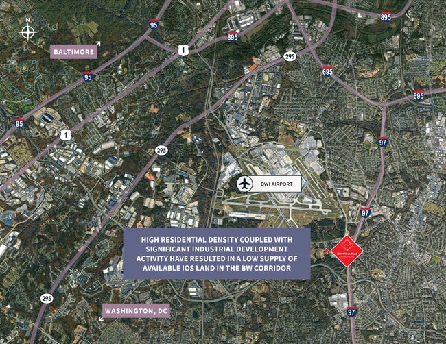
BWI/Anne Arundel
751400
Baltimore
2,752 SF
DEMOGRAPHICS near 1221 Wilson Rd
1 Mile
3 Mile
5 Mile
2024 Total Population
2,269
74,345
196,051
2029 Population
2,316
75,770
200,893
Pop Growth 2024-2029
+ 2.07%
+ 1.92%
+ 2.47%
Average Age
40
40
39
2024 Total Households
824
28,058
73,145
HH Growth 2024-2029
+ 2.18%
+ 1.93%
+ 2.55%
Median Household Inc
$101,059
$85,509
$97,000
Avg Household Size
2.70
2.60
2.60
2024 Avg HH Vehicles
2.00
2.00
2.00
Median Home Value
$292,682
$323,197
$351,004
Median Year Built
1969
1971
1981
Nearby Places
- Restaurants
- Banks
- Shops
- Fitness
- Groceries
PUBLIC TRANSPORTATION
COMMUTER RAIL
Bwi Airport (Penn Line - Maryland Area Regional Commuter Trains (The MARC))
DRIVE
WALK
Distance
Bwi Airport (Penn Line - Maryland Area Regional Commuter Trains (The MARC))
9 min
5.0 mi
St Denis (Camden Line - Maryland Area Regional Commuter Trains (The MARC))
DRIVE
WALK
Distance
St Denis (Camden Line - Maryland Area Regional Commuter Trains (The MARC))
13 min
7.5 mi
AIRPORT
Baltimore/Washington International Thurgood Marshall
DRIVE
WALK
Distance
Baltimore/Washington International Thurgood Marshall
9 min
4.8 mi
Ronald Reagan Washington Ntl
DRIVE
WALK
Distance
Ronald Reagan Washington Ntl
56 min
36.5 mi
Freight Ports
Port of Baltimore
DRIVE
WALK
Distance
Port of Baltimore
19 min
11.4 mi
SALE & LEASE HISTORY
LISTING DATE
SALE/LEASE

Jun 05, 2017
For Sale
Jul 18, 2022
For Lease
Jan 04, 2022
For Lease
Nearby Properties
Address
Land Use
TOTAL SIZE
Lot Size
Zoning
Address
Land Use
TOTAL SIZE
Lot Size
Zoning
637,060 SF
22.19 AC
C2
Address
Land Use
TOTAL SIZE
Lot Size
Zoning
312,489 SF
9.04 AC
C3
Address
Land Use
TOTAL SIZE
Lot Size
Zoning
356,600 SF
21.37 AC
R5
Address
Land Use
TOTAL SIZE
Lot Size
Zoning
383,697 SF
68.35 AC
R5
Address
Land Use
TOTAL SIZE
Lot Size
Zoning
60,200 SF
778.66 AC
R1
Address
Land Use
TOTAL SIZE
Lot Size
Zoning
11.57 AC
R22
Address
Land Use
TOTAL SIZE
Lot Size
Zoning
778.66 AC
R1
Address
Land Use
TOTAL SIZE
Lot Size
Zoning
292,269 SF
15.86 AC
W1-BW
Address
Land Use
TOTAL SIZE
Lot Size
Zoning
28.02 AC
R15
Address
Land Use
TOTAL SIZE
Lot Size
Zoning
19.20 AC
R15
Address
Land Use
TOTAL SIZE
Lot Size
Zoning
1,489,438 SF
74.22 AC
W2
Address
Land Use
TOTAL SIZE
Lot Size
Zoning
14.21 AC
R15
Address
Land Use
TOTAL SIZE
Lot Size
Zoning
1,555.10 AC
R1
Address
Land Use
TOTAL SIZE
Lot Size
Zoning
15.33 AC
R15
Address
Land Use
TOTAL SIZE
Lot Size
Zoning
21.45 AC
R15
Address
Land Use
TOTAL SIZE
Lot Size
Zoning
14.53 AC
R22
Address
Land Use
TOTAL SIZE
Lot Size
Zoning
14.58 AC
R22
Address
Land Use
TOTAL SIZE
Lot Size
Zoning
5.95 AC
R22
Address
Land Use
TOTAL SIZE
Lot Size
Zoning
277,203 SF
15.88 AC
R15
Address
Land Use
TOTAL SIZE
Lot Size
Zoning
9.45 AC
R22
Address
Land Use
TOTAL SIZE
Lot Size
Zoning
187,814 SF
38.47 AC
R5
Address
Land Use
TOTAL SIZE
Lot Size
Zoning
204,000 SF
7.70 AC
W1-BW
Address
Land Use
TOTAL SIZE
Lot Size
Zoning
10.92 AC
R15
Address
Land Use
TOTAL SIZE
Lot Size
Zoning
218,565 SF
20.87 AC
C3
Address
Land Use
TOTAL SIZE
Lot Size
Zoning
8.78 AC
R15
Address
Land Use
TOTAL SIZE
Lot Size
Zoning
0.34 AC
R22
Address
Land Use
TOTAL SIZE
Lot Size
Zoning
13.03 AC
R15
Address
Land Use
TOTAL SIZE
Lot Size
Zoning
28,188 SF
6.51 AC
C3
Address
Land Use
TOTAL SIZE
Lot Size
Zoning
209,044 SF
17.28 AC
C3
Address
Land Use
TOTAL SIZE
Lot Size
Zoning
295,059 SF
14.40 AC
W2
The World's #1 Commercial Real Estate Marketplace
Connect with us
© 2025 CoStar Group
The information above has been obtained from sources believed reliable. While we do not doubt its accuracy we have not verified it and make no guarantee, warranty or representation about it. It is your responsibility to independently confirm its accuracy and completeness. Any projections, opinions, assumptions, or estimates used are for example only and do not represent the current or future performance of the property. The value of this transaction to you depends on tax and other factors which should be evaluated by your tax, financial, and legal advisors. You and your advisors should conduct a careful, independent investigation of the property to determine to your satisfaction the suitability of the property for your needs.