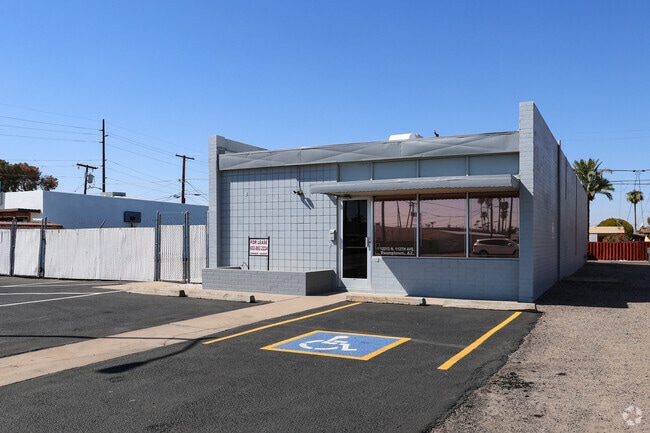
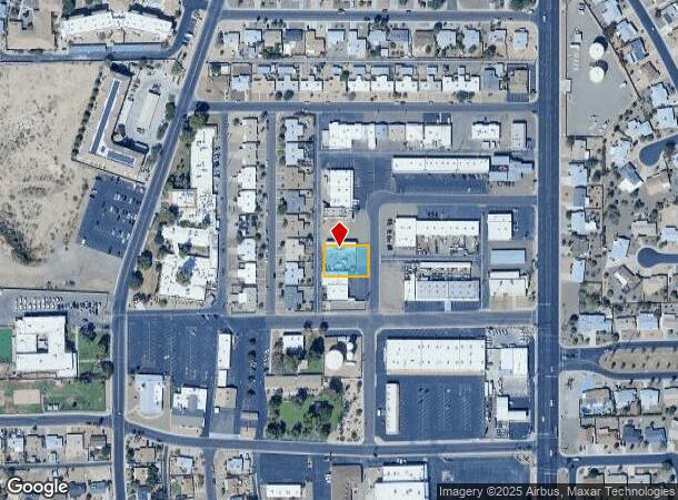
Property Record
12212 N 112Th Ave, Youngtown, AZ 85363

NEARBY LISTINGS FOR SALE OR LEASE
-
-
-
-
-
No Photo
-
-
-
View all Youngtown listings for lease on LoopNet.com
Property Detail
12212 N 112Th Ave
Phoenix-Mesa-Scottsdale, AZ
Youngtown Park
200-85-363
YOUNGTOWN PARK MCR 100-12
Storebuilding
Maricopa
X
Arizona
04013C1685M
7
2025
0.27 AC
2025
Sun City
071600
Phoenix
2,640 SF
DEMOGRAPHICS near 12212 N 112Th Ave
1 Mile
3 Mile
5 Mile
2024 Total Population
14,084
96,189
243,996
2029 Population
15,256
104,007
264,876
Pop Growth 2024-2029
+ 8.32%
+ 8.13%
+ 8.56%
Average Age
47
47
45
2024 Total Households
6,323
40,797
97,829
HH Growth 2024-2029
+ 8.76%
+ 8.44%
+ 8.72%
Median Household Inc
$44,380
$54,013
$63,202
Avg Household Size
2.20
2.30
2.40
2024 Avg HH Vehicles
2.00
2.00
2.00
Median Home Value
$193,236
$240,507
$284,340
Median Year Built
1972
1978
1990
Nearby Places
Map Layers
Map Styles
 Street
 Aerial
- Restaurants
- Banks
- Shops
- Fitness
- Groceries
PUBLIC TRANSPORTATION
AIRPORT
Phoenix Sky Harbor International
DRIVE
WALK
Distance
Phoenix Sky Harbor International
41 min
30.1 mi
Freight Ports
Port of San Diego
DRIVE
WALK
Distance
Port of San Diego
397 min
350.8 mi
SALE & LEASE HISTORY
LISTING DATE
SALE/LEASE

Oct 06, 2024
For Lease
May 22, 2019
For Sale
Jul 02, 2019
For Lease
Nearby Properties
Address
Land Use
TOTAL SIZE
Lot Size
Zoning
Address
Land Use
TOTAL SIZE
Lot Size
Zoning
138.98 AC
Address
Land Use
TOTAL SIZE
Lot Size
Zoning
35.74 AC
Address
Land Use
TOTAL SIZE
Lot Size
Zoning
303,419 SF
31.47 AC
Address
Land Use
TOTAL SIZE
Lot Size
Zoning
1,010,365 SF
29.94 AC
C2
Address
Land Use
TOTAL SIZE
Lot Size
Zoning
53.02 AC
Address
Land Use
TOTAL SIZE
Lot Size
Zoning
1,113,127 SF
48.24 AC
C2
Address
Land Use
TOTAL SIZE
Lot Size
Zoning
547,083 SF
10.94 AC
C-C
Address
Land Use
TOTAL SIZE
Lot Size
Zoning
294,360 SF
21.69 AC
EI
Address
Land Use
TOTAL SIZE
Lot Size
Zoning
225,457 SF
70.07 AC
PAD
Address
Land Use
TOTAL SIZE
Lot Size
Zoning
318,282 SF
15.23 AC
PAD
Address
Land Use
TOTAL SIZE
Lot Size
Zoning
20,948 SF
2.39 AC
R-6
Address
Land Use
TOTAL SIZE
Lot Size
Zoning
327,311 SF
21.14 AC
RM-1
Address
Land Use
TOTAL SIZE
Lot Size
Zoning
418,305 SF
24.06 AC
PAD
Address
Land Use
TOTAL SIZE
Lot Size
Zoning
247,178 SF
33.92 AC
PAD
Address
Land Use
TOTAL SIZE
Lot Size
Zoning
106,356 SF
14.16 AC
PAD
Address
Land Use
TOTAL SIZE
Lot Size
Zoning
77,400 SF
20.34 AC
PAD
Address
Land Use
TOTAL SIZE
Lot Size
Zoning
707,380 SF
46.26 AC
I-2
Address
Land Use
TOTAL SIZE
Lot Size
Zoning
67,932 SF
14.90 AC
PAD
Address
Land Use
TOTAL SIZE
Lot Size
Zoning
199,390 SF
24.59 AC
C-C
Address
Land Use
TOTAL SIZE
Lot Size
Zoning
116,323 SF
17.38 AC
R-8
Address
Land Use
TOTAL SIZE
Lot Size
Zoning
262,295 SF
14.79 AC
M-M
Address
Land Use
TOTAL SIZE
Lot Size
Zoning
66,510 SF
4.36 AC
Address
Land Use
TOTAL SIZE
Lot Size
Zoning
112,957 SF
17.40 AC
PAD
Address
Land Use
TOTAL SIZE
Lot Size
Zoning
123,820 SF
4.53 AC
C-C
Address
Land Use
TOTAL SIZE
Lot Size
Zoning
19,858 SF
0.64 AC
C-2
Address
Land Use
TOTAL SIZE
Lot Size
Zoning
50,601 SF
3.71 AC
PUD
Address
Land Use
TOTAL SIZE
Lot Size
Zoning
163,595 SF
17.52 AC
PAD
Address
Land Use
TOTAL SIZE
Lot Size
Zoning
Address
Land Use
TOTAL SIZE
Lot Size
Zoning
7,052 SF
0.61 AC
C-C
Address
Land Use
TOTAL SIZE
Lot Size
Zoning
92,226 SF
7.54 AC
C-C
The World's #1 Commercial Real Estate Marketplace
Connect with us
© 2025 CoStar Group
The information above has been obtained from sources believed reliable. While we do not doubt its accuracy we have not verified it and make no guarantee, warranty or representation about it. It is your responsibility to independently confirm its accuracy and completeness. Any projections, opinions, assumptions, or estimates used are for example only and do not represent the current or future performance of the property. The value of this transaction to you depends on tax and other factors which should be evaluated by your tax, financial, and legal advisors. You and your advisors should conduct a careful, independent investigation of the property to determine to your satisfaction the suitability of the property for your needs.