Property Record
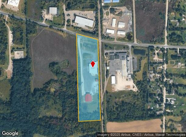
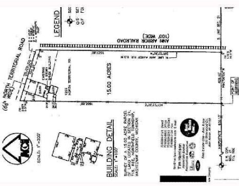
1222 E North Territorial Rd, Whitmore Lake, MI 48189

NEARBY LISTINGS FOR SALE OR LEASE
Property Detail
1222 E North Territorial Rd
02-21-300-004
TRANS 1/6/96 OLD SID: B02-021-019-00 NO 21-9B COM AT SW COR OF SEC, TH E 939.13 FT IN S LINE OF SEC TO POB, TH N 1-22-30 E
Commercialnec
Washtenaw
X
Michigan
26161C0113E
15 AC
0
Washtenaw E of 23
2025
Detroit
465002
Ann Arbor, MI
2,375 SF
DEMOGRAPHICS near 1222 E North Territorial Rd
1 Mile
3 Mile
5 Mile
2024 Total Population
257
4,511
31,372
2029 Population
253
4,430
31,484
Pop Growth 2024-2029
(1.56%)
(1.80%)
+ 0.36%
Average Age
43
42
41
2024 Total Households
97
1,766
12,550
HH Growth 2024-2029
(2.06%)
(1.93%)
+ 0.28%
Median Household Inc
$99,999
$95,896
$95,795
Avg Household Size
2.60
2.50
2.40
2024 Avg HH Vehicles
2.00
2.00
2.00
Median Home Value
$413,333
$339,117
$369,559
Median Year Built
1979
1988
1988
Nearby Places
Map Layers
Map Styles
 Street
 Aerial
- Restaurants
- Banks
- Shops
- Fitness
- Groceries
PUBLIC TRANSPORTATION
COMMUTER RAIL
Ann Arbor Amtrak Station (Wolverine - Amtrak)
DRIVE
WALK
Distance
Ann Arbor Amtrak Station (Wolverine - Amtrak)
11 min
7.9 mi
AIRPORT
Detroit Metro Wayne County
DRIVE
WALK
Distance
Detroit Metro Wayne County
43 min
35.2 mi
Freight Ports
Port of Toledo
DRIVE
WALK
Distance
Port of Toledo
85 min
68.2 mi
Nearby Properties
Address
Land Use
TOTAL SIZE
Lot Size
Zoning
Address
Land Use
TOTAL SIZE
Lot Size
Zoning
291,012 SF
70.69 AC
P.U.D
Address
Land Use
TOTAL SIZE
Lot Size
Zoning
291,012 SF
Address
Land Use
TOTAL SIZE
Lot Size
Zoning
32,964 SF
11.95 AC
MR-MULTIPL
Address
Land Use
TOTAL SIZE
Lot Size
Zoning
12,000 SF
26.97 AC
GI-GEN IND
Address
Land Use
TOTAL SIZE
Lot Size
Zoning
62,548 SF
4.28 AC
GC-GEN COM
Address
Land Use
TOTAL SIZE
Lot Size
Zoning
41.13 AC
GC-GEN COM
Address
Land Use
TOTAL SIZE
Lot Size
Zoning
65.46 AC
GC-GEN COM
Address
Land Use
TOTAL SIZE
Lot Size
Zoning
50,733 SF
12.51 AC
RTM-RESEAR
Address
Land Use
TOTAL SIZE
Lot Size
Zoning
70.16 AC
PSC-PLANNE
Address
Land Use
TOTAL SIZE
Lot Size
Zoning
29,190 SF
19.97 AC
RTM-RESEAR
Address
Land Use
TOTAL SIZE
Lot Size
Zoning
49,834 SF
8 AC
RTM-RESEAR
Address
Land Use
TOTAL SIZE
Lot Size
Zoning
35,119 SF
RTM-RESEAR
Address
Land Use
TOTAL SIZE
Lot Size
Zoning
35.74 AC
GC-GEN COM
Address
Land Use
TOTAL SIZE
Lot Size
Zoning
14,162 SF
158.28 AC
AR-AGRICUL
Address
Land Use
TOTAL SIZE
Lot Size
Zoning
80.21 AC
R-6
Address
Land Use
TOTAL SIZE
Lot Size
Zoning
22,676 SF
5.30 AC
GC-GEN COM
Address
Land Use
TOTAL SIZE
Lot Size
Zoning
3,800 SF
5.53 AC
GC-GEN COM
Address
Land Use
TOTAL SIZE
Lot Size
Zoning
16,488 SF
10.02 AC
LI-LTD IND
Address
Land Use
TOTAL SIZE
Lot Size
Zoning
9,600 SF
10.13 AC
LI-LTD IND
Address
Land Use
TOTAL SIZE
Lot Size
Zoning
91.51 AC
LR-2AC
Address
Land Use
TOTAL SIZE
Lot Size
Zoning
19,128 SF
5.31 AC
RTM-RESEAR
Address
Land Use
TOTAL SIZE
Lot Size
Zoning
107.44 AC
RTM-RESEAR
Address
Land Use
TOTAL SIZE
Lot Size
Zoning
41.35 AC
RTM-RESEAR
Address
Land Use
TOTAL SIZE
Lot Size
Zoning
2,655 SF
3.45 AC
GC-GEN COM
Address
Land Use
TOTAL SIZE
Lot Size
Zoning
15,400 SF
10.29 AC
AR-AGRICUL
Address
Land Use
TOTAL SIZE
Lot Size
Zoning
5,000 SF
5.84 AC
GI-GEN IND
Address
Land Use
TOTAL SIZE
Lot Size
Zoning
3,640 SF
4.97 AC
LI-LTD IND
Address
Land Use
TOTAL SIZE
Lot Size
Zoning
9,120 SF
9.79 AC
GC-GEN COM
Address
Land Use
TOTAL SIZE
Lot Size
Zoning
3,520 SF
2.05 AC
GC-GEN COM
Address
Land Use
TOTAL SIZE
Lot Size
Zoning
39,284 SF
4.80 AC
GC-GEN COM
The World's #1 Commercial Real Estate Marketplace
Connect with us
© 2025 CoStar Group
The information above has been obtained from sources believed reliable. While we do not doubt its accuracy we have not verified it and make no guarantee, warranty or representation about it. It is your responsibility to independently confirm its accuracy and completeness. Any projections, opinions, assumptions, or estimates used are for example only and do not represent the current or future performance of the property. The value of this transaction to you depends on tax and other factors which should be evaluated by your tax, financial, and legal advisors. You and your advisors should conduct a careful, independent investigation of the property to determine to your satisfaction the suitability of the property for your needs.