Property Record
12225 W Peoria Ave, El Mirage, AZ 85335
NEARBY LISTINGS FOR SALE OR LEASE
Property Detail
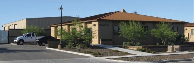
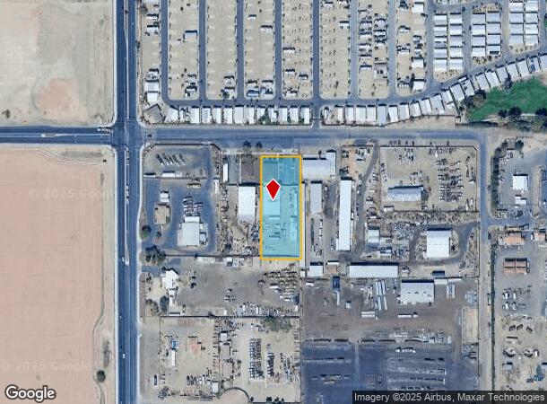
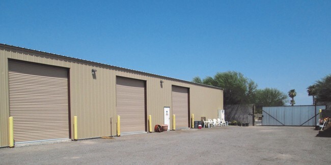
12225 W Peoria Ave
Phoenix-Mesa-Scottsdale, AZ
Hark Drilling Yard Mld
501-45-948
HARK DRILLING YARD MLD MCR 1224-01
Commercialnec
Maricopa
X
Arizona
04013C1680L
2
2025
1.23 AC
2025
Glendale
061043
Phoenix
9,200 SF
DEMOGRAPHICS near 12225 W Peoria Ave
1 Mile
3 Mile
5 Mile
2024 Total Population
3,681
73,099
215,170
2029 Population
3,952
79,190
233,732
Pop Growth 2024-2029
+ 7.36%
+ 8.33%
+ 8.63%
Average Age
35
42
42
2024 Total Households
1,061
27,585
82,173
HH Growth 2024-2029
+ 7.35%
+ 8.57%
+ 8.80%
Median Household Inc
$79,062
$58,567
$65,389
Avg Household Size
3.40
2.60
2.50
2024 Avg HH Vehicles
2.00
2.00
2.00
Median Home Value
$402,163
$245,411
$286,004
Median Year Built
2003
1991
1995
Nearby Places
Map Layers
Map Styles
 Street
 Aerial
- Restaurants
- Banks
- Shops
- Fitness
- Groceries
PUBLIC TRANSPORTATION
AIRPORT
Phoenix Sky Harbor International
DRIVE
WALK
Distance
Phoenix Sky Harbor International
42 min
28.9 mi
Nearby Properties
Address
Land Use
TOTAL SIZE
Lot Size
Zoning
Address
Land Use
TOTAL SIZE
Lot Size
Zoning
138.98 AC
Address
Land Use
TOTAL SIZE
Lot Size
Zoning
71.40 AC
Address
Land Use
TOTAL SIZE
Lot Size
Zoning
35.74 AC
Address
Land Use
TOTAL SIZE
Lot Size
Zoning
303,419 SF
31.47 AC
Address
Land Use
TOTAL SIZE
Lot Size
Zoning
1,010,365 SF
29.94 AC
C2
Address
Land Use
TOTAL SIZE
Lot Size
Zoning
53.02 AC
Address
Land Use
TOTAL SIZE
Lot Size
Zoning
16,341 SF
174.45 AC
R-43
Address
Land Use
TOTAL SIZE
Lot Size
Zoning
294,360 SF
21.69 AC
EI
Address
Land Use
TOTAL SIZE
Lot Size
Zoning
225,457 SF
70.07 AC
PAD
Address
Land Use
TOTAL SIZE
Lot Size
Zoning
20,948 SF
2.39 AC
R-6
Address
Land Use
TOTAL SIZE
Lot Size
Zoning
291,028 SF
20.62 AC
Address
Land Use
TOTAL SIZE
Lot Size
Zoning
327,311 SF
21.14 AC
RM-1
Address
Land Use
TOTAL SIZE
Lot Size
Zoning
113,020 SF
16.37 AC
R-43
Address
Land Use
TOTAL SIZE
Lot Size
Zoning
418,305 SF
24.06 AC
PAD
Address
Land Use
TOTAL SIZE
Lot Size
Zoning
242,740 SF
20.21 AC
M1
Address
Land Use
TOTAL SIZE
Lot Size
Zoning
247,178 SF
33.92 AC
PAD
Address
Land Use
TOTAL SIZE
Lot Size
Zoning
106,356 SF
14.16 AC
PAD
Address
Land Use
TOTAL SIZE
Lot Size
Zoning
93,832 SF
79 AC
AG
Address
Land Use
TOTAL SIZE
Lot Size
Zoning
145,491 SF
37.61 AC
PAD
Address
Land Use
TOTAL SIZE
Lot Size
Zoning
707,380 SF
46.26 AC
I-2
Address
Land Use
TOTAL SIZE
Lot Size
Zoning
67,932 SF
14.90 AC
PAD
Address
Land Use
TOTAL SIZE
Lot Size
Zoning
199,390 SF
24.59 AC
C-C
Address
Land Use
TOTAL SIZE
Lot Size
Zoning
116,323 SF
17.38 AC
R-8
Address
Land Use
TOTAL SIZE
Lot Size
Zoning
270,000 SF
16.26 AC
PAD
Address
Land Use
TOTAL SIZE
Lot Size
Zoning
153,525 SF
14.48 AC
PAD
Address
Land Use
TOTAL SIZE
Lot Size
Zoning
112,957 SF
17.40 AC
PAD
Address
Land Use
TOTAL SIZE
Lot Size
Zoning
123,820 SF
4.53 AC
C-C
Address
Land Use
TOTAL SIZE
Lot Size
Zoning
97,910 SF
26.16 AC
PAD
Address
Land Use
TOTAL SIZE
Lot Size
Zoning
163,595 SF
17.52 AC
PAD
Address
Land Use
TOTAL SIZE
Lot Size
Zoning
The World's #1 Commercial Real Estate Marketplace
Connect with us
© 2025 CoStar Group
The information above has been obtained from sources believed reliable. While we do not doubt its accuracy we have not verified it and make no guarantee, warranty or representation about it. It is your responsibility to independently confirm its accuracy and completeness. Any projections, opinions, assumptions, or estimates used are for example only and do not represent the current or future performance of the property. The value of this transaction to you depends on tax and other factors which should be evaluated by your tax, financial, and legal advisors. You and your advisors should conduct a careful, independent investigation of the property to determine to your satisfaction the suitability of the property for your needs.