Property Record
1223 Highway 51, Madison, MS 39110
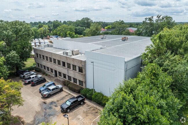

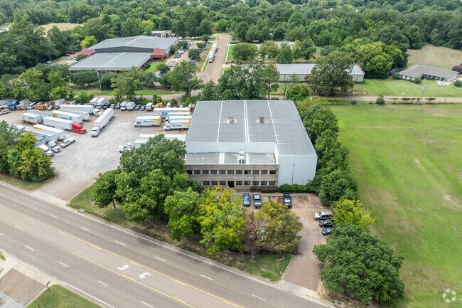
Property Detail
1223 Highway 51
072B-04C-001-02-00
2.971A IN SW1/4 LYING W OF HWY 51
Lightindustrial
Madison
B and X Area of moderate flood hazard, usually the area between the limits of the 100-year and 500-year floods.
Mississippi
2025
3.08 AC
2025
Outlying Madison County
030203
Jackson
22,093 SF
Jackson, MS
NEARBY LISTINGS FOR SALE OR LEASE
DEMOGRAPHICS near 1223 Highway 51
1 mile
3 mile
5 mile
2025 Total Population
5,184
22,461
65,475
2030 Population
5,337
23,243
68,283
Pop Growth 2025-2030
+ 2.95%
+ 3.48%
+ 4.29%
Average Age
40
40
39
2025 Total Households
1,936
8,352
25,595
HH Growth 2025-2030
+ 3.25%
+ 3.71%
+ 4.63%
Median Household Inc
$96,922
$99,922
$87,872
Avg Household Size
2.60
2.60
2.50
2025 Avg HH Vehicles
2.00
2.00
2.00
Median Home Value
$328,611
$352,868
$352,693
Median Year Built
1995
1995
1995
Nearby Places
Map Layers
Map Styles
 Street
 Aerial
Layers
 Traffic
 Biking
Places
Listings with unknown addresses are not visible on the map
- Restaurants
- Banks
- Shops
- Fitness
- Groceries
PUBLIC TRANSPORTATION
AIRPORT
Jackson-Medgar Wiley Evers International
Drive
Walk
Distance
Jackson-Medgar Wiley Evers International
33 min
20.2 mi
Nearby Properties
Address
Land Use
TOTAL SIZE
Lot Size
Zoning
Address
Land Use
TOTAL SIZE
Lot Size
Zoning
78,922 SF
26.14 AC
Address
Land Use
TOTAL SIZE
Lot Size
Zoning
178,482 SF
23.13 AC
Address
Land Use
TOTAL SIZE
Lot Size
Zoning
117,149 SF
10.58 AC
Address
Land Use
TOTAL SIZE
Lot Size
Zoning
79,666 SF
7.92 AC
Address
Land Use
TOTAL SIZE
Lot Size
Zoning
225 SF
12.81 AC
Address
Land Use
TOTAL SIZE
Lot Size
Zoning
84,542 SF
6.29 AC
Address
Land Use
TOTAL SIZE
Lot Size
Zoning
68,017 SF
10.56 AC
Address
Land Use
TOTAL SIZE
Lot Size
Zoning
29,237 SF
49.20 AC
C2
Address
Land Use
TOTAL SIZE
Lot Size
Zoning
112 SF
7 AC
Address
Land Use
TOTAL SIZE
Lot Size
Zoning
148,808 SF
12.80 AC
Address
Land Use
TOTAL SIZE
Lot Size
Zoning
23,474 SF
9.50 AC
Address
Land Use
TOTAL SIZE
Lot Size
Zoning
76,309 SF
7.38 AC
Address
Land Use
TOTAL SIZE
Lot Size
Zoning
122,775 SF
8.40 AC
Address
Land Use
TOTAL SIZE
Lot Size
Zoning
85,526 SF
6.94 AC
Address
Land Use
TOTAL SIZE
Lot Size
Zoning
62,194 SF
3.03 AC
Address
Land Use
TOTAL SIZE
Lot Size
Zoning
110,361 SF
11.35 AC
Address
Land Use
TOTAL SIZE
Lot Size
Zoning
68,984 SF
2.56 AC
Address
Land Use
TOTAL SIZE
Lot Size
Zoning
63,374 SF
7.40 AC
Address
Land Use
TOTAL SIZE
Lot Size
Zoning
4,000 SF
15.29 AC
I1
Address
Land Use
TOTAL SIZE
Lot Size
Zoning
90,847 SF
5.40 AC
C2
Address
Land Use
TOTAL SIZE
Lot Size
Zoning
123,656 SF
6.86 AC
Address
Land Use
TOTAL SIZE
Lot Size
Zoning
64,626 SF
7.07 AC
Address
Land Use
TOTAL SIZE
Lot Size
Zoning
47,511 SF
4.40 AC
Address
Land Use
TOTAL SIZE
Lot Size
Zoning
43,139 SF
5.97 AC
Address
Land Use
TOTAL SIZE
Lot Size
Zoning
41,436 SF
4.37 AC
Address
Land Use
TOTAL SIZE
Lot Size
Zoning
49,404 SF
6.17 AC
Address
Land Use
TOTAL SIZE
Lot Size
Zoning
1,600 SF
11.17 AC
Address
Land Use
TOTAL SIZE
Lot Size
Zoning
185,680 SF
Address
Land Use
TOTAL SIZE
Lot Size
Zoning
31,020 SF
6.40 AC
Address
Land Use
TOTAL SIZE
Lot Size
Zoning
57,587 SF
1.56 AC
The World's #1 Commercial Real Estate Marketplace
Connect with us
© 2026 CoStar Group
The information above has been obtained from sources believed reliable. While we do not doubt its accuracy we have not verified it and make no guarantee, warranty or representation about it. It is your responsibility to independently confirm its accuracy and completeness. Any projections, opinions, assumptions, or estimates used are for example only and do not represent the current or future performance of the property. The value of this transaction to you depends on tax and other factors which should be evaluated by your tax, financial, and legal advisors. You and your advisors should conduct a careful, independent investigation of the property to determine to your satisfaction the suitability of the property for your needs.