Property Record
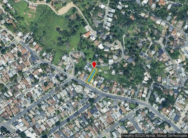
3550 Tacoma Ave, Los Angeles, CA 90065
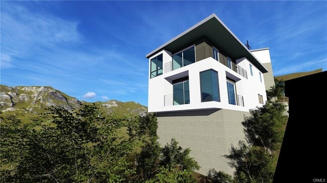
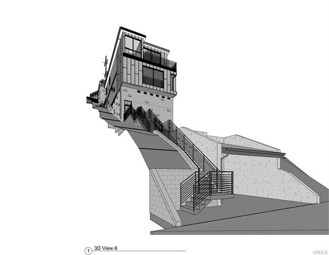
This Property Is For Sale
NEARBY LISTINGS FOR SALE OR LEASE
Property Detail
3550 Tacoma Ave
Los Angeles-Long Beach-Glendale, CA
4085
5454-013-010
TRACT # 4085 LOT 22
Residentialacreage
Los Angeles
X
California
06037C1626F
22
2024
0.15 AC
2025
Glendale
185202
Los Angeles
DEMOGRAPHICS near 3550 Tacoma Ave
1 Mile
3 Mile
5 Mile
2024 Total Population
23,607
259,257
915,445
2029 Population
22,703
249,408
888,703
Pop Growth 2024-2029
(3.83%)
(3.80%)
(2.92%)
Average Age
41
40
40
2024 Total Households
7,970
94,153
353,936
HH Growth 2024-2029
(4.23%)
(4.13%)
(2.93%)
Median Household Inc
$77,010
$81,230
$65,406
Avg Household Size
2.80
2.60
2.40
2024 Avg HH Vehicles
2.00
2.00
1.00
Median Home Value
$899,169
$884,432
$878,559
Median Year Built
1948
1954
1960
Nearby Places
Map Layers
Map Styles
 Street
 Aerial
- Restaurants
- Banks
- Shops
- Fitness
- Groceries
PUBLIC TRANSPORTATION
COMMUTER RAIL
Glendale (Antelope Valley Line - Southern California Regional Rail Authority (Metrolink), Ventura County Line - Southern California Regional Rail Authority (Metrolink))
DRIVE
WALK
Distance
Glendale (Antelope Valley Line - Southern California Regional Rail Authority (Metrolink), Ventura County Line - Southern California Regional Rail Authority (Metrolink))
6 min
3.1 mi
Union Station (91 Line - Southern California Regional Rail Authority (Metrolink), Antelope Valley Line - Southern California Regional Rail Authority (Metrolink), Orange County Line - Southern California Regional Rail Authority (Metrolink), Riverside Line - Southern California Regional Rail Authority (Metrolink), San Bernardino Line - Southern California Regional Rail Authority (Metrolink), Ventura County Line - Southern California Regional Rail Authority (Metrolink))
DRIVE
WALK
Distance
Union Station (91 Line - Southern California Regional Rail Authority (Metrolink), Antelope Valley Line - Southern California Regional Rail Authority (Metrolink), Orange County Line - Southern California Regional Rail Authority (Metrolink), Riverside Line - Southern California Regional Rail Authority (Metrolink), San Bernardino Line - Southern California Regional Rail Authority (Metrolink), Ventura County Line - Southern California Regional Rail Authority (Metrolink))
10 min
3.8 mi
AIRPORT
Bob Hope
DRIVE
WALK
Distance
Bob Hope
22 min
14.7 mi
Los Angeles International
DRIVE
WALK
Distance
Los Angeles International
31 min
18.8 mi
Long Beach (Daugherty Field)
DRIVE
WALK
Distance
Long Beach (Daugherty Field)
37 min
24.3 mi
Freight Ports
Port of Long Beach
DRIVE
WALK
Distance
Port of Long Beach
38 min
27.2 mi
Nearby Properties
Address
Land Use
TOTAL SIZE
Lot Size
Zoning
Address
Land Use
TOTAL SIZE
Lot Size
Zoning
816,046 SF
15.37 AC
LAA1
Address
Land Use
TOTAL SIZE
Lot Size
Zoning
465,722 SF
5.84 AC
LAC4
Address
Land Use
TOTAL SIZE
Lot Size
Zoning
513,825 SF
4.28 AC
LAC2
Address
Land Use
TOTAL SIZE
Lot Size
Zoning
534,225 SF
Address
Land Use
TOTAL SIZE
Lot Size
Zoning
251,317 SF
114.56 AC
LAR1
Address
Land Use
TOTAL SIZE
Lot Size
Zoning
1,059,650 SF
1.07 AC
LAC2
Address
Land Use
TOTAL SIZE
Lot Size
Zoning
349,519 SF
2.16 AC
GLM1*
Address
Land Use
TOTAL SIZE
Lot Size
Zoning
175.69 AC
LAA1
Address
Land Use
TOTAL SIZE
Lot Size
Zoning
328,737 SF
7.92 AC
LAC2
Address
Land Use
TOTAL SIZE
Lot Size
Zoning
642,160 SF
8.26 AC
LAADP
Address
Land Use
TOTAL SIZE
Lot Size
Zoning
368,058 SF
2.65 AC
LAUC (CA)
Address
Land Use
TOTAL SIZE
Lot Size
Zoning
354,299 SF
2.18 AC
LAC2
Address
Land Use
TOTAL SIZE
Lot Size
Zoning
150,608 SF
0.88 AC
LAC2
Address
Land Use
TOTAL SIZE
Lot Size
Zoning
245,031 SF
2.21 AC
GLM2
Address
Land Use
TOTAL SIZE
Lot Size
Zoning
342,600 SF
2.55 AC
LAC4
Address
Land Use
TOTAL SIZE
Lot Size
Zoning
225,923 SF
1.31 AC
LAR5
Address
Land Use
TOTAL SIZE
Lot Size
Zoning
119,455 SF
5.04 AC
LACM
Address
Land Use
TOTAL SIZE
Lot Size
Zoning
53,760 SF
4.60 AC
LAM1
Address
Land Use
TOTAL SIZE
Lot Size
Zoning
252,559 SF
2.87 AC
LAC2
Address
Land Use
TOTAL SIZE
Lot Size
Zoning
195,526 SF
2.81 AC
LAADP
Address
Land Use
TOTAL SIZE
Lot Size
Zoning
358,305 SF
2.69 AC
LAC2
Address
Land Use
TOTAL SIZE
Lot Size
Zoning
222,940 SF
2.48 AC
LAC2
Address
Land Use
TOTAL SIZE
Lot Size
Zoning
329,063 SF
0.23 AC
LAC2
Address
Land Use
TOTAL SIZE
Lot Size
Zoning
212,165 SF
1.51 AC
LAC2
Address
Land Use
TOTAL SIZE
Lot Size
Zoning
314,760 SF
3.77 AC
GLC3
Address
Land Use
TOTAL SIZE
Lot Size
Zoning
172,072 SF
1.82 AC
LAC2
Address
Land Use
TOTAL SIZE
Lot Size
Zoning
75,589 SF
0.98 AC
LAC2
Address
Land Use
TOTAL SIZE
Lot Size
Zoning
1,086,660 SF
26.15 AC
LAM3
Address
Land Use
TOTAL SIZE
Lot Size
Zoning
116,109 SF
0.92 AC
LACM
Address
Land Use
TOTAL SIZE
Lot Size
Zoning
22,584 SF
62.57 AC
LAA1
The World's #1 Commercial Real Estate Marketplace
Connect with us
© 2025 CoStar Group
The information above has been obtained from sources believed reliable. While we do not doubt its accuracy we have not verified it and make no guarantee, warranty or representation about it. It is your responsibility to independently confirm its accuracy and completeness. Any projections, opinions, assumptions, or estimates used are for example only and do not represent the current or future performance of the property. The value of this transaction to you depends on tax and other factors which should be evaluated by your tax, financial, and legal advisors. You and your advisors should conduct a careful, independent investigation of the property to determine to your satisfaction the suitability of the property for your needs.