Property Record
1223 N Sylmar Ave, Fresno, CA 93727

This Property Is For Sale
NEARBY LISTINGS FOR SALE OR LEASE
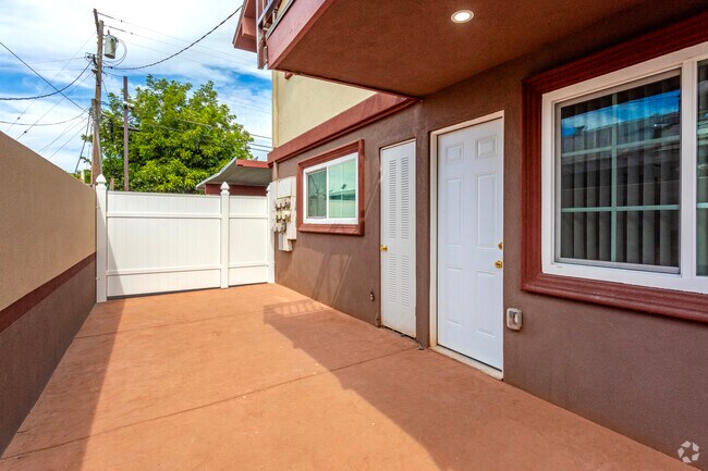
Property Detail
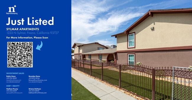
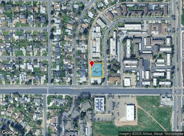
1223 N Sylmar Ave
Fresno, CA
Willow Estates
455-162-18
LOTS 114 & 115 TRACT NO.1789 WILLOW ESTATES
Apartment
Fresno
X
California
06019C1590H
115
2025
0.45 AC
2025
Roosevelt
002906
Fresno
11,660 SF
DEMOGRAPHICS near 1223 N Sylmar Ave
1 Mile
3 Mile
5 Mile
2024 Total Population
16,491
150,845
357,994
2029 Population
16,708
154,146
365,897
Pop Growth 2024-2029
+ 1.32%
+ 2.19%
+ 2.21%
Average Age
33
34
35
2024 Total Households
4,650
44,566
112,033
HH Growth 2024-2029
+ 1.27%
+ 2.22%
+ 2.24%
Median Household Inc
$46,944
$46,707
$53,129
Avg Household Size
3.40
3.30
3.10
2024 Avg HH Vehicles
2.00
2.00
2.00
Median Home Value
$249,591
$257,846
$288,897
Median Year Built
1968
1971
1972
Nearby Places
Map Layers
Map Styles
 Street
 Aerial
- Restaurants
- Banks
- Shops
- Fitness
- Groceries
PUBLIC TRANSPORTATION
COMMUTER RAIL
Fresno (San Joaquins - Amtrak)
DRIVE
WALK
Distance
Fresno (San Joaquins - Amtrak)
8 min
4.9 mi
AIRPORT
Fresno Yosemite International
DRIVE
WALK
Distance
Fresno Yosemite International
4 min
1.5 mi
Freight Ports
Port of Stockton
DRIVE
WALK
Distance
Port of Stockton
157 min
131.9 mi
Nearby Properties
Address
Land Use
TOTAL SIZE
Lot Size
Zoning
Address
Land Use
TOTAL SIZE
Lot Size
Zoning
1,081,456 SF
113.56 AC
M1
Address
Land Use
TOTAL SIZE
Lot Size
Zoning
794,471 SF
73.71 AC
Address
Land Use
TOTAL SIZE
Lot Size
Zoning
74,499 SF
17.48 AC
M3
Address
Land Use
TOTAL SIZE
Lot Size
Zoning
2,008 SF
20.14 AC
M1
Address
Land Use
TOTAL SIZE
Lot Size
Zoning
202,149 SF
27.56 AC
SPLIT
Address
Land Use
TOTAL SIZE
Lot Size
Zoning
385,529 SF
29.36 AC
R2
Address
Land Use
TOTAL SIZE
Lot Size
Zoning
372,862 SF
42.43 AC
R1
Address
Land Use
TOTAL SIZE
Lot Size
Zoning
116,349 SF
16.56 AC
CP
Address
Land Use
TOTAL SIZE
Lot Size
Zoning
60,227 SF
4.72 AC
M1
Address
Land Use
TOTAL SIZE
Lot Size
Zoning
194,109 SF
19.42 AC
C3
Address
Land Use
TOTAL SIZE
Lot Size
Zoning
175,310 SF
19.22 AC
CMX
Address
Land Use
TOTAL SIZE
Lot Size
Zoning
94,584 SF
10.93 AC
M1
Address
Land Use
TOTAL SIZE
Lot Size
Zoning
93,172 SF
4.97 AC
Address
Land Use
TOTAL SIZE
Lot Size
Zoning
249,126 SF
17.33 AC
SPLIT
Address
Land Use
TOTAL SIZE
Lot Size
Zoning
250,412 SF
16.09 AC
RM3
Address
Land Use
TOTAL SIZE
Lot Size
Zoning
319,790 SF
41.15 AC
R1
Address
Land Use
TOTAL SIZE
Lot Size
Zoning
190,006 SF
19.35 AC
RM1
Address
Land Use
TOTAL SIZE
Lot Size
Zoning
102,765 SF
8.90 AC
M1
Address
Land Use
TOTAL SIZE
Lot Size
Zoning
151,980 SF
4.94 AC
CM
Address
Land Use
TOTAL SIZE
Lot Size
Zoning
212,113 SF
13.21 AC
R3
Address
Land Use
TOTAL SIZE
Lot Size
Zoning
138,502 SF
3.46 AC
C2
Address
Land Use
TOTAL SIZE
Lot Size
Zoning
119,914 SF
4.50 AC
CMX
Address
Land Use
TOTAL SIZE
Lot Size
Zoning
141,577 SF
12.76 AC
IL
Address
Land Use
TOTAL SIZE
Lot Size
Zoning
226,937 SF
20.15 AC
SPLIT
Address
Land Use
TOTAL SIZE
Lot Size
Zoning
171,783 SF
8.30 AC
M1
Address
Land Use
TOTAL SIZE
Lot Size
Zoning
226,937 SF
11.52 AC
Address
Land Use
TOTAL SIZE
Lot Size
Zoning
26,978 SF
2.25 AC
Address
Land Use
TOTAL SIZE
Lot Size
Zoning
95,932 SF
10.98 AC
C3
Address
Land Use
TOTAL SIZE
Lot Size
Zoning
59,073 SF
2.66 AC
CM
Address
Land Use
TOTAL SIZE
Lot Size
Zoning
106,563 SF
0.01 AC
C2
The World's #1 Commercial Real Estate Marketplace
Connect with us
© 2026 CoStar Group
The information above has been obtained from sources believed reliable. While we do not doubt its accuracy we have not verified it and make no guarantee, warranty or representation about it. It is your responsibility to independently confirm its accuracy and completeness. Any projections, opinions, assumptions, or estimates used are for example only and do not represent the current or future performance of the property. The value of this transaction to you depends on tax and other factors which should be evaluated by your tax, financial, and legal advisors. You and your advisors should conduct a careful, independent investigation of the property to determine to your satisfaction the suitability of the property for your needs.