Property Record
1226 Us Highway 10 W, Livingston, MT 59047
Current Lease Availabilities
NEARBY LISTINGS FOR SALE OR LEASE
Property Detail
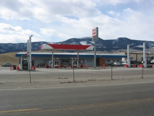
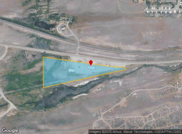
1226 Us Highway 10 W
Truckstopfuelanddiner
S22, T02 S, R09 E, C.O.S. 2896, PARCEL 1-2
X
Park
30067C0590C
Montana
2025
10.40 AC
2025
Bozeman/Yellowstone Country
000400
Other Market Areas
4,555 SF
49-0802-22-1-03-05-0000
DEMOGRAPHICS near 1226 Us Highway 10 W
1 Mile
3 Mile
5 Mile
2024 Total Population
1,140
11,250
12,317
2029 Population
1,236
12,284
13,445
Pop Growth 2024-2029
+ 8.42%
+ 9.19%
+ 9.16%
Average Age
43
44
44
2024 Total Households
470
5,279
5,736
HH Growth 2024-2029
+ 8.30%
+ 9.30%
+ 9.26%
Median Household Inc
$99,801
$58,309
$58,694
Avg Household Size
2.30
2.10
2.10
2024 Avg HH Vehicles
3.00
2.00
2.00
Median Home Value
$522,152
$356,387
$355,970
Median Year Built
1997
1971
1973
Nearby Places
- Restaurants
- Banks
- Shops
- Fitness
- Groceries
PUBLIC TRANSPORTATION
AIRPORT
Bozeman Yellowstone International
DRIVE
WALK
Distance
Bozeman Yellowstone International
36 min
33.1 mi
Freight Ports
Port of Everett
DRIVE
WALK
Distance
Port of Everett
767 min
723.5 mi
Nearby Properties
Address
Land Use
TOTAL SIZE
Lot Size
Zoning
Address
Land Use
TOTAL SIZE
Lot Size
Zoning
19,840 SF
20.09 AC
2
Address
Land Use
TOTAL SIZE
Lot Size
Zoning
51,813 SF
2.46 AC
2
Address
Land Use
TOTAL SIZE
Lot Size
Zoning
58,289 SF
1.94 AC
Address
Land Use
TOTAL SIZE
Lot Size
Zoning
44,957 SF
4.30 AC
2
Address
Land Use
TOTAL SIZE
Lot Size
Zoning
42,541 SF
4.56 AC
COMM
Address
Land Use
TOTAL SIZE
Lot Size
Zoning
14,030 SF
1.41 AC
Address
Land Use
TOTAL SIZE
Lot Size
Zoning
40,836 SF
4.16 AC
2
Address
Land Use
TOTAL SIZE
Lot Size
Zoning
8,229 SF
0.42 AC
2
Address
Land Use
TOTAL SIZE
Lot Size
Zoning
19,712 SF
6.54 AC
Address
Land Use
TOTAL SIZE
Lot Size
Zoning
36,565 SF
0.56 AC
2
Address
Land Use
TOTAL SIZE
Lot Size
Zoning
46,793 SF
0.64 AC
2
Address
Land Use
TOTAL SIZE
Lot Size
Zoning
40,683 SF
2.02 AC
2
Address
Land Use
TOTAL SIZE
Lot Size
Zoning
14,040 SF
0.88 AC
2
Address
Land Use
TOTAL SIZE
Lot Size
Zoning
77,208 SF
1.85 AC
2
Address
Land Use
TOTAL SIZE
Lot Size
Zoning
23,020 SF
1.13 AC
Address
Land Use
TOTAL SIZE
Lot Size
Zoning
46,120 SF
6.75 AC
2
Address
Land Use
TOTAL SIZE
Lot Size
Zoning
3,850 SF
2.74 AC
Address
Land Use
TOTAL SIZE
Lot Size
Zoning
24,231 SF
0.16 AC
2
Address
Land Use
TOTAL SIZE
Lot Size
Zoning
2,400 SF
4.06 AC
Address
Land Use
TOTAL SIZE
Lot Size
Zoning
10,687 SF
0.50 AC
2
Address
Land Use
TOTAL SIZE
Lot Size
Zoning
19,053 SF
1.17 AC
2
Address
Land Use
TOTAL SIZE
Lot Size
Zoning
38,897 SF
2.73 AC
2
Address
Land Use
TOTAL SIZE
Lot Size
Zoning
3,465 SF
2.82 AC
2
Address
Land Use
TOTAL SIZE
Lot Size
Zoning
850 SF
77.39 AC
Address
Land Use
TOTAL SIZE
Lot Size
Zoning
23,385 SF
0.27 AC
2
Address
Land Use
TOTAL SIZE
Lot Size
Zoning
16,510 SF
0.47 AC
2
Address
Land Use
TOTAL SIZE
Lot Size
Zoning
24,680 SF
0.78 AC
2
Address
Land Use
TOTAL SIZE
Lot Size
Zoning
17,221 SF
1.32 AC
Address
Land Use
TOTAL SIZE
Lot Size
Zoning
28,084 SF
1.94 AC
2
Address
Land Use
TOTAL SIZE
Lot Size
Zoning
31,454 SF
0.24 AC
2
The World's #1 Commercial Real Estate Marketplace
Connect with us
© 2025 CoStar Group
The information above has been obtained from sources believed reliable. While we do not doubt its accuracy we have not verified it and make no guarantee, warranty or representation about it. It is your responsibility to independently confirm its accuracy and completeness. Any projections, opinions, assumptions, or estimates used are for example only and do not represent the current or future performance of the property. The value of this transaction to you depends on tax and other factors which should be evaluated by your tax, financial, and legal advisors. You and your advisors should conduct a careful, independent investigation of the property to determine to your satisfaction the suitability of the property for your needs.