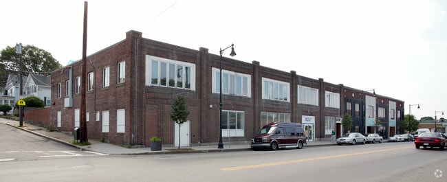
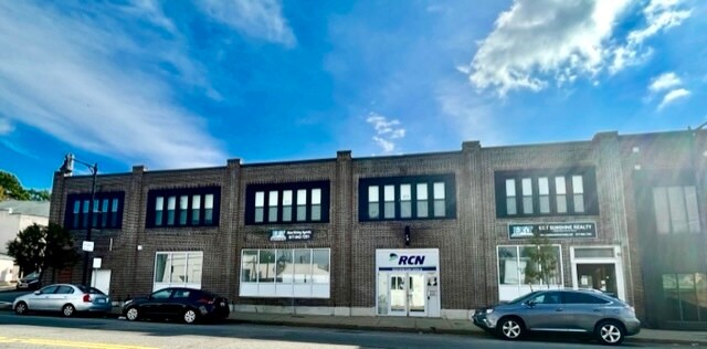
Property Record
1220 Hyde Park Ave, Hyde Park, MA 02136
Current Lease Availabilities
NEARBY LISTINGS FOR SALE OR LEASE
Property Detail
1220 Hyde Park Ave
Officebuilding
Suffolk
X
Massachusetts
25021C0063F
0.28 AC
2025
South Suffolk County
2025
Boston
140300
Boston-Cambridge-Newton, MA-NH
11,760 SF
HYDE-000000-000018-009081
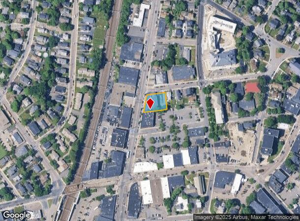
DEMOGRAPHICS near 1220 Hyde Park Ave
1 Mile
3 Mile
5 Mile
2024 Total Population
19,614
153,805
366,742
2029 Population
18,293
146,980
350,886
Pop Growth 2024-2029
(6.73%)
(4.44%)
(4.32%)
Average Age
42
41
40
2024 Total Households
6,975
57,212
136,876
HH Growth 2024-2029
(7.51%)
(4.98%)
(4.82%)
Median Household Inc
$88,770
$92,564
$89,683
Avg Household Size
2.70
2.60
2.50
2024 Avg HH Vehicles
2.00
1.00
1.00
Median Home Value
$493,376
$630,682
$693,907
Median Year Built
1949
1949
1949
Nearby Places
Map Layers
Map Styles
 Street
 Aerial
- Restaurants
- Banks
- Shops
- Fitness
- Groceries
PUBLIC TRANSPORTATION
TRANSIT/SUBWAY
Hyde Park (Franklin Line - Massachusetts Bay Transportation Authority Commuter Rail (Purple Line), Providence/Stoughton Line - Massachusetts Bay Transportation Authority Commuter Rail (Purple Line))
DRIVE
WALK
Distance
Hyde Park (Franklin Line - Massachusetts Bay Transportation Authority Commuter Rail (Purple Line), Providence/Stoughton Line - Massachusetts Bay Transportation Authority Commuter Rail (Purple Line))
1 min
4 min
0.2 mi
Fairmount (Fairmount Line - Massachusetts Bay Transportation Authority Commuter Rail (Purple Line))
DRIVE
WALK
Distance
Fairmount (Fairmount Line - Massachusetts Bay Transportation Authority Commuter Rail (Purple Line))
1 min
9 min
0.4 mi
COMMUTER RAIL
Hyde Park (Franklin Line - Massachusetts Bay Transportation Authority Commuter Rail (Purple Line), Providence/Stoughton Line - Massachusetts Bay Transportation Authority Commuter Rail (Purple Line))
DRIVE
WALK
Distance
Hyde Park (Franklin Line - Massachusetts Bay Transportation Authority Commuter Rail (Purple Line), Providence/Stoughton Line - Massachusetts Bay Transportation Authority Commuter Rail (Purple Line))
1 min
4 min
0.2 mi
Fairmount (Fairmount Line - Massachusetts Bay Transportation Authority Commuter Rail (Purple Line))
DRIVE
WALK
Distance
Fairmount (Fairmount Line - Massachusetts Bay Transportation Authority Commuter Rail (Purple Line))
1 min
8 min
0.4 mi
AIRPORT
General Edward Lawrence Logan International
DRIVE
WALK
Distance
General Edward Lawrence Logan International
22 min
11.3 mi
Freight Ports
Port of Boston
DRIVE
WALK
Distance
Port of Boston
20 min
9.9 mi
Nearby Properties
Address
Land Use
TOTAL SIZE
Lot Size
Zoning
Address
Land Use
TOTAL SIZE
Lot Size
Zoning
45,000 SF
14.30 AC
E
Address
Land Use
TOTAL SIZE
Lot Size
Zoning
355,941 SF
4.60 AC
A
Address
Land Use
TOTAL SIZE
Lot Size
Zoning
179.13 AC
E
Address
Land Use
TOTAL SIZE
Lot Size
Zoning
225,042 SF
63.16 AC
RA
Address
Land Use
TOTAL SIZE
Lot Size
Zoning
1,660.52 AC
RA
Address
Land Use
TOTAL SIZE
Lot Size
Zoning
1,940 SF
58.17 AC
E
Address
Land Use
TOTAL SIZE
Lot Size
Zoning
240.18 AC
E
Address
Land Use
TOTAL SIZE
Lot Size
Zoning
34.93 AC
LM
Address
Land Use
TOTAL SIZE
Lot Size
Zoning
270,991 SF
33.25 AC
RA
Address
Land Use
TOTAL SIZE
Lot Size
Zoning
21,830 SF
158.48 AC
E
Address
Land Use
TOTAL SIZE
Lot Size
Zoning
26,569 SF
45.93 AC
RC
Address
Land Use
TOTAL SIZE
Lot Size
Zoning
8.18 AC
B
Address
Land Use
TOTAL SIZE
Lot Size
Zoning
22.95 AC
E
Address
Land Use
TOTAL SIZE
Lot Size
Zoning
217,302 SF
13.47 AC
RA
Address
Land Use
TOTAL SIZE
Lot Size
Zoning
83,891 SF
3.47 AC
RA
Address
Land Use
TOTAL SIZE
Lot Size
Zoning
475,102 SF
36.81 AC
A
Address
Land Use
TOTAL SIZE
Lot Size
Zoning
45.72 AC
LM
Address
Land Use
TOTAL SIZE
Lot Size
Zoning
108,500 SF
2.38 AC
E
Address
Land Use
TOTAL SIZE
Lot Size
Zoning
156,310 SF
9.40 AC
E
Address
Land Use
TOTAL SIZE
Lot Size
Zoning
20,580 SF
20.51 AC
E
Address
Land Use
TOTAL SIZE
Lot Size
Zoning
130,867 SF
15.29 AC
RA
Address
Land Use
TOTAL SIZE
Lot Size
Zoning
138,986 SF
10.07 AC
E
Address
Land Use
TOTAL SIZE
Lot Size
Zoning
61,044 SF
5.60 AC
Address
Land Use
TOTAL SIZE
Lot Size
Zoning
296,340 SF
4.58 AC
A
Address
Land Use
TOTAL SIZE
Lot Size
Zoning
99,497 SF
4.12 AC
E
Address
Land Use
TOTAL SIZE
Lot Size
Zoning
11.39 AC
B
Address
Land Use
TOTAL SIZE
Lot Size
Zoning
105,000 SF
5.79 AC
E
Address
Land Use
TOTAL SIZE
Lot Size
Zoning
179,098 SF
8.78 AC
RC
Address
Land Use
TOTAL SIZE
Lot Size
Zoning
213,580 SF
28.61 AC
E
Address
Land Use
TOTAL SIZE
Lot Size
Zoning
205.75 AC
The World's #1 Commercial Real Estate Marketplace
Connect with us
© 2025 CoStar Group
The information above has been obtained from sources believed reliable. While we do not doubt its accuracy we have not verified it and make no guarantee, warranty or representation about it. It is your responsibility to independently confirm its accuracy and completeness. Any projections, opinions, assumptions, or estimates used are for example only and do not represent the current or future performance of the property. The value of this transaction to you depends on tax and other factors which should be evaluated by your tax, financial, and legal advisors. You and your advisors should conduct a careful, independent investigation of the property to determine to your satisfaction the suitability of the property for your needs.