Property Record
1909 Unknown, Satellite Beach, FL 32937

NEARBY LISTINGS FOR SALE OR LEASE
Property Detail
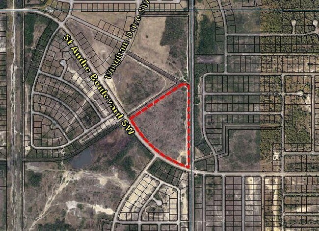
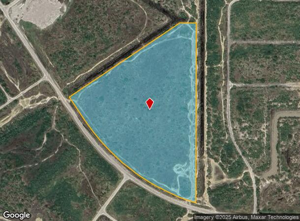
1909 Unknown
Palm Bay-Melbourne-Titusville, FL
Port Malabar Unit 51
29-36-34-KT-0000P.0-0000.00
PORT MALABAR UNIT 51 TRACT P EXC E 10 FT
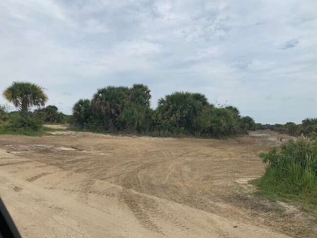
Commercialacreage
Brevard
AE
Florida
12009C0665G
15.57 AC
2024
Brevard County
2025
Orlando
071348
DEMOGRAPHICS near 1909 Unknown
1 Mile
3 Mile
5 Mile
2024 Total Population
92
8,453
38,047
2029 Population
103
9,550
42,348
Pop Growth 2024-2029
+ 11.96%
+ 12.98%
+ 11.30%
Average Age
39
39
40
2024 Total Households
31
2,796
13,351
HH Growth 2024-2029
+ 9.68%
+ 12.59%
+ 11.02%
Median Household Inc
$58,333
$62,817
$62,490
Avg Household Size
3.00
2.90
2.80
2024 Avg HH Vehicles
2.00
2.00
2.00
Median Home Value
$195,832
$233,707
$224,038
Median Year Built
1999
2006
2002
Nearby Places
- Restaurants
- Banks
- Shops
- Fitness
- Groceries
PUBLIC TRANSPORTATION
AIRPORT
Melbourne Orlando International
DRIVE
WALK
Distance
Melbourne Orlando International
41 min
18.2 mi
Freight Ports
Port Canaveral
DRIVE
WALK
Distance
Port Canaveral
73 min
51.7 mi
SALE & LEASE HISTORY
LISTING DATE
SALE/LEASE

Nov 07, 2016
For Sale
Aug 06, 2020
For Sale
Nearby Properties
Address
Land Use
TOTAL SIZE
Lot Size
Zoning
Address
Land Use
TOTAL SIZE
Lot Size
Zoning
107.80 AC
GU
Address
Land Use
TOTAL SIZE
Lot Size
Zoning
468,949 SF
123.35 AC
IU
Address
Land Use
TOTAL SIZE
Lot Size
Zoning
63,962 SF
516.20 AC
LI
Address
Land Use
TOTAL SIZE
Lot Size
Zoning
265.24 AC
GU
Address
Land Use
TOTAL SIZE
Lot Size
Zoning
44,744 SF
478.33 AC
GU
Address
Land Use
TOTAL SIZE
Lot Size
Zoning
43.55 AC
GU
Address
Land Use
TOTAL SIZE
Lot Size
Zoning
21 AC
GU
Address
Land Use
TOTAL SIZE
Lot Size
Zoning
5,926 SF
1.24 AC
GU
Address
Land Use
TOTAL SIZE
Lot Size
Zoning
654.20 AC
GU
Address
Land Use
TOTAL SIZE
Lot Size
Zoning
10,877 SF
595.64 AC
GU
Address
Land Use
TOTAL SIZE
Lot Size
Zoning
7,590 SF
590.20 AC
AU
Address
Land Use
TOTAL SIZE
Lot Size
Zoning
6.32 AC
PUD
Address
Land Use
TOTAL SIZE
Lot Size
Zoning
6,080 SF
9.07 AC
RR
Address
Land Use
TOTAL SIZE
Lot Size
Zoning
11,888 SF
620.61 AC
GU
Address
Land Use
TOTAL SIZE
Lot Size
Zoning
15.62 AC
Address
Land Use
TOTAL SIZE
Lot Size
Zoning
1,800 SF
518.78 AC
GU
Address
Land Use
TOTAL SIZE
Lot Size
Zoning
3,120 SF
371.60 AC
Address
Land Use
TOTAL SIZE
Lot Size
Zoning
13.71 AC
RS2
Address
Land Use
TOTAL SIZE
Lot Size
Zoning
825 SF
7.39 AC
IU
Address
Land Use
TOTAL SIZE
Lot Size
Zoning
12.64 AC
RS2
Address
Land Use
TOTAL SIZE
Lot Size
Zoning
41.85 AC
IU
Address
Land Use
TOTAL SIZE
Lot Size
Zoning
3,220 SF
0.48 AC
SRE
Address
Land Use
TOTAL SIZE
Lot Size
Zoning
62.49 AC
IU
Address
Land Use
TOTAL SIZE
Lot Size
Zoning
4,470 SF
278.20 AC
Address
Land Use
TOTAL SIZE
Lot Size
Zoning
7.70 AC
NC
Address
Land Use
TOTAL SIZE
Lot Size
Zoning
2,400 SF
0.24 AC
SRE
Address
Land Use
TOTAL SIZE
Lot Size
Zoning
11.06 AC
RS2
Address
Land Use
TOTAL SIZE
Lot Size
Zoning
1.71 AC
GU
Address
Land Use
TOTAL SIZE
Lot Size
Zoning
39.15 AC
GU
Address
Land Use
TOTAL SIZE
Lot Size
Zoning
1.50 AC
GU
The World's #1 Commercial Real Estate Marketplace
Connect with us
© 2025 CoStar Group
The information above has been obtained from sources believed reliable. While we do not doubt its accuracy we have not verified it and make no guarantee, warranty or representation about it. It is your responsibility to independently confirm its accuracy and completeness. Any projections, opinions, assumptions, or estimates used are for example only and do not represent the current or future performance of the property. The value of this transaction to you depends on tax and other factors which should be evaluated by your tax, financial, and legal advisors. You and your advisors should conduct a careful, independent investigation of the property to determine to your satisfaction the suitability of the property for your needs.