Property Record
12243 Highway 67, Lakeside, CA 92040
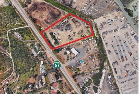

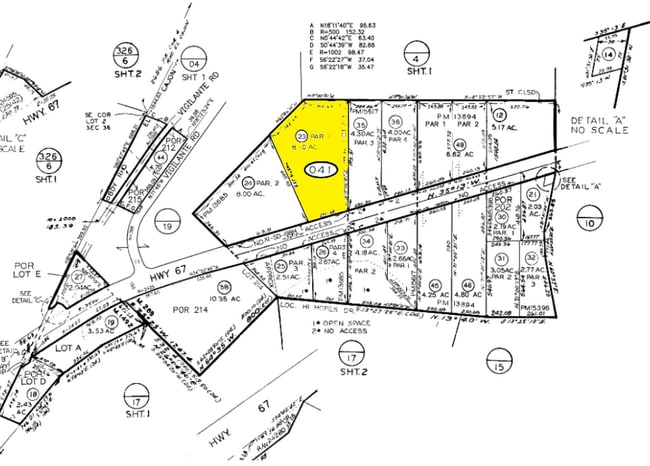
Property Detail
12243 Highway 67
375-041-23
PAR 1 (EX HWY) TR PM13685
Industrialacreage
San Diego
M58
California
AE The base floodplain where base flood elevations are provided. AE Zones are now used on new format FIRMs instead of A1-A30 Zones.
8.10 AC
2024
Outlying SD County S
2025
San Diego
016901
San Diego-Chula Vista-Carlsbad, CA
2,781 SF
NEARBY LISTINGS FOR SALE OR LEASE
DEMOGRAPHICS near 12243 Highway 67
1 mile
3 mile
5 mile
2025 Total Population
704
13,874
75,811
2030 Population
699
13,897
75,671
Pop Growth 2025-2030
(0.71%)
+ 0.17%
(0.18%)
Average Age
43
40
40
2025 Total Households
234
4,766
26,019
HH Growth 2025-2030
(1.28%)
+ 0.06%
(0.32%)
Median Household Inc
$177,272
$105,896
$110,833
Avg Household Size
2.90
2.90
2.80
2025 Avg HH Vehicles
3.00
2.00
2.00
Median Home Value
$930,179
$771,739
$718,965
Median Year Built
1977
1978
1978
Nearby Places
Map Layers
Map Styles
 Street
 Aerial
Layers
 Traffic
 Biking
Places
Listings with unknown addresses are not visible on the map
- Restaurants
- Banks
- Shops
- Fitness
- Groceries
PUBLIC TRANSPORTATION
AIRPORT
San Diego International
Drive
Walk
Distance
San Diego International
33 min
25.2 mi
Freight Ports
Port of San Diego
Drive
Walk
Distance
Port of San Diego
32 min
24.1 mi
SALE & LEASE HISTORY
LISTING DATE
SALE/LEASE

Mar 26, 2018
For Lease
Jun 23, 2022
For Sale
Jun 21, 2022
For Sale
Jun 08, 2020
For Lease
Jan 30, 2018
For Sale
Dec 03, 2020
For Sale
Nearby Properties
Address
Land Use
TOTAL SIZE
Lot Size
Zoning
Address
Land Use
TOTAL SIZE
Lot Size
Zoning
5.77 AC
RU
Address
Land Use
TOTAL SIZE
Lot Size
Zoning
79,662 SF
8.21 AC
S88
Address
Land Use
TOTAL SIZE
Lot Size
Zoning
78,577 SF
14.03 AC
M54
Address
Land Use
TOTAL SIZE
Lot Size
Zoning
103.57 AC
M58
Address
Land Use
TOTAL SIZE
Lot Size
Zoning
80.56 AC
S88
Address
Land Use
TOTAL SIZE
Lot Size
Zoning
119.25 AC
A70
Address
Land Use
TOTAL SIZE
Lot Size
Zoning
41,310 SF
3.51 AC
M54
Address
Land Use
TOTAL SIZE
Lot Size
Zoning
63,746 SF
5.20 AC
S88
Address
Land Use
TOTAL SIZE
Lot Size
Zoning
64,572 SF
2.32 AC
RU
Address
Land Use
TOTAL SIZE
Lot Size
Zoning
44,144 SF
2.39 AC
RU
Address
Land Use
TOTAL SIZE
Lot Size
Zoning
4.80 AC
RU
Address
Land Use
TOTAL SIZE
Lot Size
Zoning
9,200 SF
4.30 AC
M58
Address
Land Use
TOTAL SIZE
Lot Size
Zoning
1,624 SF
4 AC
M58
Address
Land Use
TOTAL SIZE
Lot Size
Zoning
20,154 SF
0.90 AC
RU
Address
Land Use
TOTAL SIZE
Lot Size
Zoning
5.35 AC
M58
Address
Land Use
TOTAL SIZE
Lot Size
Zoning
34,000 SF
67.94 AC
A70
Address
Land Use
TOTAL SIZE
Lot Size
Zoning
8 AC
M58
Address
Land Use
TOTAL SIZE
Lot Size
Zoning
10,000 SF
8.44 AC
M58
Address
Land Use
TOTAL SIZE
Lot Size
Zoning
13,264 SF
3.01 AC
S88
Address
Land Use
TOTAL SIZE
Lot Size
Zoning
17.70 AC
M58
Address
Land Use
TOTAL SIZE
Lot Size
Zoning
46,296 SF
2.21 AC
RU
Address
Land Use
TOTAL SIZE
Lot Size
Zoning
36,875 SF
2.90 AC
S88
Address
Land Use
TOTAL SIZE
Lot Size
Zoning
41,547 SF
2.13 AC
RR
Address
Land Use
TOTAL SIZE
Lot Size
Zoning
49,488 SF
4.20 AC
C36
Address
Land Use
TOTAL SIZE
Lot Size
Zoning
18,788 SF
1.95 AC
S88
Address
Land Use
TOTAL SIZE
Lot Size
Zoning
56,704 SF
2.50 AC
RU
Address
Land Use
TOTAL SIZE
Lot Size
Zoning
40.43 AC
M58
Address
Land Use
TOTAL SIZE
Lot Size
Zoning
40 AC
M58
Address
Land Use
TOTAL SIZE
Lot Size
Zoning
28,132 SF
1.22 AC
RU
The World's #1 Commercial Real Estate Marketplace
Connect with us
© 2026 CoStar Group
The information above has been obtained from sources believed reliable. While we do not doubt its accuracy we have not verified it and make no guarantee, warranty or representation about it. It is your responsibility to independently confirm its accuracy and completeness. Any projections, opinions, assumptions, or estimates used are for example only and do not represent the current or future performance of the property. The value of this transaction to you depends on tax and other factors which should be evaluated by your tax, financial, and legal advisors. You and your advisors should conduct a careful, independent investigation of the property to determine to your satisfaction the suitability of the property for your needs.