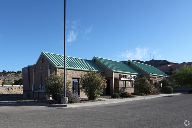
Property Record
1225 E Cliff Dr, El Paso, TX 79902

Current Lease Availabilities
Property Detail
1225 E Cliff Dr
E560-999-0010-0300
1 ELKRIDGE MEDICAL PLAZA NLY PT OF 1 (21.05 ON NLY- 340.14 ON ELY- IRREG ON SLY-303.60 ON WLY) (43581.34 SQ FT)
Commercialnec
EL PASO
AO
Texas
2024
1 AC
2025
Central
002201
El Paso
7,300 SF
El Paso, TX
NEARBY LISTINGS FOR SALE OR LEASE
DEMOGRAPHICS near 1225 E Cliff Dr
1 mile
3 mile
5 mile
2025 Total Population
12,854
66,695
139,635
2030 Population
13,121
67,859
141,635
Pop Growth 2025-2030
+ 2.08%
+ 1.75%
+ 1.43%
Average Age
41
40
39
2025 Total Households
5,543
27,753
56,048
HH Growth 2025-2030
+ 2.38%
+ 1.97%
+ 1.45%
Median Household Inc
$37,860
$35,465
$38,767
Avg Household Size
2.10
2.20
2.40
2025 Avg HH Vehicles
1.00
1.00
2.00
Median Home Value
$288,470
$178,159
$171,383
Median Year Built
1952
1955
1964
Nearby Places
Map Layers
Map Styles
 Street
 Aerial
Transit
 Traffic
 Biking
Places
Listings with unknown addresses are not visible on the map
- Restaurants
- Banks
- Shops
- Fitness
- Groceries
PUBLIC TRANSPORTATION
AIRPORT
El Paso International
Drive
Walk
Distance
El Paso International
25 min
13.1 mi
Nearby Properties
Address
Land Use
TOTAL SIZE
Lot Size
Zoning
Address
Land Use
TOTAL SIZE
Lot Size
Zoning
1,387,028 SF
65.27 AC
R4
Address
Land Use
TOTAL SIZE
Lot Size
Zoning
558,800 SF
1.55 AC
C5
Address
Land Use
TOTAL SIZE
Lot Size
Zoning
318,665 SF
1.43 AC
C5
Address
Land Use
TOTAL SIZE
Lot Size
Zoning
859,302 SF
21.17 AC
C2
Address
Land Use
TOTAL SIZE
Lot Size
Zoning
324,056 SF
1.49 AC
C4
Address
Land Use
TOTAL SIZE
Lot Size
Zoning
1 SF
5.75 AC
C5S
Address
Land Use
TOTAL SIZE
Lot Size
Zoning
347,241 SF
Address
Land Use
TOTAL SIZE
Lot Size
Zoning
89,935 SF
7.01 AC
PMD
Address
Land Use
TOTAL SIZE
Lot Size
Zoning
169,031 SF
1.22 AC
SP
Address
Land Use
TOTAL SIZE
Lot Size
Zoning
313,532 SF
5.73 AC
C1S
Address
Land Use
TOTAL SIZE
Lot Size
Zoning
289,146 SF
11.87 AC
C1S
Address
Land Use
TOTAL SIZE
Lot Size
Zoning
1 SF
45.46 AC
M1
Address
Land Use
TOTAL SIZE
Lot Size
Zoning
164,712 SF
4.68 AC
GM
Address
Land Use
TOTAL SIZE
Lot Size
Zoning
629,002 SF
1.22 AC
C5
Address
Land Use
TOTAL SIZE
Lot Size
Zoning
128,916 SF
1.50 AC
C5
Address
Land Use
TOTAL SIZE
Lot Size
Zoning
86,391 SF
1.55 AC
C5
Address
Land Use
TOTAL SIZE
Lot Size
Zoning
142,858 SF
0.17 AC
R3H
Address
Land Use
TOTAL SIZE
Lot Size
Zoning
156,184 SF
8.39 AC
R5S
Address
Land Use
TOTAL SIZE
Lot Size
Zoning
97,809 SF
20.31 AC
C3S
Address
Land Use
TOTAL SIZE
Lot Size
Zoning
114,289 SF
3.03 AC
R5
Address
Land Use
TOTAL SIZE
Lot Size
Zoning
185,087 SF
10.27 AC
A3S
Address
Land Use
TOTAL SIZE
Lot Size
Zoning
420,509 SF
1.02 AC
C5
Address
Land Use
TOTAL SIZE
Lot Size
Zoning
229,821 SF
10.18 AC
A2
Address
Land Use
TOTAL SIZE
Lot Size
Zoning
128,560 SF
0.72 AC
M1
Address
Land Use
TOTAL SIZE
Lot Size
Zoning
73,574 SF
0.69 AC
C5
Address
Land Use
TOTAL SIZE
Lot Size
Zoning
155,308 SF
Address
Land Use
TOTAL SIZE
Lot Size
Zoning
231,480 SF
12.77 AC
C4S
Address
Land Use
TOTAL SIZE
Lot Size
Zoning
55,208 SF
5.34 AC
SD
Address
Land Use
TOTAL SIZE
Lot Size
Zoning
221,370 SF
0.73 AC
GMU
The World's #1 Commercial Real Estate Marketplace
Connect with us
© 2026 CoStar Group
The information above has been obtained from sources believed reliable. While we do not doubt its accuracy we have not verified it and make no guarantee, warranty or representation about it. It is your responsibility to independently confirm its accuracy and completeness. Any projections, opinions, assumptions, or estimates used are for example only and do not represent the current or future performance of the property. The value of this transaction to you depends on tax and other factors which should be evaluated by your tax, financial, and legal advisors. You and your advisors should conduct a careful, independent investigation of the property to determine to your satisfaction the suitability of the property for your needs.