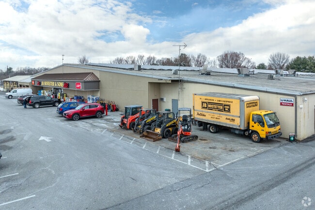
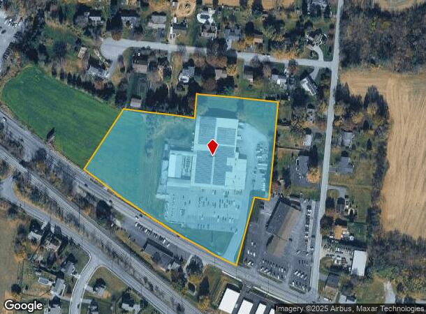
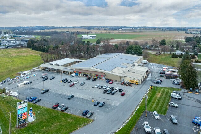
Property Record
1225 W Main St, Mount Joy, PA 17552
NEARBY LISTINGS FOR SALE OR LEASE
Property Detail
1225 W Main St
Commercialnec
Lancaster
X
Pennsylvania
42071C0306F
8.62 AC
2024
Lancaster County
2025
Philadelphia
010602
Lancaster, PA
58,224 SF
461-23082-0-0000
DEMOGRAPHICS near 1225 W Main St
1 Mile
3 Mile
5 Mile
2024 Total Population
4,184
20,100
53,502
2029 Population
4,236
20,248
53,958
Pop Growth 2024-2029
+ 1.24%
+ 0.74%
+ 0.85%
Average Age
39
42
41
2024 Total Households
1,723
8,314
21,140
HH Growth 2024-2029
+ 1.39%
+ 0.82%
+ 0.98%
Median Household Inc
$81,540
$80,289
$76,956
Avg Household Size
2.40
2.40
2.40
2024 Avg HH Vehicles
2.00
2.00
2.00
Median Home Value
$237,819
$254,331
$245,864
Median Year Built
1986
1987
1982
Nearby Places
Map Layers
Map Styles
 Street
 Aerial
- Restaurants
- Banks
- Shops
- Fitness
- Groceries
PUBLIC TRANSPORTATION
COMMUTER RAIL
Mount Joy Amtrak (Keystone Service - Amtrak)
DRIVE
WALK
Distance
Mount Joy Amtrak (Keystone Service - Amtrak)
4 min
1.9 mi
Elizabethtown Amtrak Station (Keystone Service - Amtrak, Pennsylvanian - Amtrak)
DRIVE
WALK
Distance
Elizabethtown Amtrak Station (Keystone Service - Amtrak, Pennsylvanian - Amtrak)
9 min
5.2 mi
AIRPORT
Harrisburg International
DRIVE
WALK
Distance
Harrisburg International
26 min
15.1 mi
Freight Ports
Port of Baltimore
DRIVE
WALK
Distance
Port of Baltimore
108 min
75.2 mi
Nearby Properties
Address
Land Use
TOTAL SIZE
Lot Size
Zoning
Address
Land Use
TOTAL SIZE
Lot Size
Zoning
431,583 SF
24.30 AC
R-2
Address
Land Use
TOTAL SIZE
Lot Size
Zoning
125,610 SF
88.12 AC
A
Address
Land Use
TOTAL SIZE
Lot Size
Zoning
154,112 SF
18.92 AC
Address
Land Use
TOTAL SIZE
Lot Size
Zoning
441,646 SF
59.55 AC
I-2
Address
Land Use
TOTAL SIZE
Lot Size
Zoning
138,828 SF
17.09 AC
Address
Land Use
TOTAL SIZE
Lot Size
Zoning
102,465 SF
17.14 AC
GC
Address
Land Use
TOTAL SIZE
Lot Size
Zoning
128,444 SF
33.65 AC
R-1
Address
Land Use
TOTAL SIZE
Lot Size
Zoning
108,699 SF
65.62 AC
Address
Land Use
TOTAL SIZE
Lot Size
Zoning
120,757 SF
3 AC
TN
Address
Land Use
TOTAL SIZE
Lot Size
Zoning
91,050 SF
30.10 AC
MHDR
Address
Land Use
TOTAL SIZE
Lot Size
Zoning
3,672 SF
176 AC
A
Address
Land Use
TOTAL SIZE
Lot Size
Zoning
4,160 SF
101.10 AC
A
Address
Land Use
TOTAL SIZE
Lot Size
Zoning
37,911 SF
14.40 AC
RT
Address
Land Use
TOTAL SIZE
Lot Size
Zoning
57,780 SF
3.38 AC
R-2
Address
Land Use
TOTAL SIZE
Lot Size
Zoning
46,890 SF
1 AC
MDR
Address
Land Use
TOTAL SIZE
Lot Size
Zoning
61,504 SF
6.64 AC
Address
Land Use
TOTAL SIZE
Lot Size
Zoning
61,606 SF
14.60 AC
A
Address
Land Use
TOTAL SIZE
Lot Size
Zoning
71,425 SF
1 AC
TN
Address
Land Use
TOTAL SIZE
Lot Size
Zoning
71,326 SF
1 AC
TN
Address
Land Use
TOTAL SIZE
Lot Size
Zoning
34,753 SF
10 AC
Address
Land Use
TOTAL SIZE
Lot Size
Zoning
Address
Land Use
TOTAL SIZE
Lot Size
Zoning
99,821 SF
18.10 AC
I
Address
Land Use
TOTAL SIZE
Lot Size
Zoning
47,082 SF
5.30 AC
Address
Land Use
TOTAL SIZE
Lot Size
Zoning
40,468 SF
4.08 AC
Address
Land Use
TOTAL SIZE
Lot Size
Zoning
44,696 SF
4.79 AC
R-3
Address
Land Use
TOTAL SIZE
Lot Size
Zoning
23,763 SF
13 AC
Address
Land Use
TOTAL SIZE
Lot Size
Zoning
52,500 SF
10.02 AC
Address
Land Use
TOTAL SIZE
Lot Size
Zoning
75,570 SF
8 AC
I-2
Address
Land Use
TOTAL SIZE
Lot Size
Zoning
25,730 SF
7.74 AC
C-2
Address
Land Use
TOTAL SIZE
Lot Size
Zoning
56,580 SF
4.30 AC
MHDR
The World's #1 Commercial Real Estate Marketplace
Connect with us
© 2025 CoStar Group
The information above has been obtained from sources believed reliable. While we do not doubt its accuracy we have not verified it and make no guarantee, warranty or representation about it. It is your responsibility to independently confirm its accuracy and completeness. Any projections, opinions, assumptions, or estimates used are for example only and do not represent the current or future performance of the property. The value of this transaction to you depends on tax and other factors which should be evaluated by your tax, financial, and legal advisors. You and your advisors should conduct a careful, independent investigation of the property to determine to your satisfaction the suitability of the property for your needs.