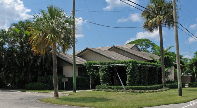
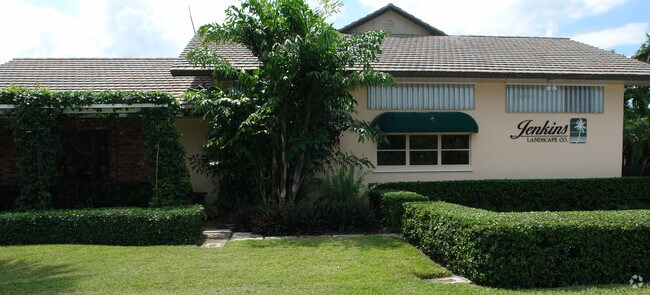
Property Record
12260 Se Dixie Hwy, Hobe Sound, FL 33455
NEARBY LISTINGS FOR SALE OR LEASE
Property Detail
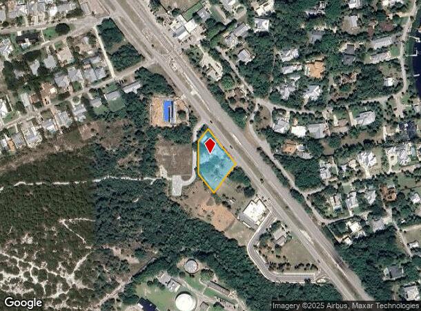
12260 Se Dixie Hwy
Port St Lucie, FL
Hobe Sound
26-39-42-001-002-00010-8
HOBE SOUND AMD PLAT OF BLKS 1-3; ALL OF BLK 2 (LESS THAT PORTION LYING NWLY OF FOLLOWING LINE.. COMM AT NLY COR OF LOT 3 NWLY ALG DIXIE HWY 101.57 FOR POB SWLY PARALLEL S LINE OF BLK 2 75.67 TO W/LN BLK 2 & PT OF TERMINUS (LESS A PORTION OF THE UNNUM
Officebuilding
Martin
X
Florida
12085C0336H
3
2024
0.73 AC
2025
Martin
001500
Port St Lucie/Fort Pierce
4,598 SF
DEMOGRAPHICS near 12260 Se Dixie Hwy
1 Mile
3 Mile
5 Mile
2024 Total Population
2,356
10,847
19,080
2029 Population
2,464
11,483
20,124
Pop Growth 2024-2029
+ 4.58%
+ 5.86%
+ 5.47%
Average Age
53
49
51
2024 Total Households
1,037
4,786
8,919
HH Growth 2024-2029
+ 4.53%
+ 5.83%
+ 5.46%
Median Household Inc
$91,105
$59,893
$58,588
Avg Household Size
2.20
2.20
2.10
2024 Avg HH Vehicles
2.00
2.00
2.00
Median Home Value
$507,500
$377,895
$330,282
Median Year Built
1983
1983
1983
Nearby Places
Map Layers
Map Styles
 Street
 Aerial
- Restaurants
- Banks
- Shops
- Fitness
- Groceries
PUBLIC TRANSPORTATION
AIRPORT
Palm Beach International
DRIVE
WALK
Distance
Palm Beach International
46 min
29.6 mi
Freight Ports
Port of Palm Beach
DRIVE
WALK
Distance
Port of Palm Beach
37 min
20.8 mi
Nearby Properties
Address
Land Use
TOTAL SIZE
Lot Size
Zoning
Address
Land Use
TOTAL SIZE
Lot Size
Zoning
12.96 AC
LC
Address
Land Use
TOTAL SIZE
Lot Size
Zoning
179,145 SF
129.25 AC
RCD
Address
Land Use
TOTAL SIZE
Lot Size
Zoning
12,533 SF
6.48 AC
A80
Address
Land Use
TOTAL SIZE
Lot Size
Zoning
76,319 SF
173.40 AC
PS2
Address
Land Use
TOTAL SIZE
Lot Size
Zoning
149,727 SF
16.82 AC
HB1
Address
Land Use
TOTAL SIZE
Lot Size
Zoning
5,601 SF
1.37 AC
B40
Address
Land Use
TOTAL SIZE
Lot Size
Zoning
7,488 SF
1.95 AC
D25
Address
Land Use
TOTAL SIZE
Lot Size
Zoning
50,015 SF
8.91 AC
RM8
Address
Land Use
TOTAL SIZE
Lot Size
Zoning
85,391 SF
12.47 AC
PUDC
Address
Land Use
TOTAL SIZE
Lot Size
Zoning
4,844 SF
1.61 AC
B40
Address
Land Use
TOTAL SIZE
Lot Size
Zoning
1.64 AC
B40
Address
Land Use
TOTAL SIZE
Lot Size
Zoning
43,832 SF
9.60 AC
RM5
Address
Land Use
TOTAL SIZE
Lot Size
Zoning
6,003 SF
1.83 AC
D25
Address
Land Use
TOTAL SIZE
Lot Size
Zoning
7,554 SF
1.77 AC
F15
Address
Land Use
TOTAL SIZE
Lot Size
Zoning
Address
Land Use
TOTAL SIZE
Lot Size
Zoning
4,321 SF
1.37 AC
B40
Address
Land Use
TOTAL SIZE
Lot Size
Zoning
20,402 SF
13.85 AC
RS6
Address
Land Use
TOTAL SIZE
Lot Size
Zoning
2,988 SF
1.45 AC
B40
Address
Land Use
TOTAL SIZE
Lot Size
Zoning
960 SF
12.34 AC
TP
Address
Land Use
TOTAL SIZE
Lot Size
Zoning
81,911 SF
28.11 AC
PUDR
Address
Land Use
TOTAL SIZE
Lot Size
Zoning
29,608 SF
295.69 AC
RM5
Address
Land Use
TOTAL SIZE
Lot Size
Zoning
4,282 SF
0.64 AC
B40
Address
Land Use
TOTAL SIZE
Lot Size
Zoning
2,242 SF
1.16 AC
A80
Address
Land Use
TOTAL SIZE
Lot Size
Zoning
1,223 SF
1.30 AC
C35
Address
Land Use
TOTAL SIZE
Lot Size
Zoning
15,166 SF
9.41 AC
R3A
Address
Land Use
TOTAL SIZE
Lot Size
Zoning
88,192 SF
21.32 AC
PUDR
Address
Land Use
TOTAL SIZE
Lot Size
Zoning
49,536 SF
8.89 AC
R3A
Address
Land Use
TOTAL SIZE
Lot Size
Zoning
49,725 SF
9.50 AC
R3A
Address
Land Use
TOTAL SIZE
Lot Size
Zoning
0.34 AC
Address
Land Use
TOTAL SIZE
Lot Size
Zoning
2.88 AC
A80
The World's #1 Commercial Real Estate Marketplace
Connect with us
© 2025 CoStar Group
The information above has been obtained from sources believed reliable. While we do not doubt its accuracy we have not verified it and make no guarantee, warranty or representation about it. It is your responsibility to independently confirm its accuracy and completeness. Any projections, opinions, assumptions, or estimates used are for example only and do not represent the current or future performance of the property. The value of this transaction to you depends on tax and other factors which should be evaluated by your tax, financial, and legal advisors. You and your advisors should conduct a careful, independent investigation of the property to determine to your satisfaction the suitability of the property for your needs.