Property Record
1227 Ashley Blvd, New Bedford, MA 02745
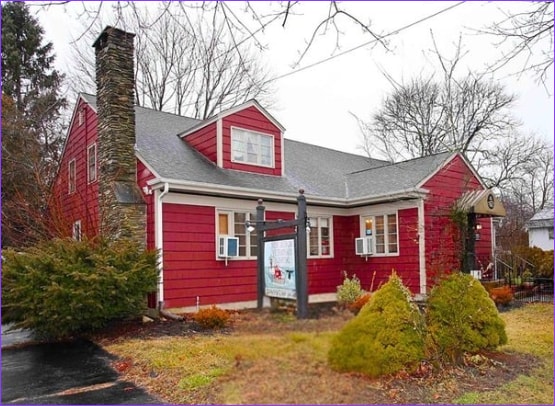

Property Detail
1227 Ashley Blvd
NEWB-000130C-000000-000431
Bristol
Commercialofficeresidentialmixeduse
Massachusetts
MUB
431
B and X Area of moderate flood hazard, usually the area between the limits of the 100-year and 500-year floods.
0.38 AC
0
Attleboro/New Bedford
2025
Boston
650101
Providence-Warwick, RI-MA
3,636 SF
NEARBY LISTINGS FOR SALE OR LEASE
DEMOGRAPHICS near 1227 Ashley Blvd
1 mile
3 mile
5 mile
2025 Total Population
9,181
53,809
110,635
2030 Population
9,306
53,966
110,810
Pop Growth 2025-2030
+ 1.36%
+ 0.29%
+ 0.16%
Average Age
43
40
41
2025 Total Households
3,760
22,021
45,329
HH Growth 2025-2030
+ 1.46%
+ 0.33%
+ 0.16%
Median Household Inc
$80,479
$64,284
$66,076
Avg Household Size
2.40
2.40
2.30
2025 Avg HH Vehicles
2.00
2.00
2.00
Median Home Value
$366,076
$383,969
$398,657
Median Year Built
1967
1952
1950
Nearby Places
Map Layers
Map Styles
 Street
 Aerial
Layers
 Traffic
 Biking
Places
Listings with unknown addresses are not visible on the map
- Restaurants
- Banks
- Shops
- Fitness
- Groceries
PUBLIC TRANSPORTATION
AIRPORT
Rhode Island Tf Green International
Drive
Walk
Distance
Rhode Island Tf Green International
56 min
38.8 mi
SALE & LEASE HISTORY
LISTING DATE
SALE/LEASE

May 26, 2022
For Sale
Feb 28, 2020
For Sale
Feb 04, 2025
For Sale
Dec 07, 2023
For Sale
Aug 20, 2024
For Sale
Nearby Properties
Address
Land Use
TOTAL SIZE
Lot Size
Zoning
Address
Land Use
TOTAL SIZE
Lot Size
Zoning
23.22 AC
RB
Address
Land Use
TOTAL SIZE
Lot Size
Zoning
243,052 SF
9.66 AC
RB
Address
Land Use
TOTAL SIZE
Lot Size
Zoning
102,826 SF
15.15 AC
OI
Address
Land Use
TOTAL SIZE
Lot Size
Zoning
157,346 SF
5.68 AC
RA
Address
Land Use
TOTAL SIZE
Lot Size
Zoning
54.60 AC
Address
Land Use
TOTAL SIZE
Lot Size
Zoning
160,391 SF
2.86 AC
MUB
Address
Land Use
TOTAL SIZE
Lot Size
Zoning
214,698 SF
4.66 AC
IB
Address
Land Use
TOTAL SIZE
Lot Size
Zoning
24.95 AC
PB
Address
Land Use
TOTAL SIZE
Lot Size
Zoning
44,156 SF
5.18 AC
GI
Address
Land Use
TOTAL SIZE
Lot Size
Zoning
11.67 AC
RC
Address
Land Use
TOTAL SIZE
Lot Size
Zoning
134,355 SF
2.21 AC
IB
Address
Land Use
TOTAL SIZE
Lot Size
Zoning
183,196 SF
8.14 AC
MUB
Address
Land Use
TOTAL SIZE
Lot Size
Zoning
492.70 AC
IC
Address
Land Use
TOTAL SIZE
Lot Size
Zoning
119,865 SF
3.22 AC
IA
Address
Land Use
TOTAL SIZE
Lot Size
Zoning
59,778 SF
14.95 AC
OI
Address
Land Use
TOTAL SIZE
Lot Size
Zoning
116,158 SF
3.80 AC
IB
Address
Land Use
TOTAL SIZE
Lot Size
Zoning
225,292 SF
29.27 AC
IC
Address
Land Use
TOTAL SIZE
Lot Size
Zoning
239,765 SF
31.86 AC
IC
Address
Land Use
TOTAL SIZE
Lot Size
Zoning
5,616 SF
132.66 AC
RA
Address
Land Use
TOTAL SIZE
Lot Size
Zoning
306.30 AC
IC
Address
Land Use
TOTAL SIZE
Lot Size
Zoning
6.46 AC
MUB
Address
Land Use
TOTAL SIZE
Lot Size
Zoning
165,183 SF
11.29 AC
PB
Address
Land Use
TOTAL SIZE
Lot Size
Zoning
199,978 SF
31.41 AC
IC
Address
Land Use
TOTAL SIZE
Lot Size
Zoning
169,928 SF
31.88 AC
GI
Address
Land Use
TOTAL SIZE
Lot Size
Zoning
5.49 AC
RB
Address
Land Use
TOTAL SIZE
Lot Size
Zoning
85.25 AC
MUB
Address
Land Use
TOTAL SIZE
Lot Size
Zoning
5.30 AC
RC
Address
Land Use
TOTAL SIZE
Lot Size
Zoning
39,910 SF
2.29 AC
RB
Address
Land Use
TOTAL SIZE
Lot Size
Zoning
381.39 AC
Address
Land Use
TOTAL SIZE
Lot Size
Zoning
9.79 AC
IA
The World's #1 Commercial Real Estate Marketplace
Connect with us
© 2026 CoStar Group
The information above has been obtained from sources believed reliable. While we do not doubt its accuracy we have not verified it and make no guarantee, warranty or representation about it. It is your responsibility to independently confirm its accuracy and completeness. Any projections, opinions, assumptions, or estimates used are for example only and do not represent the current or future performance of the property. The value of this transaction to you depends on tax and other factors which should be evaluated by your tax, financial, and legal advisors. You and your advisors should conduct a careful, independent investigation of the property to determine to your satisfaction the suitability of the property for your needs.