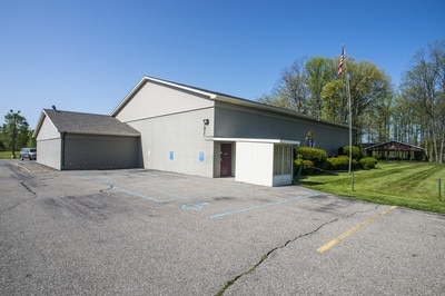
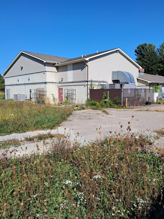
Property Record
1227 W Frances Rd, Mount Morris, MI 48458


Save to a Folder
{{folder.Name}}
{{folder.ListingIds.length}} Properties
{{folder.ListingIds.length}} Property
Create a New Folder
Property Detail
1227 W Frances Rd
14-01-200-021
A PARCEL OF LAND BEG AT N 1/4 COR OF SEC TH N 88 DEG 51 MIN 01 SEC E 490.25 FT TH S 0 DEG 27 MIN 01 SEC W 955 FT TH S 88 DEG
Industrialgeneral
Genesee
B and X Area of moderate flood hazard, usually the area between the limits of the 100-year and 500-year floods.
Michigan
2025
Flint
2025
Detroit
010504
Flint, MI
NEARBY LISTINGS FOR SALE OR LEASE
DEMOGRAPHICS near 1227 W Frances Rd
1 mile
3 mile
5 mile
2025 Total Population
4,463
19,543
53,899
2030 Population
4,543
19,585
54,382
Pop Growth 2025-2030
+ 1.79%
+ 0.21%
+ 0.90%
Average Age
39
41
41
2025 Total Households
1,869
8,034
22,199
HH Growth 2025-2030
+ 1.82%
+ 0.26%
+ 0.90%
Median Household Inc
$53,655
$47,623
$44,514
Avg Household Size
2.30
2.40
2.40
2025 Avg HH Vehicles
2.00
2.00
2.00
Median Home Value
$122,421
$105,675
$115,847
Median Year Built
1964
1966
1965
Nearby Places
Map Layers
Map Styles
 Street
 Aerial
Layers
 Traffic
 Biking
Places
Listings with unknown addresses are not visible on the map
- Restaurants
- Banks
- Shops
- Fitness
- Groceries
PUBLIC TRANSPORTATION
AIRPORT
Bishop International
Drive
Walk
Distance
Bishop International
35 min
18.0 mi
Freight Ports
Port of Toledo
Drive
Walk
Distance
Port of Toledo
150 min
124.6 mi
SALE & LEASE HISTORY
LISTING DATE
SALE/LEASE

Sep 23, 2016
For Sale
Oct 08, 2025
For Sale
Nearby Properties
Address
Land Use
TOTAL SIZE
Lot Size
Zoning
Address
Land Use
TOTAL SIZE
Lot Size
Zoning
2,629 SF
119.59 AC
R-4 MANUF
Address
Land Use
TOTAL SIZE
Lot Size
Zoning
5,242 SF
70.28 AC
MHP
Address
Land Use
TOTAL SIZE
Lot Size
Zoning
94,719 SF
7.55 AC
R-1 SF PUD
Address
Land Use
TOTAL SIZE
Lot Size
Zoning
Address
Land Use
TOTAL SIZE
Lot Size
Zoning
97,998 SF
11.30 AC
R-1 SF PUD
Address
Land Use
TOTAL SIZE
Lot Size
Zoning
7.33 AC
Address
Land Use
TOTAL SIZE
Lot Size
Zoning
77,994 SF
5.68 AC
RU-2
Address
Land Use
TOTAL SIZE
Lot Size
Zoning
76,051 SF
8.31 AC
C-2 HWY CO
Address
Land Use
TOTAL SIZE
Lot Size
Zoning
9,238 SF
84.53 AC
MHP
Address
Land Use
TOTAL SIZE
Lot Size
Zoning
Address
Land Use
TOTAL SIZE
Lot Size
Zoning
10.15 AC
Address
Land Use
TOTAL SIZE
Lot Size
Zoning
54,648 SF
4.68 AC
RU-2
Address
Land Use
TOTAL SIZE
Lot Size
Zoning
1.70 AC
Address
Land Use
TOTAL SIZE
Lot Size
Zoning
2.31 AC
Address
Land Use
TOTAL SIZE
Lot Size
Zoning
49,900 SF
10.17 AC
C-2
Address
Land Use
TOTAL SIZE
Lot Size
Zoning
1,912 SF
64.42 AC
MHP
Address
Land Use
TOTAL SIZE
Lot Size
Zoning
1,430 SF
71.54 AC
R-4 MANUF
Address
Land Use
TOTAL SIZE
Lot Size
Zoning
1,732 SF
0.87 AC
R-1 SF PUD
Address
Land Use
TOTAL SIZE
Lot Size
Zoning
33,200 SF
3.24 AC
I-1 LHGT I
Address
Land Use
TOTAL SIZE
Lot Size
Zoning
Address
Land Use
TOTAL SIZE
Lot Size
Zoning
339 SF
26.24 AC
R-4 MANUF
Address
Land Use
TOTAL SIZE
Lot Size
Zoning
Address
Land Use
TOTAL SIZE
Lot Size
Zoning
9,105 SF
2.29 AC
C-2 HWY CO
Address
Land Use
TOTAL SIZE
Lot Size
Zoning
16,676 SF
31.01 AC
C-2 HWY CO
Address
Land Use
TOTAL SIZE
Lot Size
Zoning
43,650 SF
7 AC
C-2
Address
Land Use
TOTAL SIZE
Lot Size
Zoning
9,600 SF
0.87 AC
GC
Address
Land Use
TOTAL SIZE
Lot Size
Zoning
18,008 SF
7.34 AC
GC
Address
Land Use
TOTAL SIZE
Lot Size
Zoning
Address
Land Use
TOTAL SIZE
Lot Size
Zoning
The World's #1 Commercial Real Estate Marketplace
Connect with us
© 2026 CoStar Group
The information above has been obtained from sources believed reliable. While we do not doubt its accuracy we have not verified it and make no guarantee, warranty or representation about it. It is your responsibility to independently confirm its accuracy and completeness. Any projections, opinions, assumptions, or estimates used are for example only and do not represent the current or future performance of the property. The value of this transaction to you depends on tax and other factors which should be evaluated by your tax, financial, and legal advisors. You and your advisors should conduct a careful, independent investigation of the property to determine to your satisfaction the suitability of the property for your needs.