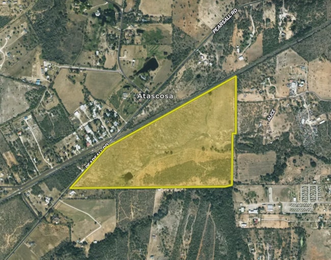
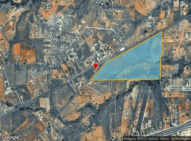
Property Record
12275 Pearsall Rd, Atascosa, TX 78002
NEARBY LISTINGS FOR SALE OR LEASE
Property Detail
12275 Pearsall Rd
San Antonio-New Braunfels, TX
Conv A/S Code
04256-000-0037
CB 4256 P-3 (55.665), P-3B (0.815), P-3C (26.00) ABS 91 2025-MERGE PER CUSTOMER REQ//
Privatepreserveopenspacevacantlandforestlandconservation
Bexar
X
Texas
48029C0540F
37
2024
82.48 AC
2025
South
162004
San Antonio
DEMOGRAPHICS near 12275 Pearsall Rd
1 Mile
3 Mile
5 Mile
2024 Total Population
828
5,708
13,949
2029 Population
875
6,113
15,344
Pop Growth 2024-2029
+ 5.68%
+ 7.10%
+ 10.00%
Average Age
38
38
38
2024 Total Households
242
1,676
4,310
HH Growth 2024-2029
+ 5.79%
+ 7.22%
+ 10.39%
Median Household Inc
$65,510
$66,787
$63,867
Avg Household Size
3.40
3.30
3.20
2024 Avg HH Vehicles
2.00
3.00
2.00
Median Home Value
$272,856
$247,231
$193,468
Median Year Built
1988
1989
1989
Nearby Places
Map Layers
Map Styles
 Street
 Aerial
- Restaurants
- Banks
- Shops
- Fitness
- Groceries
PUBLIC TRANSPORTATION
AIRPORT
San Antonio International
DRIVE
WALK
Distance
San Antonio International
40 min
30.2 mi
Nearby Properties
Address
Land Use
TOTAL SIZE
Lot Size
Zoning
Address
Land Use
TOTAL SIZE
Lot Size
Zoning
160,677 SF
4.48 AC
Address
Land Use
TOTAL SIZE
Lot Size
Zoning
2,030 SF
248.90 AC
Address
Land Use
TOTAL SIZE
Lot Size
Zoning
3,543 SF
87.57 AC
Address
Land Use
TOTAL SIZE
Lot Size
Zoning
868 SF
236.83 AC
Address
Land Use
TOTAL SIZE
Lot Size
Zoning
199.65 AC
Address
Land Use
TOTAL SIZE
Lot Size
Zoning
10,780 SF
2.31 AC
Address
Land Use
TOTAL SIZE
Lot Size
Zoning
90.02 AC
Address
Land Use
TOTAL SIZE
Lot Size
Zoning
5,663 SF
127.02 AC
Address
Land Use
TOTAL SIZE
Lot Size
Zoning
13,204 SF
1.28 AC
Address
Land Use
TOTAL SIZE
Lot Size
Zoning
4,630 SF
12.70 AC
Address
Land Use
TOTAL SIZE
Lot Size
Zoning
6,616 SF
2.25 AC
Address
Land Use
TOTAL SIZE
Lot Size
Zoning
11,362 SF
5.96 AC
Address
Land Use
TOTAL SIZE
Lot Size
Zoning
188.89 AC
Address
Land Use
TOTAL SIZE
Lot Size
Zoning
112.40 AC
Address
Land Use
TOTAL SIZE
Lot Size
Zoning
5,389 SF
10.03 AC
Address
Land Use
TOTAL SIZE
Lot Size
Zoning
150.31 AC
Address
Land Use
TOTAL SIZE
Lot Size
Zoning
12,813 SF
7 AC
Address
Land Use
TOTAL SIZE
Lot Size
Zoning
2,420 SF
40.57 AC
Address
Land Use
TOTAL SIZE
Lot Size
Zoning
6,180 SF
41.74 AC
Address
Land Use
TOTAL SIZE
Lot Size
Zoning
58.35 AC
Address
Land Use
TOTAL SIZE
Lot Size
Zoning
2,764 SF
75.07 AC
Address
Land Use
TOTAL SIZE
Lot Size
Zoning
7,320 SF
11.42 AC
Address
Land Use
TOTAL SIZE
Lot Size
Zoning
1,044 SF
76.96 AC
Address
Land Use
TOTAL SIZE
Lot Size
Zoning
5,280 SF
8.90 AC
Address
Land Use
TOTAL SIZE
Lot Size
Zoning
600 SF
33.35 AC
Address
Land Use
TOTAL SIZE
Lot Size
Zoning
72.30 AC
Address
Land Use
TOTAL SIZE
Lot Size
Zoning
67.42 AC
Address
Land Use
TOTAL SIZE
Lot Size
Zoning
86,560 SF
2.45 AC
Address
Land Use
TOTAL SIZE
Lot Size
Zoning
1,698 SF
45.69 AC
The World's #1 Commercial Real Estate Marketplace
Connect with us
© 2026 CoStar Group
The information above has been obtained from sources believed reliable. While we do not doubt its accuracy we have not verified it and make no guarantee, warranty or representation about it. It is your responsibility to independently confirm its accuracy and completeness. Any projections, opinions, assumptions, or estimates used are for example only and do not represent the current or future performance of the property. The value of this transaction to you depends on tax and other factors which should be evaluated by your tax, financial, and legal advisors. You and your advisors should conduct a careful, independent investigation of the property to determine to your satisfaction the suitability of the property for your needs.