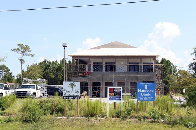
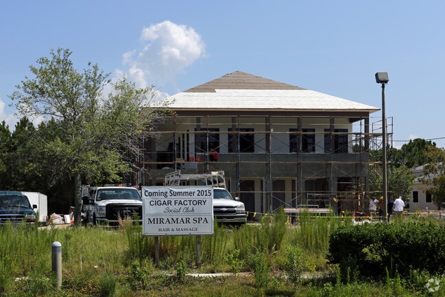
Property Record
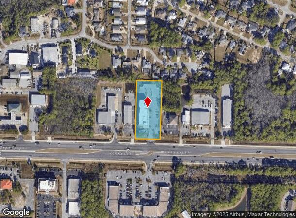
12282 Us Highway 98 W, Miramar Beach, FL 32550

NEARBY LISTINGS FOR SALE OR LEASE
Property Detail
12282 Us Highway 98 W
29-2S-21-42000-011-0018
W 174FT OF: COM SE/C OF NW1/4 OF SEC 29, N 02 DEG 1603E 302.05FT TO N R/W LN OF SR 30, N 87 DEG 2857W ALG N R/W LN 768.38FT ALG N LN N 87 DEG 37 23W 540.18FT TO POB, CONT ALG LAST DESC COURSE 300FT, DPRT N LN N 02 DEG 2437E 400FT S 87 DEG 3723E 300FT
Hotel
Walton
X
Florida
12091C0494J
18
2025
1.60 AC
2025
Fort Walton Beach
950608
Other Market Areas
30,016 SF
Crestview-Fort Walton Beach-Destin, FL
DEMOGRAPHICS near 12282 Us Highway 98 W
1 Mile
3 Mile
5 Mile
2024 Total Population
4,957
16,924
30,746
2029 Population
6,607
21,324
37,997
Pop Growth 2024-2029
+ 33.29%
+ 26.00%
+ 23.58%
Average Age
52
50
48
2024 Total Households
2,489
8,166
14,321
HH Growth 2024-2029
+ 34.23%
+ 27.27%
+ 24.47%
Median Household Inc
$62,388
$78,291
$85,303
Avg Household Size
2.00
2.10
2.10
2024 Avg HH Vehicles
2.00
2.00
2.00
Median Home Value
$481,052
$482,605
$537,640
Median Year Built
1998
1997
2000
Nearby Places
Map Layers
Map Styles
 Street
 Aerial
- Restaurants
- Banks
- Shops
- Fitness
- Groceries
PUBLIC TRANSPORTATION
AIRPORT
Eglin AFB/Destin-Ft Walton Beach
DRIVE
WALK
Distance
Eglin AFB/Destin-Ft Walton Beach
38 min
29.9 mi
Freight Ports
Port of Panama City
DRIVE
WALK
Distance
Port of Panama City
1 min
41.0 mi
Nearby Properties
Address
Land Use
TOTAL SIZE
Lot Size
Zoning
Address
Land Use
TOTAL SIZE
Lot Size
Zoning
429,135 SF
23.38 AC
HWY 98
Address
Land Use
TOTAL SIZE
Lot Size
Zoning
619,795 SF
47.80 AC
Address
Land Use
TOTAL SIZE
Lot Size
Zoning
320,141 SF
16 AC
Address
Land Use
TOTAL SIZE
Lot Size
Zoning
5.19 AC
GULFFR
Address
Land Use
TOTAL SIZE
Lot Size
Zoning
138,905 SF
4.01 AC
Address
Land Use
TOTAL SIZE
Lot Size
Zoning
19,401 SF
6.66 AC
Address
Land Use
TOTAL SIZE
Lot Size
Zoning
118,963 SF
7.58 AC
Address
Land Use
TOTAL SIZE
Lot Size
Zoning
74,662 SF
6.02 AC
HWY 98
Address
Land Use
TOTAL SIZE
Lot Size
Zoning
195,622 SF
17.68 AC
Address
Land Use
TOTAL SIZE
Lot Size
Zoning
65,340 SF
1.01 AC
CCMU
Address
Land Use
TOTAL SIZE
Lot Size
Zoning
66,001 SF
1.25 AC
HWY 98
Address
Land Use
TOTAL SIZE
Lot Size
Zoning
113,053 SF
7.25 AC
Address
Land Use
TOTAL SIZE
Lot Size
Zoning
1.81 AC
GULFFR
Address
Land Use
TOTAL SIZE
Lot Size
Zoning
123,120 SF
4.11 AC
HWY 98
Address
Land Use
TOTAL SIZE
Lot Size
Zoning
7,416 SF
25.45 AC
HWY 98
Address
Land Use
TOTAL SIZE
Lot Size
Zoning
154,725 SF
15.69 AC
Address
Land Use
TOTAL SIZE
Lot Size
Zoning
68,849 SF
6.75 AC
HWY 98
Address
Land Use
TOTAL SIZE
Lot Size
Zoning
50,665 SF
5.47 AC
Address
Land Use
TOTAL SIZE
Lot Size
Zoning
89,369 SF
6.54 AC
HWY 98
Address
Land Use
TOTAL SIZE
Lot Size
Zoning
69,744 SF
4.12 AC
Address
Land Use
TOTAL SIZE
Lot Size
Zoning
44,504 SF
1.84 AC
HWY 98
Address
Land Use
TOTAL SIZE
Lot Size
Zoning
36,414 SF
2.18 AC
Address
Land Use
TOTAL SIZE
Lot Size
Zoning
8,086 SF
104.35 AC
HWY 98
Address
Land Use
TOTAL SIZE
Lot Size
Zoning
18,480 SF
1.50 AC
HWY 98
Address
Land Use
TOTAL SIZE
Lot Size
Zoning
12,269 SF
0.76 AC
GULFFR
Address
Land Use
TOTAL SIZE
Lot Size
Zoning
30,824 SF
1.93 AC
HWY 98
Address
Land Use
TOTAL SIZE
Lot Size
Zoning
46,402 SF
1.42 AC
Address
Land Use
TOTAL SIZE
Lot Size
Zoning
26,470 SF
1.84 AC
HWY 98
Address
Land Use
TOTAL SIZE
Lot Size
Zoning
50,918 SF
2 AC
The World's #1 Commercial Real Estate Marketplace
Connect with us
© 2025 CoStar Group
The information above has been obtained from sources believed reliable. While we do not doubt its accuracy we have not verified it and make no guarantee, warranty or representation about it. It is your responsibility to independently confirm its accuracy and completeness. Any projections, opinions, assumptions, or estimates used are for example only and do not represent the current or future performance of the property. The value of this transaction to you depends on tax and other factors which should be evaluated by your tax, financial, and legal advisors. You and your advisors should conduct a careful, independent investigation of the property to determine to your satisfaction the suitability of the property for your needs.