Property Record
12285 Patterson Ave, Richmond, VA 23238

NEARBY LISTINGS FOR SALE OR LEASE
Property Detail
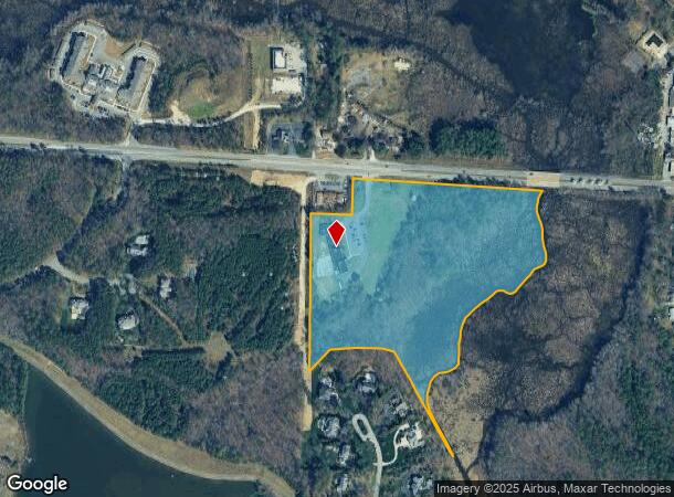
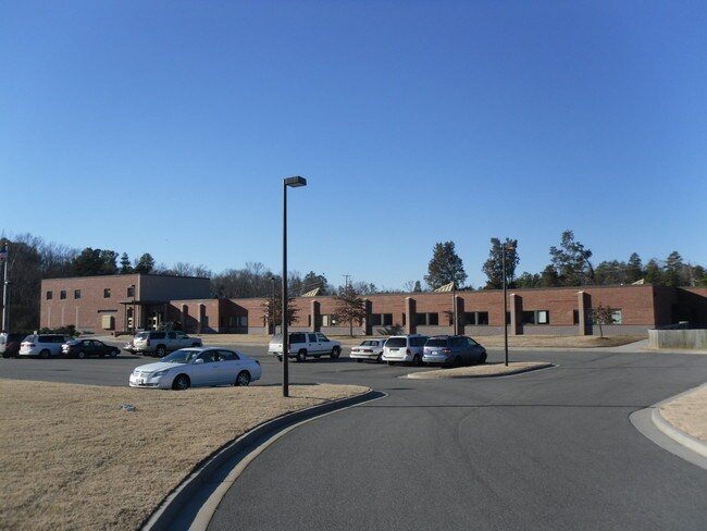
12285 Patterson Ave
64-1-77A
Collage View
Privateschool
E OF MANAKIN ON 6 20.43AC #13-3544
AE
Goochland
51075C0307C
Virginia
2025
20.43 AC
2025
West Creek
400101
Richmond VA
17,257 SF
Richmond, VA
DEMOGRAPHICS near 12285 Patterson Ave
1 Mile
3 Mile
5 Mile
2024 Total Population
3,924
46,750
129,493
2029 Population
4,043
46,942
131,561
Pop Growth 2024-2029
+ 3.03%
+ 0.41%
+ 1.60%
Average Age
48
43
41
2024 Total Households
1,752
19,192
51,053
HH Growth 2024-2029
+ 2.80%
+ 0.45%
+ 1.56%
Median Household Inc
$81,917
$100,354
$106,079
Avg Household Size
2.10
2.40
2.40
2024 Avg HH Vehicles
2.00
2.00
2.00
Median Home Value
$479,347
$402,145
$462,139
Median Year Built
1980
1984
1986
Nearby Places
Map Layers
Map Styles
 Street
 Aerial
- Restaurants
- Banks
- Shops
- Fitness
- Groceries
PUBLIC TRANSPORTATION
COMMUTER RAIL
DRIVE
WALK
Distance
16 min
8.4 mi
AIRPORT
Richmond International
DRIVE
WALK
Distance
Richmond International
37 min
22.6 mi
Freight Ports
Virginia Port Authority - Richmond
DRIVE
WALK
Distance
Virginia Port Authority - Richmond
35 min
20.9 mi
Nearby Properties
Address
Land Use
TOTAL SIZE
Lot Size
Zoning
Address
Land Use
TOTAL SIZE
Lot Size
Zoning
22.47 AC
M1-INDUS/L
Address
Land Use
TOTAL SIZE
Lot Size
Zoning
230,955 SF
48.48 AC
MIXE
Address
Land Use
TOTAL SIZE
Lot Size
Zoning
18 AC
M1-INDUS/L
Address
Land Use
TOTAL SIZE
Lot Size
Zoning
577,728 SF
34.86 AC
R-5
Address
Land Use
TOTAL SIZE
Lot Size
Zoning
34,065 SF
33.21 AC
R-1
Address
Land Use
TOTAL SIZE
Lot Size
Zoning
268,461 SF
17.09 AC
R-5
Address
Land Use
TOTAL SIZE
Lot Size
Zoning
311,196 SF
27.62 AC
R-5
Address
Land Use
TOTAL SIZE
Lot Size
Zoning
26,163 SF
12.02 AC
A-1
Address
Land Use
TOTAL SIZE
Lot Size
Zoning
109,096 SF
50.05 AC
A2R1-AG LT
Address
Land Use
TOTAL SIZE
Lot Size
Zoning
352,296 SF
23.62 AC
R-5
Address
Land Use
TOTAL SIZE
Lot Size
Zoning
271,263 SF
18.81 AC
MIXE
Address
Land Use
TOTAL SIZE
Lot Size
Zoning
179,920 SF
16.23 AC
R-5
Address
Land Use
TOTAL SIZE
Lot Size
Zoning
1,456 SF
11.71 AC
R-5
Address
Land Use
TOTAL SIZE
Lot Size
Zoning
220,895 SF
77.14 AC
A-1
Address
Land Use
TOTAL SIZE
Lot Size
Zoning
176,520 SF
17.61 AC
R-5
Address
Land Use
TOTAL SIZE
Lot Size
Zoning
35.54 AC
B1-BUS/GEN
Address
Land Use
TOTAL SIZE
Lot Size
Zoning
104,758 SF
15.92 AC
R-5
Address
Land Use
TOTAL SIZE
Lot Size
Zoning
97,890 SF
9.87 AC
R-6
Address
Land Use
TOTAL SIZE
Lot Size
Zoning
219,450 SF
27.74 AC
M1-INDUS/L
Address
Land Use
TOTAL SIZE
Lot Size
Zoning
68,641 SF
6.39 AC
R-1
Address
Land Use
TOTAL SIZE
Lot Size
Zoning
227 AC
M1-INDUS/L
Address
Land Use
TOTAL SIZE
Lot Size
Zoning
161,031 SF
41.88 AC
A-1
Address
Land Use
TOTAL SIZE
Lot Size
Zoning
215,252 SF
17.88 AC
R-5
Address
Land Use
TOTAL SIZE
Lot Size
Zoning
72,230 SF
16.66 AC
R-5
Address
Land Use
TOTAL SIZE
Lot Size
Zoning
102,476 SF
5.41 AC
R-5
Address
Land Use
TOTAL SIZE
Lot Size
Zoning
45,990 SF
35.98 AC
A2-AG/LTD
Address
Land Use
TOTAL SIZE
Lot Size
Zoning
74,444 SF
7.70 AC
R-6C
Address
Land Use
TOTAL SIZE
Lot Size
Zoning
64,040 SF
8.39 AC
R-5
Address
Land Use
TOTAL SIZE
Lot Size
Zoning
1,968 SF
31.93 AC
MIXE
Address
Land Use
TOTAL SIZE
Lot Size
Zoning
107,832 SF
10.26 AC
R-5
The World's #1 Commercial Real Estate Marketplace
Connect with us
© 2026 CoStar Group
The information above has been obtained from sources believed reliable. While we do not doubt its accuracy we have not verified it and make no guarantee, warranty or representation about it. It is your responsibility to independently confirm its accuracy and completeness. Any projections, opinions, assumptions, or estimates used are for example only and do not represent the current or future performance of the property. The value of this transaction to you depends on tax and other factors which should be evaluated by your tax, financial, and legal advisors. You and your advisors should conduct a careful, independent investigation of the property to determine to your satisfaction the suitability of the property for your needs.