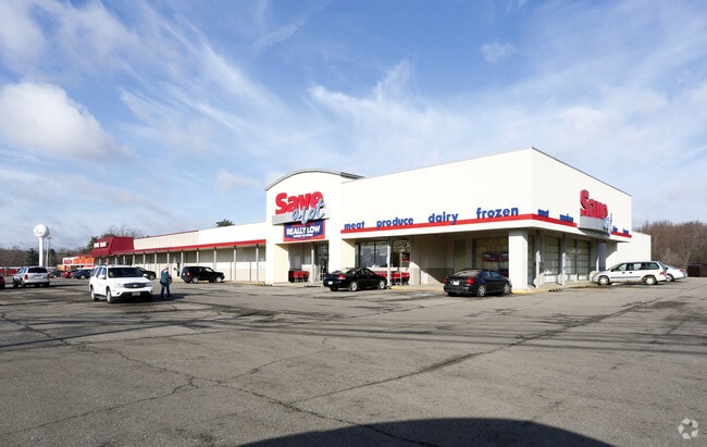
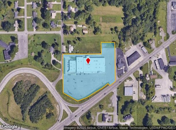
Property Record
1229 Ashland Rd, Mansfield, OH 44905
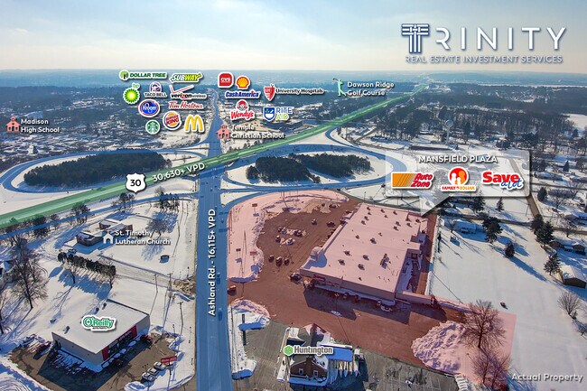
NEARBY LISTINGS FOR SALE OR LEASE
Property Detail
1229 Ashland Rd
025-09-041-02-000
NNW 5.303 AC SUBJ HWY EASE
Supermarket
Richland
X
Ohio
39139C0163E
5.30 AC
2024
Richland County
2024
Cleveland
001800
Mansfield, OH
43,356 SF
DEMOGRAPHICS near 1229 Ashland Rd
1 Mile
3 Mile
5 Mile
2024 Total Population
4,584
25,351
59,209
2029 Population
4,594
25,441
59,618
Pop Growth 2024-2029
+ 0.22%
+ 0.36%
+ 0.69%
Average Age
41
40
40
2024 Total Households
1,919
8,400
23,293
HH Growth 2024-2029
+ 0.21%
+ 0.39%
+ 0.70%
Median Household Inc
$50,264
$45,954
$39,514
Avg Household Size
2.20
2.30
2.20
2024 Avg HH Vehicles
2.00
2.00
2.00
Median Home Value
$109,369
$104,343
$97,556
Median Year Built
1964
1960
1958
Nearby Places
Map Layers
Map Styles
 Street
 Aerial
- Restaurants
- Banks
- Shops
- Fitness
- Groceries
SALE & LEASE HISTORY
LISTING DATE
SALE/LEASE

Sep 24, 2016
For Sale
Nov 29, 2018
For Sale
Nov 01, 2018
For Sale
Mar 02, 2021
For Sale
Dec 28, 2016
For Sale
Nearby Properties
Address
Land Use
TOTAL SIZE
Lot Size
Zoning
Address
Land Use
TOTAL SIZE
Lot Size
Zoning
456.50 AC
Address
Land Use
TOTAL SIZE
Lot Size
Zoning
114,931 SF
17.86 AC
Address
Land Use
TOTAL SIZE
Lot Size
Zoning
0.06 AC
Address
Land Use
TOTAL SIZE
Lot Size
Zoning
148,135 SF
6.89 AC
Address
Land Use
TOTAL SIZE
Lot Size
Zoning
2.31 AC
Address
Land Use
TOTAL SIZE
Lot Size
Zoning
404,200 SF
14.77 AC
Address
Land Use
TOTAL SIZE
Lot Size
Zoning
221,864 SF
20 AC
Address
Land Use
TOTAL SIZE
Lot Size
Zoning
107,456 SF
50.78 AC
Address
Land Use
TOTAL SIZE
Lot Size
Zoning
318,366 SF
26.16 AC
Address
Land Use
TOTAL SIZE
Lot Size
Zoning
52.67 AC
Address
Land Use
TOTAL SIZE
Lot Size
Zoning
1.69 AC
Address
Land Use
TOTAL SIZE
Lot Size
Zoning
28,638 SF
24.86 AC
Address
Land Use
TOTAL SIZE
Lot Size
Zoning
44,718 SF
0.47 AC
Address
Land Use
TOTAL SIZE
Lot Size
Zoning
30,306 SF
5.63 AC
Address
Land Use
TOTAL SIZE
Lot Size
Zoning
106,361 SF
5.06 AC
Address
Land Use
TOTAL SIZE
Lot Size
Zoning
75,157 SF
0.41 AC
Address
Land Use
TOTAL SIZE
Lot Size
Zoning
31,064 SF
9 AC
Address
Land Use
TOTAL SIZE
Lot Size
Zoning
103,000 SF
17.38 AC
Address
Land Use
TOTAL SIZE
Lot Size
Zoning
163,292 SF
16.76 AC
Address
Land Use
TOTAL SIZE
Lot Size
Zoning
70,665 SF
10.56 AC
Address
Land Use
TOTAL SIZE
Lot Size
Zoning
80,000 SF
12.10 AC
Address
Land Use
TOTAL SIZE
Lot Size
Zoning
46,040 SF
8.57 AC
Address
Land Use
TOTAL SIZE
Lot Size
Zoning
138,116 SF
21.57 AC
Address
Land Use
TOTAL SIZE
Lot Size
Zoning
78,014 SF
3.50 AC
Address
Land Use
TOTAL SIZE
Lot Size
Zoning
28,157 SF
5.31 AC
Address
Land Use
TOTAL SIZE
Lot Size
Zoning
56,505 SF
3.89 AC
Address
Land Use
TOTAL SIZE
Lot Size
Zoning
101,000 SF
5.81 AC
Address
Land Use
TOTAL SIZE
Lot Size
Zoning
243,123 SF
11.09 AC
Address
Land Use
TOTAL SIZE
Lot Size
Zoning
84,336 SF
6.42 AC
The World's #1 Commercial Real Estate Marketplace
Connect with us
© 2026 CoStar Group
The information above has been obtained from sources believed reliable. While we do not doubt its accuracy we have not verified it and make no guarantee, warranty or representation about it. It is your responsibility to independently confirm its accuracy and completeness. Any projections, opinions, assumptions, or estimates used are for example only and do not represent the current or future performance of the property. The value of this transaction to you depends on tax and other factors which should be evaluated by your tax, financial, and legal advisors. You and your advisors should conduct a careful, independent investigation of the property to determine to your satisfaction the suitability of the property for your needs.