Property Record
1229 S Main St, Bryan, OH 43506
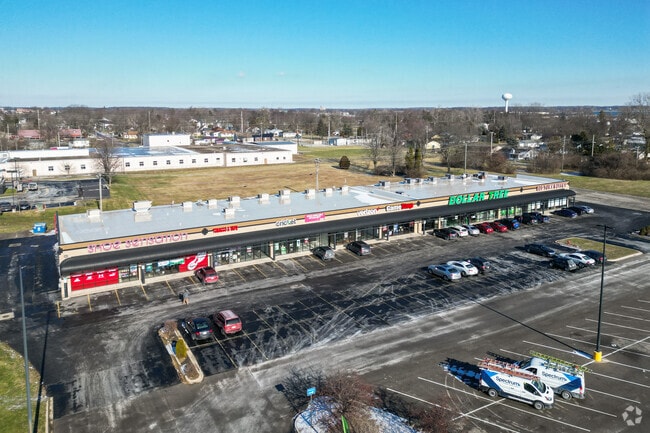

Property Detail
1229 S Main St
063-200-36-018.001
R.3 T.6 S.20 OL 91 N 200'
Departmentstore
Williams
2025
Ohio
2025
2.74 AC
950600
Ohio North Area
27,880 SF
Other Market Areas
NEARBY LISTINGS FOR SALE OR LEASE
-
-
View all Bryan listings for sale on LoopNet.com
DEMOGRAPHICS near 1229 S Main St
1 mile
3 mile
5 mile
2025 Total Population
4,768
11,112
13,884
2030 Population
4,745
11,050
13,814
Pop Growth 2025-2030
(0.48%)
(0.56%)
(0.50%)
Average Age
41
42
42
2025 Total Households
2,069
4,889
5,985
HH Growth 2025-2030
(0.53%)
(0.61%)
(0.55%)
Median Household Inc
$54,489
$54,201
$58,525
Avg Household Size
2.20
2.20
2.30
2025 Avg HH Vehicles
2.00
2.00
2.00
Median Home Value
$174,766
$159,393
$167,176
Median Year Built
1964
1967
1968
Nearby Places
Map Layers
Map Styles
 Street
 Aerial
Layers
 Traffic
 Biking
Places
Listings with unknown addresses are not visible on the map
- Restaurants
- Banks
- Shops
- Fitness
- Groceries
PUBLIC TRANSPORTATION
COMMUTER RAIL
Bryan Amtrak Station (Lake Shore Limited - Amtrak)
Drive
Walk
Distance
Bryan Amtrak Station (Lake Shore Limited - Amtrak)
4 min
1.8 mi
Freight Ports
Port of Toledo
Drive
Walk
Distance
Port of Toledo
93 min
68.5 mi
SALE & LEASE HISTORY
LISTING DATE
SALE/LEASE

Sep 25, 2016
For Lease
Oct 31, 2017
For Sale
Oct 17, 2017
For Sale
Mar 23, 2017
For Sale
Jul 13, 2017
For Sale
Jan 03, 2025
For Sale
Aug 20, 2018
For Sale
Aug 02, 2017
For Lease
Nearby Properties
Address
Land Use
TOTAL SIZE
Lot Size
Zoning
Address
Land Use
TOTAL SIZE
Lot Size
Zoning
93,783 SF
4.10 AC
Address
Land Use
TOTAL SIZE
Lot Size
Zoning
130,297 SF
72.61 AC
Address
Land Use
TOTAL SIZE
Lot Size
Zoning
8,070 SF
52.87 AC
Address
Land Use
TOTAL SIZE
Lot Size
Zoning
7.50 AC
Address
Land Use
TOTAL SIZE
Lot Size
Zoning
220,935 SF
7.13 AC
Address
Land Use
TOTAL SIZE
Lot Size
Zoning
46,916 SF
5.04 AC
Address
Land Use
TOTAL SIZE
Lot Size
Zoning
2,532 SF
20 AC
Address
Land Use
TOTAL SIZE
Lot Size
Zoning
28,196 SF
3.85 AC
Address
Land Use
TOTAL SIZE
Lot Size
Zoning
6,992 SF
4.04 AC
Address
Land Use
TOTAL SIZE
Lot Size
Zoning
193,440 SF
9.31 AC
Address
Land Use
TOTAL SIZE
Lot Size
Zoning
1,644 SF
18.36 AC
Address
Land Use
TOTAL SIZE
Lot Size
Zoning
12,000 SF
31.09 AC
Address
Land Use
TOTAL SIZE
Lot Size
Zoning
37,720 SF
4.57 AC
Address
Land Use
TOTAL SIZE
Lot Size
Zoning
22,722 SF
2.83 AC
Address
Land Use
TOTAL SIZE
Lot Size
Zoning
26,454 SF
5.75 AC
Address
Land Use
TOTAL SIZE
Lot Size
Zoning
1,029 SF
8.65 AC
Address
Land Use
TOTAL SIZE
Lot Size
Zoning
20,004 SF
2.58 AC
Address
Land Use
TOTAL SIZE
Lot Size
Zoning
78.02 AC
Address
Land Use
TOTAL SIZE
Lot Size
Zoning
75,514 SF
2.46 AC
Address
Land Use
TOTAL SIZE
Lot Size
Zoning
51,025 SF
1.11 AC
Address
Land Use
TOTAL SIZE
Lot Size
Zoning
74,580 SF
9.67 AC
Address
Land Use
TOTAL SIZE
Lot Size
Zoning
57,576 SF
1.75 AC
Address
Land Use
TOTAL SIZE
Lot Size
Zoning
66,086 SF
19.92 AC
Address
Land Use
TOTAL SIZE
Lot Size
Zoning
34,000 SF
3.51 AC
Address
Land Use
TOTAL SIZE
Lot Size
Zoning
4,342 SF
2.31 AC
Address
Land Use
TOTAL SIZE
Lot Size
Zoning
21,924 SF
4.13 AC
Address
Land Use
TOTAL SIZE
Lot Size
Zoning
34,794 SF
2.62 AC
Address
Land Use
TOTAL SIZE
Lot Size
Zoning
46,832 SF
5.07 AC
Address
Land Use
TOTAL SIZE
Lot Size
Zoning
11,872 SF
1.64 AC
Address
Land Use
TOTAL SIZE
Lot Size
Zoning
27,520 SF
6 AC
The World's #1 Commercial Real Estate Marketplace
Connect with us
© 2026 CoStar Group
The information above has been obtained from sources believed reliable. While we do not doubt its accuracy we have not verified it and make no guarantee, warranty or representation about it. It is your responsibility to independently confirm its accuracy and completeness. Any projections, opinions, assumptions, or estimates used are for example only and do not represent the current or future performance of the property. The value of this transaction to you depends on tax and other factors which should be evaluated by your tax, financial, and legal advisors. You and your advisors should conduct a careful, independent investigation of the property to determine to your satisfaction the suitability of the property for your needs.