Property Record
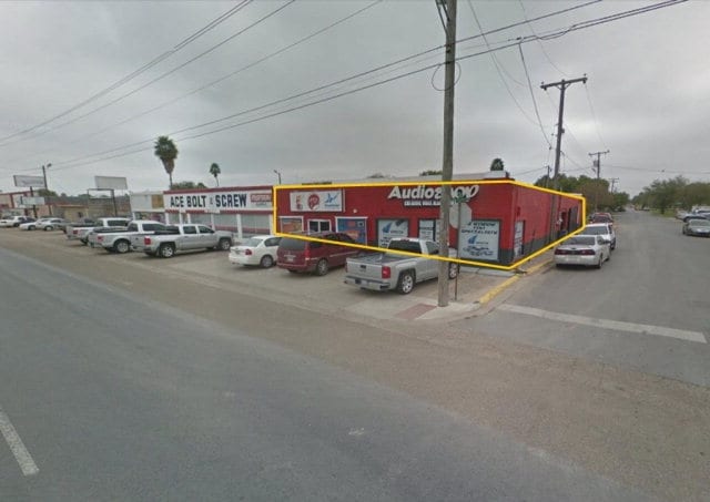
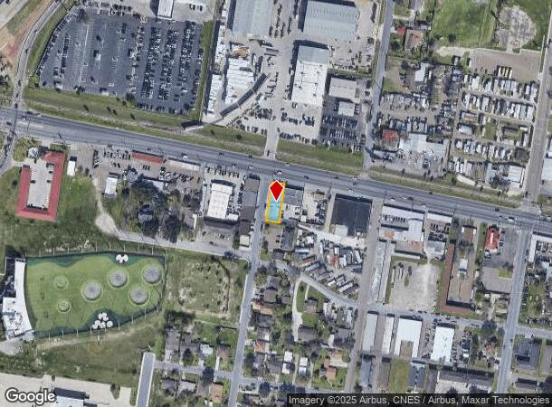
1229 W Us Highway 83, Pharr, TX 78577
NEARBY LISTINGS FOR SALE OR LEASE
Property Detail
1229 W Us Highway 83
McAllen/Edinburg/Pharr
Kelly Pharr Tract - Seb
McAllen-Edinburg-Mission, TX
KELLY PHARR TRACT E70.07-W362.07-N161.25 LOT 177 0.26AC GR 0.17AC NET
K2400-00-000-0177-13
Hidalgo
Commercialnec
Texas
2024
177
2025
0.17 AC
021401
Pharr
4,300 SF
DEMOGRAPHICS near 1229 W Us Highway 83
1 Mile
3 Mile
5 Mile
2024 Total Population
10,006
105,630
242,202
2029 Population
10,613
112,724
256,455
Pop Growth 2024-2029
+ 6.07%
+ 6.72%
+ 5.88%
Average Age
35
37
35
2024 Total Households
3,495
35,970
78,477
HH Growth 2024-2029
+ 6.01%
+ 6.78%
+ 5.91%
Median Household Inc
$29,307
$43,874
$44,490
Avg Household Size
2.80
2.80
3.00
2024 Avg HH Vehicles
1.00
2.00
2.00
Median Home Value
$92,952
$117,055
$124,850
Median Year Built
1987
1994
1996
Nearby Places
Map Layers
Map Styles
 Street
 Aerial
- Restaurants
- Banks
- Shops
- Fitness
- Groceries
PUBLIC TRANSPORTATION
AIRPORT
McAllen International
DRIVE
WALK
Distance
McAllen International
8 min
3.6 mi
Valley International
DRIVE
WALK
Distance
Valley International
57 min
39.4 mi
Freight Ports
Port of Brownsville
DRIVE
WALK
Distance
Port of Brownsville
66 min
57.7 mi
SALE & LEASE HISTORY
LISTING DATE
SALE/LEASE

Jun 13, 2017
For Sale
Nearby Properties
Address
Land Use
TOTAL SIZE
Lot Size
Zoning
Address
Land Use
TOTAL SIZE
Lot Size
Zoning
1,199,590 SF
47.93 AC
Address
Land Use
TOTAL SIZE
Lot Size
Zoning
430,216 SF
18.66 AC
CO
Address
Land Use
TOTAL SIZE
Lot Size
Zoning
347,628 SF
13.03 AC
CO
Address
Land Use
TOTAL SIZE
Lot Size
Zoning
291,859 SF
10.11 AC
CO
Address
Land Use
TOTAL SIZE
Lot Size
Zoning
1 SF
24.90 AC
Address
Land Use
TOTAL SIZE
Lot Size
Zoning
390,048 SF
30.30 AC
Address
Land Use
TOTAL SIZE
Lot Size
Zoning
323,769 SF
62.11 AC
Address
Land Use
TOTAL SIZE
Lot Size
Zoning
2 SF
38 AC
RS
Address
Land Use
TOTAL SIZE
Lot Size
Zoning
1 SF
9.36 AC
Address
Land Use
TOTAL SIZE
Lot Size
Zoning
191,978 SF
2.22 AC
Address
Land Use
TOTAL SIZE
Lot Size
Zoning
252,435 SF
9.09 AC
Address
Land Use
TOTAL SIZE
Lot Size
Zoning
216,315 SF
3.19 AC
CO
Address
Land Use
TOTAL SIZE
Lot Size
Zoning
1 SF
39.94 AC
CO
Address
Land Use
TOTAL SIZE
Lot Size
Zoning
7.50 AC
Address
Land Use
TOTAL SIZE
Lot Size
Zoning
202,204 SF
19.43 AC
Address
Land Use
TOTAL SIZE
Lot Size
Zoning
236,124 SF
14.03 AC
Address
Land Use
TOTAL SIZE
Lot Size
Zoning
39,603 SF
3.95 AC
Address
Land Use
TOTAL SIZE
Lot Size
Zoning
15,542 SF
34.23 AC
Address
Land Use
TOTAL SIZE
Lot Size
Zoning
115,998 SF
6.73 AC
Address
Land Use
TOTAL SIZE
Lot Size
Zoning
140,904 SF
33.98 AC
Address
Land Use
TOTAL SIZE
Lot Size
Zoning
254,477 SF
51.88 AC
Address
Land Use
TOTAL SIZE
Lot Size
Zoning
79,150 SF
10.24 AC
Address
Land Use
TOTAL SIZE
Lot Size
Zoning
123,548 SF
10.70 AC
Address
Land Use
TOTAL SIZE
Lot Size
Zoning
135,948 SF
2.87 AC
Address
Land Use
TOTAL SIZE
Lot Size
Zoning
84,335 SF
5.79 AC
CO
Address
Land Use
TOTAL SIZE
Lot Size
Zoning
2 SF
92.29 AC
CO
Address
Land Use
TOTAL SIZE
Lot Size
Zoning
121,353 SF
4.59 AC
Address
Land Use
TOTAL SIZE
Lot Size
Zoning
13,632 SF
17 AC
Address
Land Use
TOTAL SIZE
Lot Size
Zoning
66,605 SF
10.05 AC
Address
Land Use
TOTAL SIZE
Lot Size
Zoning
16.83 AC
CO
The World's #1 Commercial Real Estate Marketplace
Connect with us
© 2025 CoStar Group
The information above has been obtained from sources believed reliable. While we do not doubt its accuracy we have not verified it and make no guarantee, warranty or representation about it. It is your responsibility to independently confirm its accuracy and completeness. Any projections, opinions, assumptions, or estimates used are for example only and do not represent the current or future performance of the property. The value of this transaction to you depends on tax and other factors which should be evaluated by your tax, financial, and legal advisors. You and your advisors should conduct a careful, independent investigation of the property to determine to your satisfaction the suitability of the property for your needs.