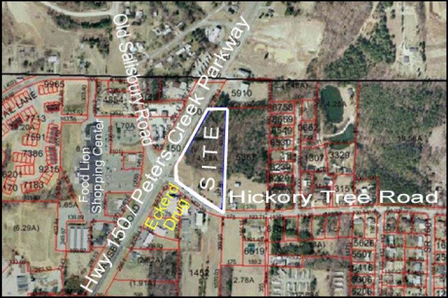
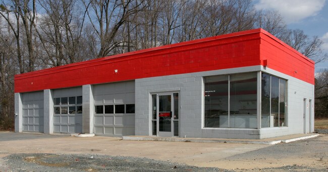
Property Record
12290 N Nc Highway 150, Winston Salem, NC 27127

Property Detail
12290 N Nc Highway 150
03-003-0-000-0021-0-0-0
L21 BK2153-2424 TRACT A NC 150
Conveniencestore
Davidson
HC
North Carolina
B and X Area of moderate flood hazard, usually the area between the limits of the 100-year and 500-year floods.
1.75 AC
2025
North Davidson County
2025
Greensboro/Winston-Salem
060203
Winston-Salem, NC
6,688 SF
NEARBY LISTINGS FOR SALE OR LEASE
DEMOGRAPHICS near 12290 N Nc Highway 150
1 mile
3 mile
5 mile
2025 Total Population
3,274
28,408
72,249
2030 Population
3,415
29,526
74,788
Pop Growth 2025-2030
+ 4.31%
+ 3.94%
+ 3.51%
Average Age
42
41
40
2025 Total Households
1,388
11,372
29,739
HH Growth 2025-2030
+ 4.47%
+ 4.09%
+ 3.61%
Median Household Inc
$64,666
$75,299
$67,355
Avg Household Size
2.30
2.40
2.40
2025 Avg HH Vehicles
2.00
2.00
2.00
Median Home Value
$281,769
$253,779
$240,875
Median Year Built
2001
2000
1993
Nearby Places
Map Layers
Map Styles
 Street
 Aerial
Layers
 Traffic
 Biking
Places
Listings with unknown addresses are not visible on the map
- Restaurants
- Banks
- Shops
- Fitness
- Groceries
PUBLIC TRANSPORTATION
AIRPORT
Piedmont Triad International
Drive
Walk
Distance
Piedmont Triad International
40 min
28.4 mi
Nearby Properties
Address
Land Use
TOTAL SIZE
Lot Size
Zoning
Address
Land Use
TOTAL SIZE
Lot Size
Zoning
198,730 SF
37.41 AC
RS9
Address
Land Use
TOTAL SIZE
Lot Size
Zoning
211,658 SF
27.33 AC
MRB-S
Address
Land Use
TOTAL SIZE
Lot Size
Zoning
79,734 SF
22.54 AC
RM12-S
Address
Land Use
TOTAL SIZE
Lot Size
Zoning
59,612 SF
10.91 AC
MU-S
Address
Land Use
TOTAL SIZE
Lot Size
Zoning
57,837 SF
9.45 AC
RM18-S
Address
Land Use
TOTAL SIZE
Lot Size
Zoning
48,620 SF
15.51 AC
RM12-S
Address
Land Use
TOTAL SIZE
Lot Size
Zoning
992,551 SF
72.46 AC
GI
Address
Land Use
TOTAL SIZE
Lot Size
Zoning
139,248 SF
27.24 AC
MRB-S
Address
Land Use
TOTAL SIZE
Lot Size
Zoning
77,143 SF
12.09 AC
NSB-S
Address
Land Use
TOTAL SIZE
Lot Size
Zoning
87,041 SF
44 AC
RA3
Address
Land Use
TOTAL SIZE
Lot Size
Zoning
77,048 SF
7.76 AC
HC
Address
Land Use
TOTAL SIZE
Lot Size
Zoning
48,831 SF
2.83 AC
GB-S
Address
Land Use
TOTAL SIZE
Lot Size
Zoning
35,395 SF
3.72 AC
MRB-S
Address
Land Use
TOTAL SIZE
Lot Size
Zoning
35,206 SF
4 AC
CS
Address
Land Use
TOTAL SIZE
Lot Size
Zoning
199,441 SF
7.08 AC
LI
Address
Land Use
TOTAL SIZE
Lot Size
Zoning
10,416 SF
7.25 AC
PDH
Address
Land Use
TOTAL SIZE
Lot Size
Zoning
36,917 SF
11.10 AC
RM8-S
Address
Land Use
TOTAL SIZE
Lot Size
Zoning
39,110 SF
5.01 AC
IP,RS9
Address
Land Use
TOTAL SIZE
Lot Size
Zoning
82,020 SF
6.18 AC
RM12-S
Address
Land Use
TOTAL SIZE
Lot Size
Zoning
20,658 SF
33.25 AC
RS
Address
Land Use
TOTAL SIZE
Lot Size
Zoning
16,334 SF
1.88 AC
HC
Address
Land Use
TOTAL SIZE
Lot Size
Zoning
35,869 SF
3.44 AC
IP
Address
Land Use
TOTAL SIZE
Lot Size
Zoning
24,909 SF
5.32 AC
RM18
Address
Land Use
TOTAL SIZE
Lot Size
Zoning
13,607 SF
1.39 AC
MRB-S
Address
Land Use
TOTAL SIZE
Lot Size
Zoning
6,544 SF
1.73 AC
MRB-S
Address
Land Use
TOTAL SIZE
Lot Size
Zoning
4,752 SF
1.47 AC
MRB-S
Address
Land Use
TOTAL SIZE
Lot Size
Zoning
16,648 SF
10.23 AC
GB,HB
Address
Land Use
TOTAL SIZE
Lot Size
Zoning
20,172 SF
2.41 AC
PDHC
Address
Land Use
TOTAL SIZE
Lot Size
Zoning
4,000 SF
9.35 AC
HC
Address
Land Use
TOTAL SIZE
Lot Size
Zoning
7,281 SF
HI
The World's #1 Commercial Real Estate Marketplace
Connect with us
© 2026 CoStar Group
The information above has been obtained from sources believed reliable. While we do not doubt its accuracy we have not verified it and make no guarantee, warranty or representation about it. It is your responsibility to independently confirm its accuracy and completeness. Any projections, opinions, assumptions, or estimates used are for example only and do not represent the current or future performance of the property. The value of this transaction to you depends on tax and other factors which should be evaluated by your tax, financial, and legal advisors. You and your advisors should conduct a careful, independent investigation of the property to determine to your satisfaction the suitability of the property for your needs.