Property Record
6530 122Nd Ave, Kenosha, WI 53142

This Property Is For Sale
NEARBY LISTINGS FOR SALE OR LEASE
Property Detail
6530 122Nd Ave
Chicago-Naperville-Elgin, IL-IN-WI
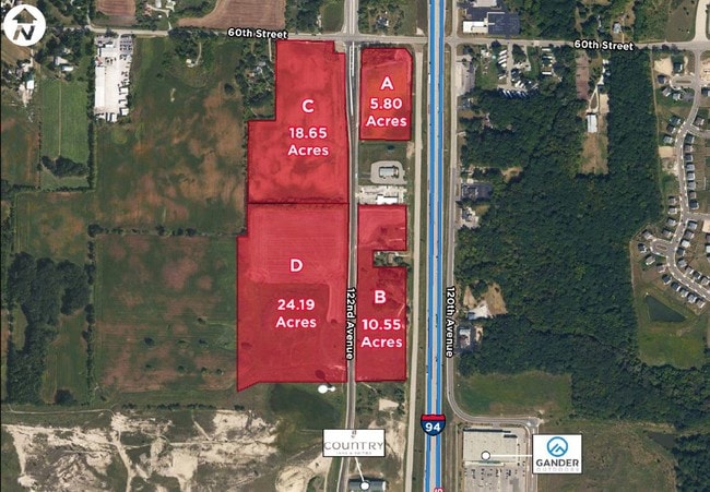
THAT PT OF FOLLOWING LYING W OF 122ND AVE ROW AS DESCRIBED IN DOC#1634242 TPP 09-1024-4.02 PT NE 1/4 SEC 1 T 1 R 21 COM AT E
03-121-01-101-423
Kenosha
Taxexempt
Wisconsin
X
0
55059C0179D
24.19 AC
0
Kenosha East
2024
Chicago
002500
DEMOGRAPHICS near 6530 122Nd Ave
1 Mile
3 Mile
5 Mile
2024 Total Population
2,592
16,680
41,477
2029 Population
2,605
16,758
41,421
Pop Growth 2024-2029
+ 0.50%
+ 0.47%
(0.14%)
Average Age
37
39
40
2024 Total Households
892
6,363
16,113
HH Growth 2024-2029
+ 0.56%
+ 0.50%
(0.17%)
Median Household Inc
$98,458
$92,855
$81,559
Avg Household Size
2.90
2.60
2.50
2024 Avg HH Vehicles
2.00
2.00
2.00
Median Home Value
$322,222
$296,949
$262,812
Median Year Built
1999
2000
1990
Nearby Places
Map Layers
Map Styles
 Street
 Aerial
- Restaurants
- Banks
- Shops
- Fitness
- Groceries
PUBLIC TRANSPORTATION
COMMUTER RAIL
Kenosha Station (Union Pacific North Line - Northeast Illinois Regional Commuter Railroad (Metra))
DRIVE
WALK
Distance
Kenosha Station (Union Pacific North Line - Northeast Illinois Regional Commuter Railroad (Metra))
15 min
7.8 mi
AIRPORT
General Mitchell International
DRIVE
WALK
Distance
General Mitchell International
29 min
27.4 mi
Freight Ports
Port of Baltimore
DRIVE
WALK
Distance
Port of Baltimore
1 min
635.1 mi
Nearby Properties
Address
Land Use
TOTAL SIZE
Lot Size
Zoning
Address
Land Use
TOTAL SIZE
Lot Size
Zoning
159,194 SF
136.60 AC
Address
Land Use
TOTAL SIZE
Lot Size
Zoning
1,015,740 SF
113.58 AC
C2
Address
Land Use
TOTAL SIZE
Lot Size
Zoning
2,565 SF
65.18 AC
Address
Land Use
TOTAL SIZE
Lot Size
Zoning
58.93 AC
Address
Land Use
TOTAL SIZE
Lot Size
Zoning
731,186 SF
81.94 AC
M2
Address
Land Use
TOTAL SIZE
Lot Size
Zoning
68.19 AC
Address
Land Use
TOTAL SIZE
Lot Size
Zoning
67.63 AC
FW
Address
Land Use
TOTAL SIZE
Lot Size
Zoning
12,876 SF
30.13 AC
Address
Land Use
TOTAL SIZE
Lot Size
Zoning
77.22 AC
Address
Land Use
TOTAL SIZE
Lot Size
Zoning
481,854 SF
84.10 AC
FW
Address
Land Use
TOTAL SIZE
Lot Size
Zoning
48.22 AC
Address
Land Use
TOTAL SIZE
Lot Size
Zoning
35.73 AC
M2
Address
Land Use
TOTAL SIZE
Lot Size
Zoning
57.67 AC
Address
Land Use
TOTAL SIZE
Lot Size
Zoning
44.09 AC
Address
Land Use
TOTAL SIZE
Lot Size
Zoning
1,467 SF
50.67 AC
Address
Land Use
TOTAL SIZE
Lot Size
Zoning
513,760 SF
48.61 AC
C1
Address
Land Use
TOTAL SIZE
Lot Size
Zoning
424,072 SF
29.14 AC
Address
Land Use
TOTAL SIZE
Lot Size
Zoning
16.01 AC
Address
Land Use
TOTAL SIZE
Lot Size
Zoning
418,036 SF
25.33 AC
Address
Land Use
TOTAL SIZE
Lot Size
Zoning
47.82 AC
Address
Land Use
TOTAL SIZE
Lot Size
Zoning
850,230 SF
39.46 AC
M2
Address
Land Use
TOTAL SIZE
Lot Size
Zoning
447,200 SF
23.50 AC
Address
Land Use
TOTAL SIZE
Lot Size
Zoning
626,520 SF
35.19 AC
M2
Address
Land Use
TOTAL SIZE
Lot Size
Zoning
13.10 AC
Address
Land Use
TOTAL SIZE
Lot Size
Zoning
20.33 AC
M2
Address
Land Use
TOTAL SIZE
Lot Size
Zoning
31,809 SF
11.36 AC
BASE
Address
Land Use
TOTAL SIZE
Lot Size
Zoning
50,145 SF
12.76 AC
Address
Land Use
TOTAL SIZE
Lot Size
Zoning
4,643 SF
60 AC
Address
Land Use
TOTAL SIZE
Lot Size
Zoning
35.18 AC
M2
Address
Land Use
TOTAL SIZE
Lot Size
Zoning
55,140 SF
21 AC
FW
The World's #1 Commercial Real Estate Marketplace
Connect with us
© 2025 CoStar Group
The information above has been obtained from sources believed reliable. While we do not doubt its accuracy we have not verified it and make no guarantee, warranty or representation about it. It is your responsibility to independently confirm its accuracy and completeness. Any projections, opinions, assumptions, or estimates used are for example only and do not represent the current or future performance of the property. The value of this transaction to you depends on tax and other factors which should be evaluated by your tax, financial, and legal advisors. You and your advisors should conduct a careful, independent investigation of the property to determine to your satisfaction the suitability of the property for your needs.