Property Record
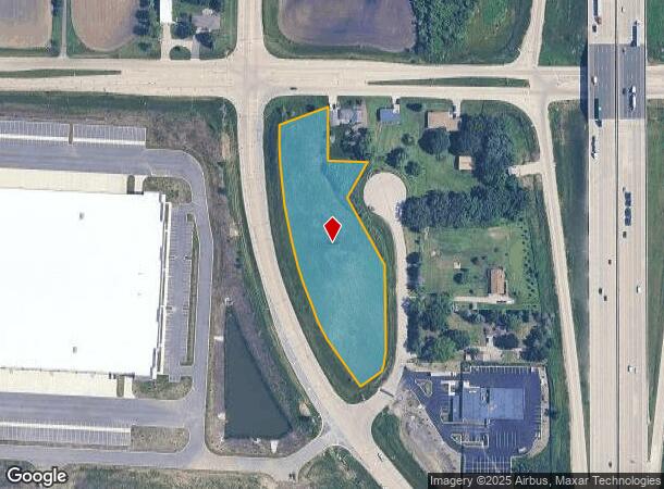
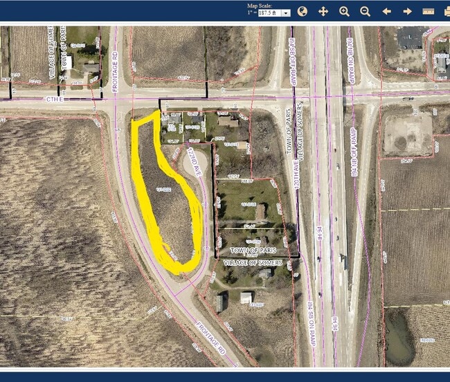
122Nd Ave, Union Grove, WI 53182

NEARBY LISTINGS FOR SALE OR LEASE
Property Detail
122Nd Ave
82-4-221-131-0202
N 1/2 OF NE 1/4 SEC 13 T 1 R 21 T 1 R 21 PROP LOCATED E OF PARCEL 1 TPP 1030-23-20-4.01 EXC N 208 FT & EXC E 390 FT & PROP SE
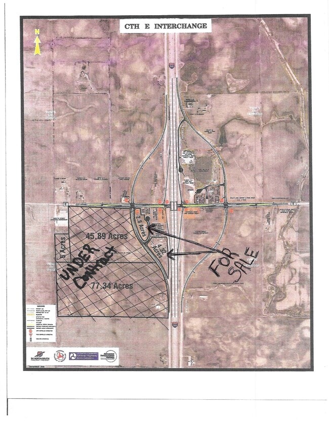
Agriculturalland
Kenosha
X
Wisconsin
55101C0183D
2.80 AC
2024
Kenosha East
2024
Chicago
001801
Chicago-Naperville-Elgin, IL-IN-WI
DEMOGRAPHICS near 122Nd Ave
1 Mile
3 Mile
5 Mile
2024 Total Population
104
2,333
21,350
2029 Population
101
2,309
21,354
Pop Growth 2024-2029
(2.88%)
(1.03%)
+ 0.02%
Average Age
46
46
40
2024 Total Households
43
1,042
7,882
HH Growth 2024-2029
(2.33%)
(0.96%)
(0.06%)
Median Household Inc
$78,125
$70,300
$94,929
Avg Household Size
2.30
2.20
2.60
2024 Avg HH Vehicles
2.00
2.00
2.00
Median Home Value
$407,143
$278,139
$279,670
Median Year Built
1966
1975
1995
Nearby Places
Map Layers
Map Styles
 Street
 Aerial
- Restaurants
- Banks
- Shops
- Fitness
- Groceries
PUBLIC TRANSPORTATION
COMMUTER RAIL
Sturtevant Amtrak Station (Hiawatha Service - Amtrak)
DRIVE
WALK
Distance
Sturtevant Amtrak Station (Hiawatha Service - Amtrak)
12 min
8.7 mi
Kenosha Station (Union Pacific North Line - Northeast Illinois Regional Commuter Railroad (Metra))
DRIVE
WALK
Distance
Kenosha Station (Union Pacific North Line - Northeast Illinois Regional Commuter Railroad (Metra))
18 min
9.9 mi
AIRPORT
General Mitchell International
DRIVE
WALK
Distance
General Mitchell International
28 min
23.4 mi
Freight Ports
Port Milwaukee
DRIVE
WALK
Distance
Port Milwaukee
33 min
27.3 mi
SALE & LEASE HISTORY
LISTING DATE
SALE/LEASE

Sep 03, 2021
For Sale
Nearby Properties
Address
Land Use
TOTAL SIZE
Lot Size
Zoning
Address
Land Use
TOTAL SIZE
Lot Size
Zoning
861.42 AC
Address
Land Use
TOTAL SIZE
Lot Size
Zoning
1,015,740 SF
113.58 AC
C2
Address
Land Use
TOTAL SIZE
Lot Size
Zoning
2,565 SF
65.18 AC
Address
Land Use
TOTAL SIZE
Lot Size
Zoning
58.93 AC
Address
Land Use
TOTAL SIZE
Lot Size
Zoning
68.19 AC
Address
Land Use
TOTAL SIZE
Lot Size
Zoning
67.63 AC
FW
Address
Land Use
TOTAL SIZE
Lot Size
Zoning
795,471 SF
49.72 AC
Address
Land Use
TOTAL SIZE
Lot Size
Zoning
77.22 AC
Address
Land Use
TOTAL SIZE
Lot Size
Zoning
481,854 SF
84.10 AC
FW
Address
Land Use
TOTAL SIZE
Lot Size
Zoning
48.22 AC
Address
Land Use
TOTAL SIZE
Lot Size
Zoning
35.73 AC
M2
Address
Land Use
TOTAL SIZE
Lot Size
Zoning
43.56 AC
Address
Land Use
TOTAL SIZE
Lot Size
Zoning
44.09 AC
Address
Land Use
TOTAL SIZE
Lot Size
Zoning
1,467 SF
50.67 AC
Address
Land Use
TOTAL SIZE
Lot Size
Zoning
513,760 SF
48.61 AC
C1
Address
Land Use
TOTAL SIZE
Lot Size
Zoning
509,017 SF
34.37 AC
Address
Land Use
TOTAL SIZE
Lot Size
Zoning
35.18 AC
M2
Address
Land Use
TOTAL SIZE
Lot Size
Zoning
81.82 AC
Address
Land Use
TOTAL SIZE
Lot Size
Zoning
72.29 AC
Address
Land Use
TOTAL SIZE
Lot Size
Zoning
14,576 SF
25.05 AC
Address
Land Use
TOTAL SIZE
Lot Size
Zoning
43.43 AC
Address
Land Use
TOTAL SIZE
Lot Size
Zoning
20,872 SF
8.08 AC
Address
Land Use
TOTAL SIZE
Lot Size
Zoning
12,425 SF
15.11 AC
Address
Land Use
TOTAL SIZE
Lot Size
Zoning
25,920 SF
243.33 AC
Address
Land Use
TOTAL SIZE
Lot Size
Zoning
17,024 SF
2.38 AC
Address
Land Use
TOTAL SIZE
Lot Size
Zoning
9.85 AC
Address
Land Use
TOTAL SIZE
Lot Size
Zoning
621 SF
22.40 AC
Address
Land Use
TOTAL SIZE
Lot Size
Zoning
4,581 SF
36.78 AC
Address
Land Use
TOTAL SIZE
Lot Size
Zoning
77.94 AC
Address
Land Use
TOTAL SIZE
Lot Size
Zoning
4,624 SF
1.04 AC
The World's #1 Commercial Real Estate Marketplace
Connect with us
© 2025 CoStar Group
The information above has been obtained from sources believed reliable. While we do not doubt its accuracy we have not verified it and make no guarantee, warranty or representation about it. It is your responsibility to independently confirm its accuracy and completeness. Any projections, opinions, assumptions, or estimates used are for example only and do not represent the current or future performance of the property. The value of this transaction to you depends on tax and other factors which should be evaluated by your tax, financial, and legal advisors. You and your advisors should conduct a careful, independent investigation of the property to determine to your satisfaction the suitability of the property for your needs.