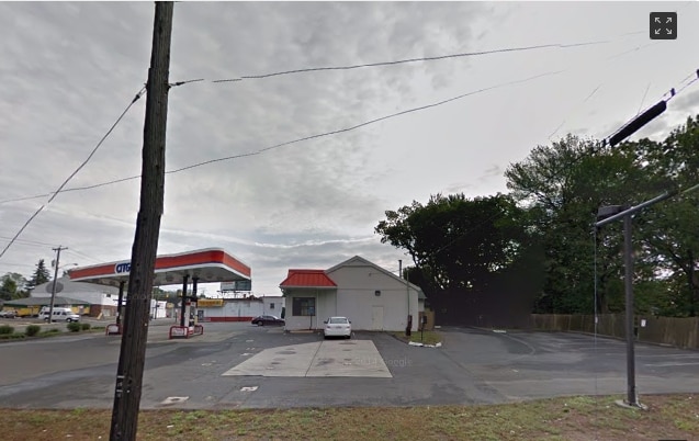
Property Record
123 Boston Rd, Springfield, MA 01109

Property Detail
123 Boston Rd
Servicestation
HAMPDEN
B1
Massachusetts
B and X Area of moderate flood hazard, usually the area between the limits of the 100-year and 500-year floods.
0.58 AC
2025
Hampden County
2025
Hartford
801402
Springfield, MA
2,138 SF
SPRI-001655-000000-000743
NEARBY LISTINGS FOR SALE OR LEASE
DEMOGRAPHICS near 123 Boston Rd
1 mile
3 mile
5 mile
2025 Total Population
11,583
118,270
239,785
2030 Population
11,687
118,077
239,710
Pop Growth 2025-2030
+ 0.90%
(0.16%)
(0.03%)
Average Age
40
38
40
2025 Total Households
4,362
43,700
94,003
HH Growth 2025-2030
+ 0.80%
(0.20%)
(0.03%)
Median Household Inc
$50,827
$53,307
$57,786
Avg Household Size
2.50
2.50
2.40
2025 Avg HH Vehicles
2.00
1.00
1.00
Median Home Value
$228,494
$251,033
$274,908
Median Year Built
1955
1951
1954
Nearby Places
Map Layers
Map Styles
 Street
 Aerial
Layers
 Traffic
 Biking
Places
Listings with unknown addresses are not visible on the map
- Restaurants
- Banks
- Shops
- Fitness
- Groceries
PUBLIC TRANSPORTATION
COMMUTER RAIL
Drive
Walk
Distance
6 min
3.8 mi
Drive
Walk
Distance
14 min
7.7 mi
AIRPORT
Bradley International
Drive
Walk
Distance
Bradley International
34 min
17.0 mi
Worcester Regional
Drive
Walk
Distance
Worcester Regional
71 min
49.1 mi
SALE & LEASE HISTORY
LISTING DATE
SALE/LEASE

Oct 23, 2019
For Sale
Nearby Properties
Address
Land Use
TOTAL SIZE
Lot Size
Zoning
Address
Land Use
TOTAL SIZE
Lot Size
Zoning
89,312 SF
38.72 AC
R1
Address
Land Use
TOTAL SIZE
Lot Size
Zoning
263,462 SF
21.65 AC
R2
Address
Land Use
TOTAL SIZE
Lot Size
Zoning
44,886 SF
2.69 AC
R2
Address
Land Use
TOTAL SIZE
Lot Size
Zoning
178,132 SF
15.60 AC
B1
Address
Land Use
TOTAL SIZE
Lot Size
Zoning
209,471 SF
2.98 AC
SR3C1
Address
Land Use
TOTAL SIZE
Lot Size
Zoning
207,383 SF
37.44 AC
R6
Address
Land Use
TOTAL SIZE
Lot Size
Zoning
51,808 SF
11.01 AC
SR2B1
Address
Land Use
TOTAL SIZE
Lot Size
Zoning
48,924 SF
40.03 AC
I2
Address
Land Use
TOTAL SIZE
Lot Size
Zoning
431,476 SF
88.64 AC
SC2B1
Address
Land Use
TOTAL SIZE
Lot Size
Zoning
141,970 SF
4.34 AC
S
Address
Land Use
TOTAL SIZE
Lot Size
Zoning
56,576 SF
62.84 AC
SR1R4
Address
Land Use
TOTAL SIZE
Lot Size
Zoning
112,378 SF
3.03 AC
R2
Address
Land Use
TOTAL SIZE
Lot Size
Zoning
7.41 AC
I2
Address
Land Use
TOTAL SIZE
Lot Size
Zoning
1.89 AC
SR2I2
Address
Land Use
TOTAL SIZE
Lot Size
Zoning
131,942 SF
40.30 AC
R1
Address
Land Use
TOTAL SIZE
Lot Size
Zoning
36,446 SF
25 AC
R1
Address
Land Use
TOTAL SIZE
Lot Size
Zoning
82,248 SF
4.57 AC
SR3C1
Address
Land Use
TOTAL SIZE
Lot Size
Zoning
153,742 SF
22.34 AC
R1
Address
Land Use
TOTAL SIZE
Lot Size
Zoning
75,000 SF
3.10 AC
B1
Address
Land Use
TOTAL SIZE
Lot Size
Zoning
181,000 SF
34.48 AC
I1
Address
Land Use
TOTAL SIZE
Lot Size
Zoning
219,521 SF
7.50 AC
R2
Address
Land Use
TOTAL SIZE
Lot Size
Zoning
105,494 SF
2.33 AC
I2
Address
Land Use
TOTAL SIZE
Lot Size
Zoning
39,776 SF
8.16 AC
R2
Address
Land Use
TOTAL SIZE
Lot Size
Zoning
24,835 SF
2.16 AC
B3
Address
Land Use
TOTAL SIZE
Lot Size
Zoning
36.60 AC
SR2C1
Address
Land Use
TOTAL SIZE
Lot Size
Zoning
5,802 SF
49.19 AC
R2
Address
Land Use
TOTAL SIZE
Lot Size
Zoning
196,530 SF
19.74 AC
SR1C1
Address
Land Use
TOTAL SIZE
Lot Size
Zoning
102,932 SF
60.01 AC
R6
Address
Land Use
TOTAL SIZE
Lot Size
Zoning
2,555 SF
166.42 AC
RB
Address
Land Use
TOTAL SIZE
Lot Size
Zoning
60,620 SF
4.96 AC
SR3B1
The World's #1 Commercial Real Estate Marketplace
Connect with us
© 2026 CoStar Group
The information above has been obtained from sources believed reliable. While we do not doubt its accuracy we have not verified it and make no guarantee, warranty or representation about it. It is your responsibility to independently confirm its accuracy and completeness. Any projections, opinions, assumptions, or estimates used are for example only and do not represent the current or future performance of the property. The value of this transaction to you depends on tax and other factors which should be evaluated by your tax, financial, and legal advisors. You and your advisors should conduct a careful, independent investigation of the property to determine to your satisfaction the suitability of the property for your needs.