Property Record
123 King Rd E, Ithaca, NY 14850
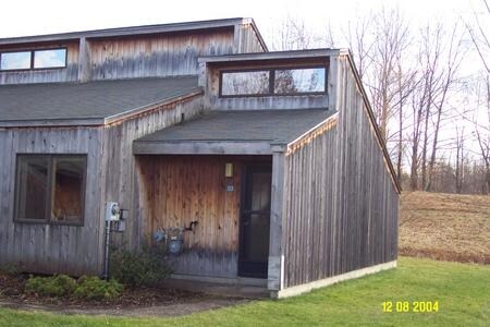

Property Detail
123 King Rd E
503089-043-000-0002-008-000-0000
Tompkins
Apartment
New York
B and X Area of moderate flood hazard, usually the area between the limits of the 100-year and 500-year floods.
8.000
2025
15.44 AC
2025
South Hill Ithaca
001100
Other Market Areas
3,779 SF
Ithaca, NY
NEARBY LISTINGS FOR SALE OR LEASE
DEMOGRAPHICS near 123 King Rd E
1 mile
3 mile
5 mile
2025 Total Population
1,712
37,801
62,746
2030 Population
1,754
37,756
62,953
Pop Growth 2025-2030
+ 2.45%
(0.12%)
+ 0.33%
Average Age
37
34
35
2025 Total Households
605
14,655
23,380
HH Growth 2025-2030
+ 3.47%
(0.23%)
+ 0.29%
Median Household Inc
$55,208
$48,659
$60,763
Avg Household Size
2.10
2.00
2.00
2025 Avg HH Vehicles
1.00
1.00
1.00
Median Home Value
$308,696
$311,142
$330,854
Median Year Built
1982
1972
1974
Nearby Places
Map Layers
Map Styles
 Street
 Aerial
Layers
 Traffic
 Biking
Places
Listings with unknown addresses are not visible on the map
- Restaurants
- Banks
- Shops
- Fitness
- Groceries
PUBLIC TRANSPORTATION
AIRPORT
Ithaca Tompkins International
Drive
Walk
Distance
Ithaca Tompkins International
16 min
8.3 mi
Elmira/Corning Regional
Drive
Walk
Distance
Elmira/Corning Regional
51 min
36.9 mi
Freight Ports
Albany, NY Port
Drive
Walk
Distance
Albany, NY Port
220 min
165.9 mi
Nearby Properties
Address
Land Use
TOTAL SIZE
Lot Size
Zoning
Address
Land Use
TOTAL SIZE
Lot Size
Zoning
5,000 SF
154.28 AC
U-1
Address
Land Use
TOTAL SIZE
Lot Size
Zoning
2,212,226 SF
588.22 AC
Address
Land Use
TOTAL SIZE
Lot Size
Zoning
338,706 SF
2.08 AC
U-1
Address
Land Use
TOTAL SIZE
Lot Size
Zoning
276,302 SF
15.94 AC
Address
Land Use
TOTAL SIZE
Lot Size
Zoning
1.30 AC
U-1
Address
Land Use
TOTAL SIZE
Lot Size
Zoning
50,319 SF
25.92 AC
Address
Land Use
TOTAL SIZE
Lot Size
Zoning
218,211 SF
0.76 AC
CBD-60
Address
Land Use
TOTAL SIZE
Lot Size
Zoning
4,400 SF
30.50 AC
Address
Land Use
TOTAL SIZE
Lot Size
Zoning
125,988 SF
0.61 AC
CBD-60
Address
Land Use
TOTAL SIZE
Lot Size
Zoning
199,578 SF
0.56 AC
CBD-60
Address
Land Use
TOTAL SIZE
Lot Size
Zoning
8,100 SF
0.51 AC
CBD-60
Address
Land Use
TOTAL SIZE
Lot Size
Zoning
0.93 AC
U-1
Address
Land Use
TOTAL SIZE
Lot Size
Zoning
228,978 SF
4.96 AC
Address
Land Use
TOTAL SIZE
Lot Size
Zoning
3,000 SF
97.73 AC
Address
Land Use
TOTAL SIZE
Lot Size
Zoning
112,392 SF
0.79 AC
B-2B
Address
Land Use
TOTAL SIZE
Lot Size
Zoning
185,997 SF
0.65 AC
CBD-140
Address
Land Use
TOTAL SIZE
Lot Size
Zoning
26,658 SF
0.69 AC
R-3A
Address
Land Use
TOTAL SIZE
Lot Size
Zoning
91,872 SF
0.76 AC
R-3B
Address
Land Use
TOTAL SIZE
Lot Size
Zoning
114,085 SF
0.77 AC
B-2C
Address
Land Use
TOTAL SIZE
Lot Size
Zoning
75,861 SF
0.97 AC
B-2B
Address
Land Use
TOTAL SIZE
Lot Size
Zoning
171,299 SF
3.59 AC
Address
Land Use
TOTAL SIZE
Lot Size
Zoning
43,592 SF
1.71 AC
P-1
Address
Land Use
TOTAL SIZE
Lot Size
Zoning
59,626 SF
0.65 AC
R-3B
Address
Land Use
TOTAL SIZE
Lot Size
Zoning
64,708 SF
1.13 AC
B-2C
Address
Land Use
TOTAL SIZE
Lot Size
Zoning
7,434 SF
1.28 AC
P-1
Address
Land Use
TOTAL SIZE
Lot Size
Zoning
97,500 SF
0.82 AC
I-1
Address
Land Use
TOTAL SIZE
Lot Size
Zoning
24,673 SF
0.38 AC
B-2B
Address
Land Use
TOTAL SIZE
Lot Size
Zoning
67,641 SF
0.52 AC
B-2B
Address
Land Use
TOTAL SIZE
Lot Size
Zoning
74,900 SF
15.60 AC
R-3A
Address
Land Use
TOTAL SIZE
Lot Size
Zoning
222,572 SF
0.92 AC
CBD-100
The World's #1 Commercial Real Estate Marketplace
Connect with us
© 2026 CoStar Group
The information above has been obtained from sources believed reliable. While we do not doubt its accuracy we have not verified it and make no guarantee, warranty or representation about it. It is your responsibility to independently confirm its accuracy and completeness. Any projections, opinions, assumptions, or estimates used are for example only and do not represent the current or future performance of the property. The value of this transaction to you depends on tax and other factors which should be evaluated by your tax, financial, and legal advisors. You and your advisors should conduct a careful, independent investigation of the property to determine to your satisfaction the suitability of the property for your needs.