Property Record
123 Maple Ave, Cedarhurst, NY 11516

Save to a Folder
{{folder.Name}}
{{folder.ListingIds.length}} Properties
{{folder.ListingIds.length}} Property
Create a New Folder
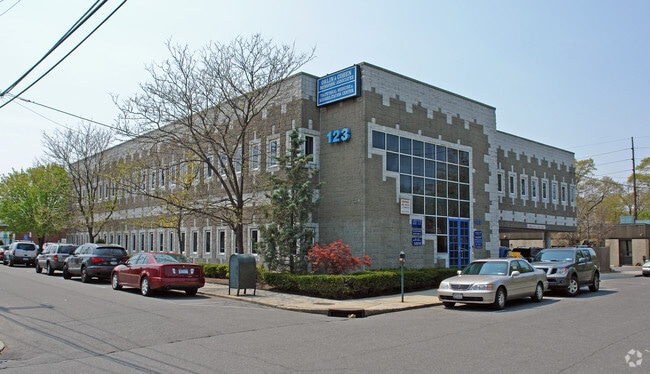
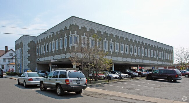
Property Detail
123 Maple Ave
Nassau County-Suffolk County, NY
101-102
2003-39-261-00-0101-0
Nassau
Officebuilding
New York
B and X Area of moderate flood hazard, usually the area between the limits of the 100-year and 500-year floods.
101-1
2025
0.28 AC
2026
Southern Nassau
411200
Long Island (New York)
28,983 SF
NEARBY LISTINGS FOR SALE OR LEASE
DEMOGRAPHICS near 123 Maple Ave
1 mile
3 mile
5 mile
2025 Total Population
24,084
173,479
464,462
2030 Population
24,184
172,438
459,112
Pop Growth 2025-2030
+ 0.42%
(0.60%)
(1.15%)
Average Age
38
40
41
2025 Total Households
7,230
54,638
153,437
HH Growth 2025-2030
+ 0.44%
(0.85%)
(1.35%)
Median Household Inc
$134,573
$102,242
$107,261
Avg Household Size
3.20
3.00
2.80
2025 Avg HH Vehicles
2.00
1.00
2.00
Median Home Value
$944,013
$773,176
$716,704
Median Year Built
1954
1957
1956
Nearby Places
Map Layers
Map Styles
 Street
 Aerial
Layers
 Traffic
 Biking
Places
Listings with unknown addresses are not visible on the map
- Restaurants
- Banks
- Shops
- Fitness
- Groceries
PUBLIC TRANSPORTATION
TRANSIT/SUBWAY
Cedarhurst Station (Far Rockaway Branch - Long Island Rail Road)
Drive
Walk
Distance
Cedarhurst Station (Far Rockaway Branch - Long Island Rail Road)
1 min
5 min
0.3 mi
Woodmere Station (Far Rockaway Branch - Long Island Rail Road)
Drive
Walk
Distance
Woodmere Station (Far Rockaway Branch - Long Island Rail Road)
3 min
17 min
0.9 mi
COMMUTER RAIL
Cedarhurst Station (Far Rockaway Branch - Long Island Rail Road)
Drive
Walk
Distance
Cedarhurst Station (Far Rockaway Branch - Long Island Rail Road)
1 min
5 min
0.3 mi
Woodmere Station (Far Rockaway Branch - Long Island Rail Road)
Drive
Walk
Distance
Woodmere Station (Far Rockaway Branch - Long Island Rail Road)
2 min
13 min
0.7 mi
AIRPORT
John F Kennedy International
Drive
Walk
Distance
John F Kennedy International
18 min
7.7 mi
LaGuardia
Drive
Walk
Distance
LaGuardia
28 min
14.8 mi
Newark Liberty International
Drive
Walk
Distance
Newark Liberty International
56 min
34.5 mi
Freight Ports
NY - Red Hook Container Terminal
Drive
Walk
Distance
NY - Red Hook Container Terminal
38 min
18.9 mi
The World's #1 Commercial Real Estate Marketplace
Connect with us
© 2026 CoStar Group
The information above has been obtained from sources believed reliable. While we do not doubt its accuracy we have not verified it and make no guarantee, warranty or representation about it. It is your responsibility to independently confirm its accuracy and completeness. Any projections, opinions, assumptions, or estimates used are for example only and do not represent the current or future performance of the property. The value of this transaction to you depends on tax and other factors which should be evaluated by your tax, financial, and legal advisors. You and your advisors should conduct a careful, independent investigation of the property to determine to your satisfaction the suitability of the property for your needs.