Property Record
123 Sharon Rd, Robbinsville, NJ 08691

Save to a Folder
{{folder.Name}}
{{folder.ListingIds.length}} Properties
{{folder.ListingIds.length}} Property
Create a New Folder
Property Detail
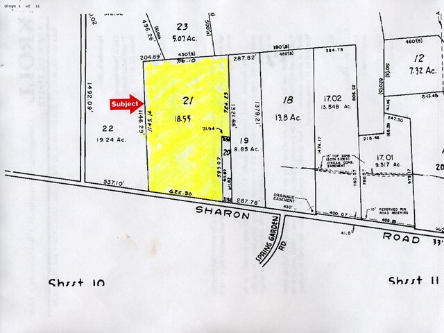
123 Sharon Rd
12-00026-0000-00021
MERCER
Farms
New Jersey
RR
21
B and X Area of moderate flood hazard, usually the area between the limits of the 100-year and 500-year floods.
18.55 AC
2025
Trenton
2026
Northern New Jersey
004309
Trenton-Princeton, NJ
1,400 SF
NEARBY LISTINGS FOR SALE OR LEASE
DEMOGRAPHICS near 123 Sharon Rd
1 mile
3 mile
5 mile
2025 Total Population
2,686
23,873
84,608
2030 Population
2,760
24,603
86,747
Pop Growth 2025-2030
+ 2.76%
+ 3.06%
+ 2.53%
Average Age
39
41
44
2025 Total Households
933
8,613
31,949
HH Growth 2025-2030
+ 2.89%
+ 3.13%
+ 2.61%
Median Household Inc
$184,712
$147,432
$123,913
Avg Household Size
2.90
2.70
2.60
2025 Avg HH Vehicles
2.00
2.00
2.00
Median Home Value
$669,741
$508,988
$449,831
Median Year Built
1984
1988
1979
Nearby Places
Map Layers
Map Styles
 Street
 Aerial
Layers
 Traffic
 Biking
Places
Listings with unknown addresses are not visible on the map
- Restaurants
- Banks
- Shops
- Fitness
- Groceries
PUBLIC TRANSPORTATION
COMMUTER RAIL
Hamilton (Northeast Corridor - NJ TRANSIT RAIL)
Drive
Walk
Distance
Hamilton (Northeast Corridor - NJ TRANSIT RAIL)
15 min
7.4 mi
Princeton Jct. (Keystone Service - NJ TRANSIT RAIL, Northeast Corridor - NJ TRANSIT RAIL, Northeast Regional - NJ TRANSIT RAIL, Princeton Shuttle - NJ TRANSIT RAIL)
Drive
Walk
Distance
Princeton Jct. (Keystone Service - NJ TRANSIT RAIL, Northeast Corridor - NJ TRANSIT RAIL, Northeast Regional - NJ TRANSIT RAIL, Princeton Shuttle - NJ TRANSIT RAIL)
18 min
9.8 mi
AIRPORT
Trenton Mercer
Drive
Walk
Distance
Trenton Mercer
28 min
16.9 mi
Freight Ports
Port of Philadelphia
Drive
Walk
Distance
Port of Philadelphia
52 min
38.3 mi
Nearby Properties
Address
Land Use
TOTAL SIZE
Lot Size
Zoning
Address
Land Use
TOTAL SIZE
Lot Size
Zoning
110.44 AC
OW
Address
Land Use
TOTAL SIZE
Lot Size
Zoning
31.05 AC
Address
Land Use
TOTAL SIZE
Lot Size
Zoning
55.71 AC
PCD
Address
Land Use
TOTAL SIZE
Lot Size
Zoning
64.43 AC
PCD
Address
Land Use
TOTAL SIZE
Lot Size
Zoning
65.18 AC
PCD
Address
Land Use
TOTAL SIZE
Lot Size
Zoning
47.91 AC
PCD
Address
Land Use
TOTAL SIZE
Lot Size
Zoning
79.71 AC
PCD
Address
Land Use
TOTAL SIZE
Lot Size
Zoning
23.13 AC
RR
Address
Land Use
TOTAL SIZE
Lot Size
Zoning
60.18 AC
PCD
Address
Land Use
TOTAL SIZE
Lot Size
Zoning
266,000 SF
56.90 AC
RD
Address
Land Use
TOTAL SIZE
Lot Size
Zoning
37.90 AC
PCD
Address
Land Use
TOTAL SIZE
Lot Size
Zoning
134,000 SF
117.90 AC
AR
Address
Land Use
TOTAL SIZE
Lot Size
Zoning
50.05 AC
RR
Address
Land Use
TOTAL SIZE
Lot Size
Zoning
104.44 AC
PCD
Address
Land Use
TOTAL SIZE
Lot Size
Zoning
22.91 AC
PCD
Address
Land Use
TOTAL SIZE
Lot Size
Zoning
30.70 AC
PCD
Address
Land Use
TOTAL SIZE
Lot Size
Zoning
21.62 AC
RD
Address
Land Use
TOTAL SIZE
Lot Size
Zoning
38.78 AC
PCD
Address
Land Use
TOTAL SIZE
Lot Size
Zoning
46.35 AC
PCD
Address
Land Use
TOTAL SIZE
Lot Size
Zoning
77,722 SF
39.13 AC
Address
Land Use
TOTAL SIZE
Lot Size
Zoning
38.54 AC
OW
Address
Land Use
TOTAL SIZE
Lot Size
Zoning
141,175 SF
17.06 AC
RD
Address
Land Use
TOTAL SIZE
Lot Size
Zoning
11.16 AC
PCD
Address
Land Use
TOTAL SIZE
Lot Size
Zoning
22.73 AC
PCD
Address
Land Use
TOTAL SIZE
Lot Size
Zoning
40.24 AC
RD
Address
Land Use
TOTAL SIZE
Lot Size
Zoning
15.51 AC
R7
Address
Land Use
TOTAL SIZE
Lot Size
Zoning
25.32 AC
RD
Address
Land Use
TOTAL SIZE
Lot Size
Zoning
10 AC
PCD
Address
Land Use
TOTAL SIZE
Lot Size
Zoning
79.71 AC
PCD
Address
Land Use
TOTAL SIZE
Lot Size
Zoning
136,664 SF
14.16 AC
RD
The World's #1 Commercial Real Estate Marketplace
Connect with us
© 2026 CoStar Group
The information above has been obtained from sources believed reliable. While we do not doubt its accuracy we have not verified it and make no guarantee, warranty or representation about it. It is your responsibility to independently confirm its accuracy and completeness. Any projections, opinions, assumptions, or estimates used are for example only and do not represent the current or future performance of the property. The value of this transaction to you depends on tax and other factors which should be evaluated by your tax, financial, and legal advisors. You and your advisors should conduct a careful, independent investigation of the property to determine to your satisfaction the suitability of the property for your needs.