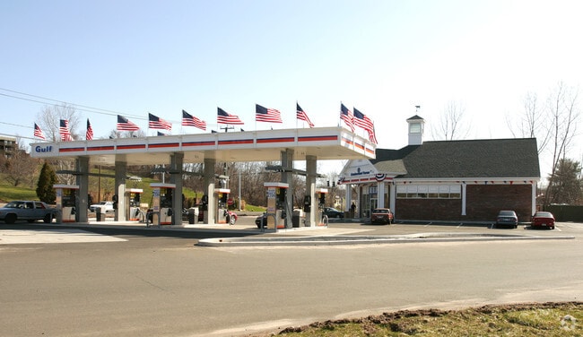
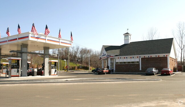
Property Record
123 West St, Cromwell, CT 06416

Property Detail
123 West St
CROM-000031-000031-000009A
MIDDLESEX
Commercialnec
Connecticut
R-15
9a
B and X Area of moderate flood hazard, usually the area between the limits of the 100-year and 500-year floods.
14.17 AC
2025
NW Middlesex/Middletown
2025
Hartford
570300
Hartford-West Hartford-East Hartford, CT
NEARBY LISTINGS FOR SALE OR LEASE
DEMOGRAPHICS near 123 West St
1 mile
3 mile
5 mile
2025 Total Population
5,482
42,342
95,731
2030 Population
5,495
42,791
96,970
Pop Growth 2025-2030
+ 0.24%
+ 1.06%
+ 1.29%
Average Age
45
41
42
2025 Total Households
2,327
18,646
39,954
HH Growth 2025-2030
+ 0.21%
+ 1.05%
+ 1.30%
Median Household Inc
$107,101
$83,790
$88,630
Avg Household Size
2.20
2.20
2.20
2025 Avg HH Vehicles
2.00
2.00
2.00
Median Home Value
$337,163
$314,567
$338,330
Median Year Built
1975
1975
1974
Nearby Places
Map Layers
Map Styles
 Street
 Aerial
Layers
 Traffic
 Biking
Places
Listings with unknown addresses are not visible on the map
- Restaurants
- Banks
- Shops
- Fitness
- Groceries
PUBLIC TRANSPORTATION
COMMUTER RAIL
Berlin (Hartford Line - CONN DOT)
Drive
Walk
Distance
Berlin (Hartford Line - CONN DOT)
11 min
6.8 mi
Berlin Amtrak (Amtrak Hartford Line - Amtrak, Northeast Regional - Amtrak, Valley Flyer - Amtrak)
Drive
Walk
Distance
Berlin Amtrak (Amtrak Hartford Line - Amtrak, Northeast Regional - Amtrak, Valley Flyer - Amtrak)
11 min
6.8 mi
AIRPORT
Bradley International
Drive
Walk
Distance
Bradley International
48 min
30.0 mi
Tweed/New Haven
Drive
Walk
Distance
Tweed/New Haven
46 min
31.5 mi
Freight Ports
Port of New Haven
Drive
Walk
Distance
Port of New Haven
41 min
29.2 mi
Nearby Properties
Address
Land Use
TOTAL SIZE
Lot Size
Zoning
Address
Land Use
TOTAL SIZE
Lot Size
Zoning
24.70 AC
R-20
Address
Land Use
TOTAL SIZE
Lot Size
Zoning
117,178 SF
13.02 AC
R-20
Address
Land Use
TOTAL SIZE
Lot Size
Zoning
33,524 SF
37.71 AC
ID
Address
Land Use
TOTAL SIZE
Lot Size
Zoning
43.15 AC
R-20
Address
Land Use
TOTAL SIZE
Lot Size
Zoning
17.38 AC
PRD
Address
Land Use
TOTAL SIZE
Lot Size
Zoning
29.45 AC
R-15
Address
Land Use
TOTAL SIZE
Lot Size
Zoning
248,626 SF
92.26 AC
BP-2
Address
Land Use
TOTAL SIZE
Lot Size
Zoning
403,000 SF
33.55 AC
IND
Address
Land Use
TOTAL SIZE
Lot Size
Zoning
27.21 AC
M
Address
Land Use
TOTAL SIZE
Lot Size
Zoning
23.08 AC
BP-2
Address
Land Use
TOTAL SIZE
Lot Size
Zoning
Address
Land Use
TOTAL SIZE
Lot Size
Zoning
15.10 AC
PRD
Address
Land Use
TOTAL SIZE
Lot Size
Zoning
19.49 AC
PRD
Address
Land Use
TOTAL SIZE
Lot Size
Zoning
11.81 AC
PRD
Address
Land Use
TOTAL SIZE
Lot Size
Zoning
310,582 SF
32.72 AC
OP
Address
Land Use
TOTAL SIZE
Lot Size
Zoning
27,152 SF
8.75 AC
R-25
Address
Land Use
TOTAL SIZE
Lot Size
Zoning
10.10 AC
IND
Address
Land Use
TOTAL SIZE
Lot Size
Zoning
9.81 AC
OP
Address
Land Use
TOTAL SIZE
Lot Size
Zoning
24.45 AC
HB
Address
Land Use
TOTAL SIZE
Lot Size
Zoning
129,626 SF
22.36 AC
IT
Address
Land Use
TOTAL SIZE
Lot Size
Zoning
13.28 AC
PRD
Address
Land Use
TOTAL SIZE
Lot Size
Zoning
83,241 SF
52.65 AC
R-15
Address
Land Use
TOTAL SIZE
Lot Size
Zoning
49,724 SF
9.02 AC
OP
Address
Land Use
TOTAL SIZE
Lot Size
Zoning
15.50 AC
PRD
Address
Land Use
TOTAL SIZE
Lot Size
Zoning
161,959 SF
45.61 AC
R-25
Address
Land Use
TOTAL SIZE
Lot Size
Zoning
15,395 SF
158.10 AC
R-25
Address
Land Use
TOTAL SIZE
Lot Size
Zoning
88,369 SF
26 AC
R-15
Address
Land Use
TOTAL SIZE
Lot Size
Zoning
80,627 SF
10.54 AC
HB
Address
Land Use
TOTAL SIZE
Lot Size
Zoning
146.96 AC
IND
Address
Land Use
TOTAL SIZE
Lot Size
Zoning
105,456 SF
11.91 AC
OP
The World's #1 Commercial Real Estate Marketplace
Connect with us
© 2026 CoStar Group
The information above has been obtained from sources believed reliable. While we do not doubt its accuracy we have not verified it and make no guarantee, warranty or representation about it. It is your responsibility to independently confirm its accuracy and completeness. Any projections, opinions, assumptions, or estimates used are for example only and do not represent the current or future performance of the property. The value of this transaction to you depends on tax and other factors which should be evaluated by your tax, financial, and legal advisors. You and your advisors should conduct a careful, independent investigation of the property to determine to your satisfaction the suitability of the property for your needs.